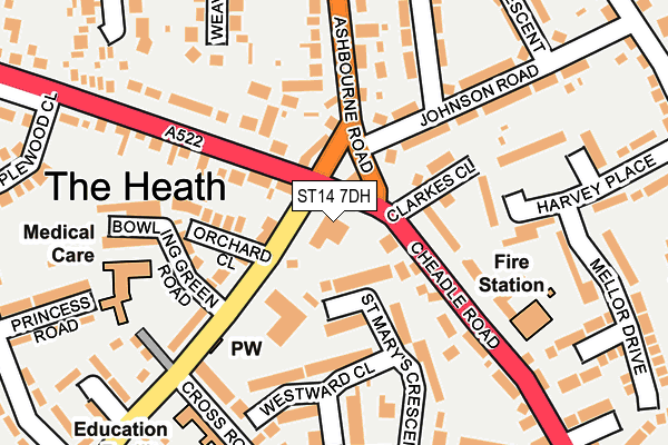
ST14 7DH is located in the Heath electoral ward, within the local authority district of East Staffordshire and the English Parliamentary constituency of Burton. The Sub Integrated Care Board (ICB) Location is NHS Staffordshire and Stoke-on-Trent ICB - 05D and the police force is Staffordshire. This postcode has been in use since December 1995.


GetTheData
Source: OS OpenMap – Local (Ordnance Survey)
Source: OS VectorMap District (Ordnance Survey)
Licence: Open Government Licence (requires attribution)
| Easting | 408678 |
| Northing | 334303 |
| Latitude | 52.906092 |
| Longitude | -1.872419 |
GetTheData
Source: Open Postcode Geo
Licence: Open Government Licence
| Country | England |
| Postcode District | ST14 |
➜ See where ST14 is on a map ➜ Where is Uttoxeter? | |
GetTheData
Source: Land Registry Price Paid Data
Licence: Open Government Licence
Elevation or altitude of ST14 7DH as distance above sea level:
| Metres | Feet | |
|---|---|---|
| Elevation | 100m | 328ft |
Elevation is measured from the approximate centre of the postcode, to the nearest point on an OS contour line from OS Terrain 50, which has contour spacing of ten vertical metres.
➜ How high above sea level am I? Find the elevation of your current position using your device's GPS.
GetTheData
Source: Open Postcode Elevation
Licence: Open Government Licence
| Ward | Heath |
| Constituency | Burton |
GetTheData
Source: ONS Postcode Database
Licence: Open Government Licence
| Orchard Close (Holly Road) | The Heath | 39m |
| Orchard Close (Holly Road) | The Heath | 42m |
| Holly Road (New Road) | Uttoxeter | 88m |
| The Fire Station (Cheadle Road) | The Wharf | 109m |
| House No. 1 (Ashbourne Road) | Uttoxeter | 115m |
| Uttoxeter Station | 1.5km |
GetTheData
Source: NaPTAN
Licence: Open Government Licence
GetTheData
Source: ONS Postcode Database
Licence: Open Government Licence


➜ Get more ratings from the Food Standards Agency
GetTheData
Source: Food Standards Agency
Licence: FSA terms & conditions
| Last Collection | |||
|---|---|---|---|
| Location | Mon-Fri | Sat | Distance |
| Copes Way | 17:00 | 07:30 | 698m |
| Uttoxeter Post Office | 18:15 | 12:15 | 985m |
| Park Crescent | 16:00 | 08:00 | 2,924m |
GetTheData
Source: Dracos
Licence: Creative Commons Attribution-ShareAlike
The below table lists the International Territorial Level (ITL) codes (formerly Nomenclature of Territorial Units for Statistics (NUTS) codes) and Local Administrative Units (LAU) codes for ST14 7DH:
| ITL 1 Code | Name |
|---|---|
| TLG | West Midlands (England) |
| ITL 2 Code | Name |
| TLG2 | Shropshire and Staffordshire |
| ITL 3 Code | Name |
| TLG24 | Staffordshire CC |
| LAU 1 Code | Name |
| E07000193 | East Staffordshire |
GetTheData
Source: ONS Postcode Directory
Licence: Open Government Licence
The below table lists the Census Output Area (OA), Lower Layer Super Output Area (LSOA), and Middle Layer Super Output Area (MSOA) for ST14 7DH:
| Code | Name | |
|---|---|---|
| OA | E00150110 | |
| LSOA | E01029461 | East Staffordshire 003C |
| MSOA | E02006133 | East Staffordshire 003 |
GetTheData
Source: ONS Postcode Directory
Licence: Open Government Licence
| ST14 7DX | Holly Road | 91m |
| ST14 7BH | St Marys Crescent | 103m |
| ST14 7BY | Cheadle Road | 106m |
| ST14 7BZ | Clarkes Close | 110m |
| ST14 7DZ | Orchard Close | 114m |
| ST14 7BJ | Westward Close | 134m |
| ST14 7DY | Holly Road | 148m |
| ST14 7HW | Bowling Green Road | 161m |
| ST14 7BX | Cheadle Road | 165m |
| ST14 7AS | Johnson Road | 174m |
GetTheData
Source: Open Postcode Geo; Land Registry Price Paid Data
Licence: Open Government Licence