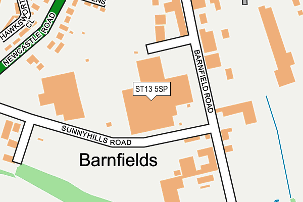
ST13 5SP is located in the Leek South electoral ward, within the local authority district of Staffordshire Moorlands and the English Parliamentary constituency of Staffordshire Moorlands. The Sub Integrated Care Board (ICB) Location is NHS Staffordshire and Stoke-on-Trent ICB - 05G and the police force is Staffordshire. This postcode has been in use since March 1988.


GetTheData
Source: OS OpenMap – Local (Ordnance Survey)
Source: OS VectorMap District (Ordnance Survey)
Licence: Open Government Licence (requires attribution)
| Easting | 397876 |
| Northing | 355399 |
| Latitude | 53.095791 |
| Longitude | -2.033171 |
GetTheData
Source: Open Postcode Geo
Licence: Open Government Licence
| Country | England |
| Postcode District | ST13 |
➜ See where ST13 is on a map ➜ Where is Leek? | |
GetTheData
Source: Land Registry Price Paid Data
Licence: Open Government Licence
Elevation or altitude of ST13 5SP as distance above sea level:
| Metres | Feet | |
|---|---|---|
| Elevation | 150m | 492ft |
Elevation is measured from the approximate centre of the postcode, to the nearest point on an OS contour line from OS Terrain 50, which has contour spacing of ten vertical metres.
➜ How high above sea level am I? Find the elevation of your current position using your device's GPS.
GetTheData
Source: Open Postcode Elevation
Licence: Open Government Licence
| Ward | Leek South |
| Constituency | Staffordshire Moorlands |
GetTheData
Source: ONS Postcode Database
Licence: Open Government Licence
| Wallbridge Drive (Newcastle Rd) | Barnfields | 278m |
| Campbell Avenue (Newcastle Rd) | Barnfields | 304m |
| Campbell Avenue (Newcastle Rd) | Barnfields | 338m |
| Wallbridge Drive (Newcastle Road) | Barnfields | 365m |
| Sandon Street (Junction Rd) | Barnfields | 445m |
GetTheData
Source: NaPTAN
Licence: Open Government Licence
GetTheData
Source: ONS Postcode Database
Licence: Open Government Licence


➜ Get more ratings from the Food Standards Agency
GetTheData
Source: Food Standards Agency
Licence: FSA terms & conditions
| Last Collection | |||
|---|---|---|---|
| Location | Mon-Fri | Sat | Distance |
| Campbell Avenue | 17:00 | 11:15 | 375m |
| Wallbridge | 17:00 | 11:30 | 607m |
| Burton Street | 17:00 | 11:00 | 613m |
GetTheData
Source: Dracos
Licence: Creative Commons Attribution-ShareAlike
The below table lists the International Territorial Level (ITL) codes (formerly Nomenclature of Territorial Units for Statistics (NUTS) codes) and Local Administrative Units (LAU) codes for ST13 5SP:
| ITL 1 Code | Name |
|---|---|
| TLG | West Midlands (England) |
| ITL 2 Code | Name |
| TLG2 | Shropshire and Staffordshire |
| ITL 3 Code | Name |
| TLG24 | Staffordshire CC |
| LAU 1 Code | Name |
| E07000198 | Staffordshire Moorlands |
GetTheData
Source: ONS Postcode Directory
Licence: Open Government Licence
The below table lists the Census Output Area (OA), Lower Layer Super Output Area (LSOA), and Middle Layer Super Output Area (MSOA) for ST13 5SP:
| Code | Name | |
|---|---|---|
| OA | E00151922 | |
| LSOA | E01029813 | Staffordshire Moorlands 006D |
| MSOA | E02006209 | Staffordshire Moorlands 006 |
GetTheData
Source: ONS Postcode Directory
Licence: Open Government Licence
| ST13 5SR | Grange Gardens | 217m |
| ST13 5QG | Barnfield Road Industrial Estate | 232m |
| ST13 5RT | Newcastle Road | 248m |
| ST13 5RX | Newcastle Road | 299m |
| ST13 8HH | Hawksworth Close | 319m |
| ST13 5RU | Newcastle Road | 322m |
| ST13 5QP | Junction Road | 364m |
| ST13 5RS | Hawksworth Avenue | 384m |
| ST13 8HL | Wallbridge Drive | 389m |
| ST13 5QR | Sandon Street | 397m |
GetTheData
Source: Open Postcode Geo; Land Registry Price Paid Data
Licence: Open Government Licence