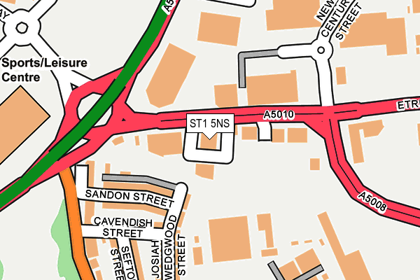
ST1 5NS lies on Etruria Road in Stoke-on-trent. ST1 5NS is located in the Etruria & Hanley electoral ward, within the unitary authority of Stoke-on-Trent and the English Parliamentary constituency of Stoke-on-Trent Central. The Sub Integrated Care Board (ICB) Location is NHS Staffordshire and Stoke-on-Trent ICB - 05W and the police force is Staffordshire. This postcode has been in use since January 1980.


GetTheData
Source: OS OpenMap – Local (Ordnance Survey)
Source: OS VectorMap District (Ordnance Survey)
Licence: Open Government Licence (requires attribution)
| Easting | 387462 |
| Northing | 347526 |
| Latitude | 53.024893 |
| Longitude | -2.188378 |
GetTheData
Source: Open Postcode Geo
Licence: Open Government Licence
| Street | Etruria Road |
| Town/City | Stoke-on-trent |
| Country | England |
| Postcode District | ST1 |
➜ See where ST1 is on a map ➜ Where is Stoke-on-Trent? | |
GetTheData
Source: Land Registry Price Paid Data
Licence: Open Government Licence
Elevation or altitude of ST1 5NS as distance above sea level:
| Metres | Feet | |
|---|---|---|
| Elevation | 130m | 427ft |
Elevation is measured from the approximate centre of the postcode, to the nearest point on an OS contour line from OS Terrain 50, which has contour spacing of ten vertical metres.
➜ How high above sea level am I? Find the elevation of your current position using your device's GPS.
GetTheData
Source: Open Postcode Elevation
Licence: Open Government Licence
| Ward | Etruria & Hanley |
| Constituency | Stoke-on-trent Central |
GetTheData
Source: ONS Postcode Database
Licence: Open Government Licence
203 - 205, ETRURIA ROAD, STOKE-ON-TRENT, ST1 5NS 2000 14 APR £39,000 |
GetTheData
Source: HM Land Registry Price Paid Data
Licence: Contains HM Land Registry data © Crown copyright and database right 2025. This data is licensed under the Open Government Licence v3.0.
| The Plough (Etruria Road) | Hanley | 30m |
| Octagon Centre (Etruria Road) | Hanley | 90m |
| Etruria Park (Etruria Vale Road) | Etruria | 280m |
| Etruria Park (Etruria Vale Road) | Etruria | 301m |
| Mount Pleasant (Clough Street) | Hanley | 304m |
| Stoke-on-Trent Station | 1.9km |
| Longport Station | 2.7km |
| Longton Station | 5.2km |
GetTheData
Source: NaPTAN
Licence: Open Government Licence
GetTheData
Source: ONS Postcode Database
Licence: Open Government Licence


➜ Get more ratings from the Food Standards Agency
GetTheData
Source: Food Standards Agency
Licence: FSA terms & conditions
| Last Collection | |||
|---|---|---|---|
| Location | Mon-Fri | Sat | Distance |
| Etruria Park | 17:15 | 11:00 | 252m |
| Etruria Vale Road | 17:30 | 11:00 | 559m |
| Belmont Road | 17:15 | 11:00 | 565m |
GetTheData
Source: Dracos
Licence: Creative Commons Attribution-ShareAlike
The below table lists the International Territorial Level (ITL) codes (formerly Nomenclature of Territorial Units for Statistics (NUTS) codes) and Local Administrative Units (LAU) codes for ST1 5NS:
| ITL 1 Code | Name |
|---|---|
| TLG | West Midlands (England) |
| ITL 2 Code | Name |
| TLG2 | Shropshire and Staffordshire |
| ITL 3 Code | Name |
| TLG23 | Stoke-on-Trent |
| LAU 1 Code | Name |
| E06000021 | Stoke-on-Trent |
GetTheData
Source: ONS Postcode Directory
Licence: Open Government Licence
The below table lists the Census Output Area (OA), Lower Layer Super Output Area (LSOA), and Middle Layer Super Output Area (MSOA) for ST1 5NS:
| Code | Name | |
|---|---|---|
| OA | E00072124 | |
| LSOA | E01014285 | Stoke-on-Trent 015B |
| MSOA | E02002965 | Stoke-on-Trent 015 |
GetTheData
Source: ONS Postcode Directory
Licence: Open Government Licence
| ST1 4BE | Railway View | 171m |
| ST1 4BJ | Sandon Street | 177m |
| ST1 4DG | Josiah Wedgwood Street | 190m |
| ST1 4BH | Cavendish Street | 198m |
| ST1 4BQ | Sefton Street | 253m |
| ST1 4BL | Etruria Vale Road | 257m |
| ST1 4BG | Garnet Street | 280m |
| ST1 5NH | Etruria Road | 283m |
| ST1 4BA | Clough Street | 336m |
| ST1 4BB | Broomfield Place South | 377m |
GetTheData
Source: Open Postcode Geo; Land Registry Price Paid Data
Licence: Open Government Licence