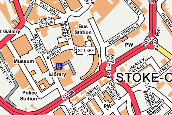
ST1 3BF is located in the Etruria & Hanley electoral ward, within the unitary authority of Stoke-on-Trent and the English Parliamentary constituency of Stoke-on-Trent Central. The Sub Integrated Care Board (ICB) Location is NHS Staffordshire and Stoke-on-Trent ICB - 05W and the police force is Staffordshire. This postcode has been in use since July 2013.


GetTheData
Source: OS OpenMap – Local (Ordnance Survey)
Source: OS VectorMap District (Ordnance Survey)
Licence: Open Government Licence (requires attribution)
| Easting | 388373 |
| Northing | 347265 |
| Latitude | 53.022568 |
| Longitude | -2.174786 |
GetTheData
Source: Open Postcode Geo
Licence: Open Government Licence
| Country | England |
| Postcode District | ST1 |
➜ See where ST1 is on a map ➜ Where is Stoke-on-Trent? | |
GetTheData
Source: Land Registry Price Paid Data
Licence: Open Government Licence
Elevation or altitude of ST1 3BF as distance above sea level:
| Metres | Feet | |
|---|---|---|
| Elevation | 160m | 525ft |
Elevation is measured from the approximate centre of the postcode, to the nearest point on an OS contour line from OS Terrain 50, which has contour spacing of ten vertical metres.
➜ How high above sea level am I? Find the elevation of your current position using your device's GPS.
GetTheData
Source: Open Postcode Elevation
Licence: Open Government Licence
| Ward | Etruria & Hanley |
| Constituency | Stoke-on-trent Central |
GetTheData
Source: ONS Postcode Database
Licence: Open Government Licence
| Bus Station | Hanley | 61m |
| Stop J1 (John Street) | Hanley | 91m |
| Jasper Street (Lichfield Street) | Hanley | 127m |
| Stop P1 (Pall Mall) | Hanley | 180m |
| Stop B 1 (Bethesda Street) | Hanley | 190m |
| Stoke-on-Trent Station | 1.7km |
| Longport Station | 3.5km |
| Longton Station | 4.4km |
GetTheData
Source: NaPTAN
Licence: Open Government Licence
GetTheData
Source: ONS Postcode Database
Licence: Open Government Licence


➜ Get more ratings from the Food Standards Agency
GetTheData
Source: Food Standards Agency
Licence: FSA terms & conditions
| Last Collection | |||
|---|---|---|---|
| Location | Mon-Fri | Sat | Distance |
| Victoria Hall | 17:30 | 11:45 | 144m |
| East Precinct | 18:00 | 12:00 | 269m |
| Market Square | 18:15 | 12:30 | 442m |
GetTheData
Source: Dracos
Licence: Creative Commons Attribution-ShareAlike
The below table lists the International Territorial Level (ITL) codes (formerly Nomenclature of Territorial Units for Statistics (NUTS) codes) and Local Administrative Units (LAU) codes for ST1 3BF:
| ITL 1 Code | Name |
|---|---|
| TLG | West Midlands (England) |
| ITL 2 Code | Name |
| TLG2 | Shropshire and Staffordshire |
| ITL 3 Code | Name |
| TLG23 | Stoke-on-Trent |
| LAU 1 Code | Name |
| E06000021 | Stoke-on-Trent |
GetTheData
Source: ONS Postcode Directory
Licence: Open Government Licence
The below table lists the Census Output Area (OA), Lower Layer Super Output Area (LSOA), and Middle Layer Super Output Area (MSOA) for ST1 3BF:
| Code | Name | |
|---|---|---|
| OA | E00072125 | |
| LSOA | E01014287 | Stoke-on-Trent 015D |
| MSOA | E02002965 | Stoke-on-Trent 015 |
GetTheData
Source: ONS Postcode Directory
Licence: Open Government Licence
| ST1 3AD | Bagnall Street | 121m |
| ST1 3DA | Jasper Street | 121m |
| ST1 3EA | Lichfield Street | 129m |
| ST1 3BY | Downey Street | 162m |
| ST1 3JN | Birch Terrace | 164m |
| ST1 3DE | Lower Bethesda Street | 165m |
| ST1 3DB | Eastwood Place | 182m |
| ST1 3DD | Brunswick Place | 185m |
| ST1 3LA | Harley Street | 186m |
| ST1 1QH | Albion Street | 187m |
GetTheData
Source: Open Postcode Geo; Land Registry Price Paid Data
Licence: Open Government Licence