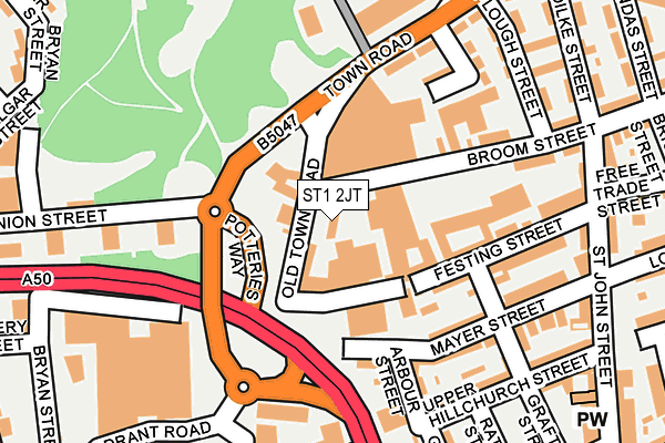
ST1 2JT is located in the Birches Head & Northwood electoral ward, within the unitary authority of Stoke-on-Trent and the English Parliamentary constituency of Stoke-on-Trent Central. The Sub Integrated Care Board (ICB) Location is NHS Staffordshire and Stoke-on-Trent ICB - 05W and the police force is Staffordshire. This postcode has been in use since January 1980.


GetTheData
Source: OS OpenMap – Local (Ordnance Survey)
Source: OS VectorMap District (Ordnance Survey)
Licence: Open Government Licence (requires attribution)
| Easting | 388467 |
| Northing | 348096 |
| Latitude | 53.030039 |
| Longitude | -2.173415 |
GetTheData
Source: Open Postcode Geo
Licence: Open Government Licence
| Country | England |
| Postcode District | ST1 |
➜ See where ST1 is on a map ➜ Where is Stoke-on-Trent? | |
GetTheData
Source: Land Registry Price Paid Data
Licence: Open Government Licence
Elevation or altitude of ST1 2JT as distance above sea level:
| Metres | Feet | |
|---|---|---|
| Elevation | 180m | 591ft |
Elevation is measured from the approximate centre of the postcode, to the nearest point on an OS contour line from OS Terrain 50, which has contour spacing of ten vertical metres.
➜ How high above sea level am I? Find the elevation of your current position using your device's GPS.
GetTheData
Source: Open Postcode Elevation
Licence: Open Government Licence
| Ward | Birches Head & Northwood |
| Constituency | Stoke-on-trent Central |
GetTheData
Source: ONS Postcode Database
Licence: Open Government Licence
| Old Town Road (Town Road) | Hanley | 91m |
| Old Town Road (Town Road) | Hanley | 108m |
| Stop Q2 (Quadrant Road) | Hanley | 246m |
| Union Street | Hanley | 253m |
| Union Street | Hanley | 253m |
| Stoke-on-Trent Station | 2.5km |
| Longport Station | 3.2km |
| Longton Station | 5.1km |
GetTheData
Source: NaPTAN
Licence: Open Government Licence
| Percentage of properties with Next Generation Access | 100.0% |
| Percentage of properties with Superfast Broadband | 100.0% |
| Percentage of properties with Ultrafast Broadband | 0.0% |
| Percentage of properties with Full Fibre Broadband | 0.0% |
Superfast Broadband is between 30Mbps and 300Mbps
Ultrafast Broadband is > 300Mbps
| Percentage of properties unable to receive 2Mbps | 0.0% |
| Percentage of properties unable to receive 5Mbps | 0.0% |
| Percentage of properties unable to receive 10Mbps | 0.0% |
| Percentage of properties unable to receive 30Mbps | 0.0% |
GetTheData
Source: Ofcom
Licence: Ofcom Terms of Use (requires attribution)
GetTheData
Source: ONS Postcode Database
Licence: Open Government Licence


➜ Get more ratings from the Food Standards Agency
GetTheData
Source: Food Standards Agency
Licence: FSA terms & conditions
| Last Collection | |||
|---|---|---|---|
| Location | Mon-Fri | Sat | Distance |
| St John Street | 17:30 | 10:15 | 253m |
| Garth Street | 17:30 | 10:30 | 320m |
| Union Street | 18:00 | 10:30 | 354m |
GetTheData
Source: Dracos
Licence: Creative Commons Attribution-ShareAlike
The below table lists the International Territorial Level (ITL) codes (formerly Nomenclature of Territorial Units for Statistics (NUTS) codes) and Local Administrative Units (LAU) codes for ST1 2JT:
| ITL 1 Code | Name |
|---|---|
| TLG | West Midlands (England) |
| ITL 2 Code | Name |
| TLG2 | Shropshire and Staffordshire |
| ITL 3 Code | Name |
| TLG23 | Stoke-on-Trent |
| LAU 1 Code | Name |
| E06000021 | Stoke-on-Trent |
GetTheData
Source: ONS Postcode Directory
Licence: Open Government Licence
The below table lists the Census Output Area (OA), Lower Layer Super Output Area (LSOA), and Middle Layer Super Output Area (MSOA) for ST1 2JT:
| Code | Name | |
|---|---|---|
| OA | E00072322 | |
| LSOA | E01014330 | Stoke-on-Trent 013E |
| MSOA | E02002963 | Stoke-on-Trent 013 |
GetTheData
Source: ONS Postcode Directory
Licence: Open Government Licence
| ST1 2JS | Old Town Road | 38m |
| ST1 5AD | Union Street | 152m |
| ST1 2JB | Mayer Street | 154m |
| ST1 2JA | Festing Street | 157m |
| ST1 2HF | Arbour Street | 161m |
| ST1 2LF | Southampton Street | 161m |
| ST1 2HN | Grafton Street | 161m |
| ST1 2JD | Mayer Street | 164m |
| ST1 2EW | Broom Street | 165m |
| ST1 2HY | Festing Street | 176m |
GetTheData
Source: Open Postcode Geo; Land Registry Price Paid Data
Licence: Open Government Licence