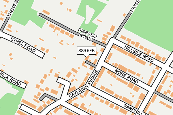
SS9 5FB lies on Howards Way in Eastwood, Leigh-on-sea. SS9 5FB is located in the Lodge electoral ward, within the local authority district of Rochford and the English Parliamentary constituency of Rayleigh and Wickford. The Sub Integrated Care Board (ICB) Location is NHS Mid and South Essex ICB - 99F and the police force is Essex. This postcode has been in use since May 2011.


GetTheData
Source: OS OpenMap – Local (Ordnance Survey)
Source: OS VectorMap District (Ordnance Survey)
Licence: Open Government Licence (requires attribution)
| Easting | 582973 |
| Northing | 189878 |
| Latitude | 51.578068 |
| Longitude | 0.639296 |
GetTheData
Source: Open Postcode Geo
Licence: Open Government Licence
| Street | Howards Way |
| Locality | Eastwood |
| Town/City | Leigh-on-sea |
| Country | England |
| Postcode District | SS9 |
➜ See where SS9 is on a map ➜ Where is Southend-on-Sea? | |
GetTheData
Source: Land Registry Price Paid Data
Licence: Open Government Licence
Elevation or altitude of SS9 5FB as distance above sea level:
| Metres | Feet | |
|---|---|---|
| Elevation | 50m | 164ft |
Elevation is measured from the approximate centre of the postcode, to the nearest point on an OS contour line from OS Terrain 50, which has contour spacing of ten vertical metres.
➜ How high above sea level am I? Find the elevation of your current position using your device's GPS.
GetTheData
Source: Open Postcode Elevation
Licence: Open Government Licence
| Ward | Lodge |
| Constituency | Rayleigh And Wickford |
GetTheData
Source: ONS Postcode Database
Licence: Open Government Licence
2, HOWARDS WAY, EASTWOOD, LEIGH-ON-SEA, SS9 5FB 2023 9 MAY £1,340,000 |
2, HOWARDS WAY, EASTWOOD, LEIGH-ON-SEA, SS9 5FB 2016 29 JUL £1,100,000 |
1, HOWARDS WAY, EASTWOOD, LEIGH-ON-SEA, SS9 5FB 2011 30 NOV £420,000 |
➜ Southend-on-Sea house prices
GetTheData
Source: HM Land Registry Price Paid Data
Licence: Contains HM Land Registry data © Crown copyright and database right 2025. This data is licensed under the Open Government Licence v3.0.
| Rayleigh Avenue (Rayleigh Road) | Eastwood | 456m |
| Glenwood Avenue (Rayleigh Road) | Eastwood | 464m |
| Eastwood Rise (Rayleigh Road) | Eastwood | 565m |
| Eastwood Rise (Rayleigh Road) | Eastwood | 575m |
| Lancaster Road (Eastwood Road) | Rayleigh | 705m |
| Rayleigh Station | 3km |
| Hockley Station | 3.1km |
| Leigh-on-Sea Station | 4.1km |
GetTheData
Source: NaPTAN
Licence: Open Government Licence
| Percentage of properties with Next Generation Access | 100.0% |
| Percentage of properties with Superfast Broadband | 100.0% |
| Percentage of properties with Ultrafast Broadband | 0.0% |
| Percentage of properties with Full Fibre Broadband | 0.0% |
Superfast Broadband is between 30Mbps and 300Mbps
Ultrafast Broadband is > 300Mbps
| Percentage of properties unable to receive 2Mbps | 0.0% |
| Percentage of properties unable to receive 5Mbps | 0.0% |
| Percentage of properties unable to receive 10Mbps | 0.0% |
| Percentage of properties unable to receive 30Mbps | 0.0% |
GetTheData
Source: Ofcom
Licence: Ofcom Terms of Use (requires attribution)
GetTheData
Source: ONS Postcode Database
Licence: Open Government Licence


➜ Get more ratings from the Food Standards Agency
GetTheData
Source: Food Standards Agency
Licence: FSA terms & conditions
| Last Collection | |||
|---|---|---|---|
| Location | Mon-Fri | Sat | Distance |
| Rayleigh Road | 17:30 | 11:30 | 612m |
| Eastwood Road Post Office | 17:15 | 12:00 | 750m |
| Ringwood Drive | 17:30 | 11:30 | 803m |
GetTheData
Source: Dracos
Licence: Creative Commons Attribution-ShareAlike
The below table lists the International Territorial Level (ITL) codes (formerly Nomenclature of Territorial Units for Statistics (NUTS) codes) and Local Administrative Units (LAU) codes for SS9 5FB:
| ITL 1 Code | Name |
|---|---|
| TLH | East |
| ITL 2 Code | Name |
| TLH3 | Essex |
| ITL 3 Code | Name |
| TLH37 | Essex Thames Gateway |
| LAU 1 Code | Name |
| E07000075 | Rochford |
GetTheData
Source: ONS Postcode Directory
Licence: Open Government Licence
The below table lists the Census Output Area (OA), Lower Layer Super Output Area (LSOA), and Middle Layer Super Output Area (MSOA) for SS9 5FB:
| Code | Name | |
|---|---|---|
| OA | E00111478 | |
| LSOA | E01021946 | Rochford 009A |
| MSOA | E02004571 | Rochford 009 |
GetTheData
Source: ONS Postcode Directory
Licence: Open Government Licence
| SS9 5DL | Rayleigh Avenue | 32m |
| SS6 8XP | Disraeli Road | 128m |
| SS9 5DN | Rayleigh Avenue | 128m |
| SS9 5DJ | Rayleigh Avenue | 135m |
| SS9 5DW | Royal Court | 158m |
| SS9 5BX | Sandhill Road | 174m |
| SS9 5DD | Nore Road | 207m |
| SS9 5DH | Hillside Road | 214m |
| SS9 5GA | Rayleigh Close | 223m |
| SS6 8XE | Warwick Road | 225m |
GetTheData
Source: Open Postcode Geo; Land Registry Price Paid Data
Licence: Open Government Licence