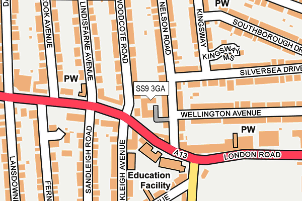
SS9 3GA lies on Howards Close in Leigh-on-sea. SS9 3GA is located in the Blenheim Park electoral ward, within the unitary authority of Southend-on-Sea and the English Parliamentary constituency of Southend West. The Sub Integrated Care Board (ICB) Location is NHS Mid and South Essex ICB - 99G and the police force is Essex. This postcode has been in use since April 2009.


GetTheData
Source: OS OpenMap – Local (Ordnance Survey)
Source: OS VectorMap District (Ordnance Survey)
Licence: Open Government Licence (requires attribution)
| Easting | 585374 |
| Northing | 186487 |
| Latitude | 51.546822 |
| Longitude | 0.672092 |
GetTheData
Source: Open Postcode Geo
Licence: Open Government Licence
| Street | Howards Close |
| Town/City | Leigh-on-sea |
| Country | England |
| Postcode District | SS9 |
➜ See where SS9 is on a map ➜ Where is Southend-on-Sea? | |
GetTheData
Source: Land Registry Price Paid Data
Licence: Open Government Licence
Elevation or altitude of SS9 3GA as distance above sea level:
| Metres | Feet | |
|---|---|---|
| Elevation | 30m | 98ft |
Elevation is measured from the approximate centre of the postcode, to the nearest point on an OS contour line from OS Terrain 50, which has contour spacing of ten vertical metres.
➜ How high above sea level am I? Find the elevation of your current position using your device's GPS.
GetTheData
Source: Open Postcode Elevation
Licence: Open Government Licence
| Ward | Blenheim Park |
| Constituency | Southend West |
GetTheData
Source: ONS Postcode Database
Licence: Open Government Licence
| Chalkwell Schools (London Road) | Leigh-on-sea | 85m |
| Chalkwell Schools (London Road) | Leigh-on-sea | 162m |
| Chalkwell Schools (Leigh Road) | Leigh-on-sea | 190m |
| Darlinghurst Grove (London Road) | Leigh-on-sea | 213m |
| Darlinghurst Grove (London Road) | Leigh-on-sea | 267m |
| Chalkwell Station | 0.9km |
| Westcliff-on-Sea Station | 1.7km |
| Leigh-on-Sea Station | 2.3km |
GetTheData
Source: NaPTAN
Licence: Open Government Licence
| Percentage of properties with Next Generation Access | 100.0% |
| Percentage of properties with Superfast Broadband | 100.0% |
| Percentage of properties with Ultrafast Broadband | 0.0% |
| Percentage of properties with Full Fibre Broadband | 0.0% |
Superfast Broadband is between 30Mbps and 300Mbps
Ultrafast Broadband is > 300Mbps
| Median download speed | 78.1Mbps |
| Average download speed | 56.8Mbps |
| Maximum download speed | 80.00Mbps |
| Median upload speed | 19.5Mbps |
| Average upload speed | 14.1Mbps |
| Maximum upload speed | 20.00Mbps |
| Percentage of properties unable to receive 2Mbps | 0.0% |
| Percentage of properties unable to receive 5Mbps | 0.0% |
| Percentage of properties unable to receive 10Mbps | 0.0% |
| Percentage of properties unable to receive 30Mbps | 0.0% |
GetTheData
Source: Ofcom
Licence: Ofcom Terms of Use (requires attribution)
GetTheData
Source: ONS Postcode Database
Licence: Open Government Licence


➜ Get more ratings from the Food Standards Agency
GetTheData
Source: Food Standards Agency
Licence: FSA terms & conditions
| Last Collection | |||
|---|---|---|---|
| Location | Mon-Fri | Sat | Distance |
| Garden Estate | 17:30 | 11:30 | 207m |
| Chalkwell Gardens | 17:30 | 11:30 | 284m |
| Holyrood Drive | 17:30 | 11:30 | 316m |
GetTheData
Source: Dracos
Licence: Creative Commons Attribution-ShareAlike
The below table lists the International Territorial Level (ITL) codes (formerly Nomenclature of Territorial Units for Statistics (NUTS) codes) and Local Administrative Units (LAU) codes for SS9 3GA:
| ITL 1 Code | Name |
|---|---|
| TLH | East |
| ITL 2 Code | Name |
| TLH3 | Essex |
| ITL 3 Code | Name |
| TLH31 | Southend-on-Sea |
| LAU 1 Code | Name |
| E06000033 | Southend-on-Sea |
GetTheData
Source: ONS Postcode Directory
Licence: Open Government Licence
The below table lists the Census Output Area (OA), Lower Layer Super Output Area (LSOA), and Middle Layer Super Output Area (MSOA) for SS9 3GA:
| Code | Name | |
|---|---|---|
| OA | E00079967 | |
| LSOA | E01015823 | Southend-on-Sea 005D |
| MSOA | E02003283 | Southend-on-Sea 005 |
GetTheData
Source: ONS Postcode Directory
Licence: Open Government Licence
| SS9 3LJ | London Road | 63m |
| SS9 3LL | London Road | 74m |
| SS9 3NL | London Road | 86m |
| SS9 3NP | Woodcote Road | 103m |
| SS9 3HU | Nelson Road | 108m |
| SS9 3HX | Nelson Road | 133m |
| SS0 9SZ | London Road | 153m |
| SS9 3NR | Lindisfarne Avenue | 160m |
| SS9 1FG | Ensign Close | 161m |
| SS0 9XF | Kingsway | 175m |
GetTheData
Source: Open Postcode Geo; Land Registry Price Paid Data
Licence: Open Government Licence