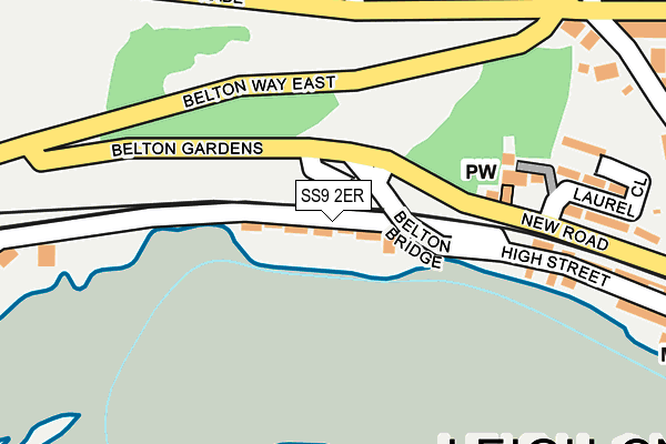
SS9 2ER is located in the Leigh electoral ward, within the unitary authority of Southend-on-Sea and the English Parliamentary constituency of Southend West. The Sub Integrated Care Board (ICB) Location is NHS Mid and South Essex ICB - 99G and the police force is Essex. This postcode has been in use since August 1992.


GetTheData
Source: OS OpenMap – Local (Ordnance Survey)
Source: OS VectorMap District (Ordnance Survey)
Licence: Open Government Licence (requires attribution)
| Easting | 583549 |
| Northing | 185781 |
| Latitude | 51.541077 |
| Longitude | 0.645434 |
GetTheData
Source: Open Postcode Geo
Licence: Open Government Licence
| Country | England |
| Postcode District | SS9 |
➜ See where SS9 is on a map ➜ Where is Southend-on-Sea? | |
GetTheData
Source: Land Registry Price Paid Data
Licence: Open Government Licence
Elevation or altitude of SS9 2ER as distance above sea level:
| Metres | Feet | |
|---|---|---|
| Elevation | 10m | 33ft |
Elevation is measured from the approximate centre of the postcode, to the nearest point on an OS contour line from OS Terrain 50, which has contour spacing of ten vertical metres.
➜ How high above sea level am I? Find the elevation of your current position using your device's GPS.
GetTheData
Source: Open Postcode Elevation
Licence: Open Government Licence
| Ward | Leigh |
| Constituency | Southend West |
GetTheData
Source: ONS Postcode Database
Licence: Open Government Licence
| Belton Way East (Rectory Grove) | Leigh-on-sea | 312m |
| Belton Way East (Rectory Grove) | Leigh-on-sea | 341m |
| Grange Road (Hadleigh Road) | Leigh-on-sea | 345m |
| Leigh-on-sea Railway Station (Belton Way West) | Leigh-on-sea | 351m |
| Leigh-on-sea Railway Station (Belton Way West) | Leigh-on-sea | 355m |
| Leigh-on-Sea Station | 0.3km |
| Chalkwell Station | 1.8km |
| Westcliff-on-Sea Station | 3.2km |
GetTheData
Source: NaPTAN
Licence: Open Government Licence
GetTheData
Source: ONS Postcode Database
Licence: Open Government Licence


➜ Get more ratings from the Food Standards Agency
GetTheData
Source: Food Standards Agency
Licence: FSA terms & conditions
| Last Collection | |||
|---|---|---|---|
| Location | Mon-Fri | Sat | Distance |
| Belton Corner | 17:30 | 11:30 | 287m |
| Theobalds Road | 17:30 | 11:30 | 295m |
| Leigh Railway Station | 17:30 | 11:30 | 346m |
GetTheData
Source: Dracos
Licence: Creative Commons Attribution-ShareAlike
The below table lists the International Territorial Level (ITL) codes (formerly Nomenclature of Territorial Units for Statistics (NUTS) codes) and Local Administrative Units (LAU) codes for SS9 2ER:
| ITL 1 Code | Name |
|---|---|
| TLH | East |
| ITL 2 Code | Name |
| TLH3 | Essex |
| ITL 3 Code | Name |
| TLH31 | Southend-on-Sea |
| LAU 1 Code | Name |
| E06000033 | Southend-on-Sea |
GetTheData
Source: ONS Postcode Directory
Licence: Open Government Licence
The below table lists the Census Output Area (OA), Lower Layer Super Output Area (LSOA), and Middle Layer Super Output Area (MSOA) for SS9 2ER:
| Code | Name | |
|---|---|---|
| OA | E00080104 | |
| LSOA | E01015848 | Southend-on-Sea 011D |
| MSOA | E02003289 | Southend-on-Sea 011 |
GetTheData
Source: ONS Postcode Directory
Licence: Open Government Licence
| SS9 2EH | Billet Lane | 160m |
| SS9 2EF | Billet Lane | 171m |
| SS9 2EQ | Billet Lane | 174m |
| SS9 2NA | Marine Parade | 224m |
| SS9 2EB | New Road | 235m |
| SS9 2EE | Laurel Close | 238m |
| SS9 2HR | Billet Lane | 263m |
| SS9 2HP | Belton Corner | 275m |
| SS9 2EP | High Street | 276m |
| SS9 2NB | Marine Parade | 280m |
GetTheData
Source: Open Postcode Geo; Land Registry Price Paid Data
Licence: Open Government Licence