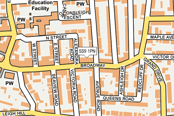
SS9 1PN is located in the Leigh electoral ward, within the unitary authority of Southend-on-Sea and the English Parliamentary constituency of Southend West. The Sub Integrated Care Board (ICB) Location is NHS Mid and South Essex ICB - 99G and the police force is Essex. This postcode has been in use since January 1980.


GetTheData
Source: OS OpenMap – Local (Ordnance Survey)
Source: OS VectorMap District (Ordnance Survey)
Licence: Open Government Licence (requires attribution)
| Easting | 584424 |
| Northing | 185891 |
| Latitude | 51.541780 |
| Longitude | 0.658094 |
GetTheData
Source: Open Postcode Geo
Licence: Open Government Licence
| Country | England |
| Postcode District | SS9 |
➜ See where SS9 is on a map ➜ Where is Southend-on-Sea? | |
GetTheData
Source: Land Registry Price Paid Data
Licence: Open Government Licence
Elevation or altitude of SS9 1PN as distance above sea level:
| Metres | Feet | |
|---|---|---|
| Elevation | 30m | 98ft |
Elevation is measured from the approximate centre of the postcode, to the nearest point on an OS contour line from OS Terrain 50, which has contour spacing of ten vertical metres.
➜ How high above sea level am I? Find the elevation of your current position using your device's GPS.
GetTheData
Source: Open Postcode Elevation
Licence: Open Government Licence
| Ward | Leigh |
| Constituency | Southend West |
GetTheData
Source: ONS Postcode Database
Licence: Open Government Licence
| Leighton Avenue (Broadway) | Leigh-on-sea | 113m |
| Redcliff Drive (Broadway) | Leigh-on-sea | 114m |
| Broadway | Leigh-on-sea | 150m |
| Leigh Church (Broadway West) | Leigh-on-sea | 322m |
| Chalkwell Park Drive (Leigh Road) | Leigh-on-sea | 326m |
| Chalkwell Station | 0.9km |
| Leigh-on-Sea Station | 1.2km |
| Westcliff-on-Sea Station | 2.4km |
GetTheData
Source: NaPTAN
Licence: Open Government Licence
GetTheData
Source: ONS Postcode Database
Licence: Open Government Licence


➜ Get more ratings from the Food Standards Agency
GetTheData
Source: Food Standards Agency
Licence: FSA terms & conditions
| Last Collection | |||
|---|---|---|---|
| Location | Mon-Fri | Sat | Distance |
| The Broadway | 17:30 | 11:30 | 126m |
| 37 West Street | 17:30 | 11:30 | 176m |
| Pall Mall | 17:30 | 11:30 | 223m |
GetTheData
Source: Dracos
Licence: Creative Commons Attribution-ShareAlike
The below table lists the International Territorial Level (ITL) codes (formerly Nomenclature of Territorial Units for Statistics (NUTS) codes) and Local Administrative Units (LAU) codes for SS9 1PN:
| ITL 1 Code | Name |
|---|---|
| TLH | East |
| ITL 2 Code | Name |
| TLH3 | Essex |
| ITL 3 Code | Name |
| TLH31 | Southend-on-Sea |
| LAU 1 Code | Name |
| E06000033 | Southend-on-Sea |
GetTheData
Source: ONS Postcode Directory
Licence: Open Government Licence
The below table lists the Census Output Area (OA), Lower Layer Super Output Area (LSOA), and Middle Layer Super Output Area (MSOA) for SS9 1PN:
| Code | Name | |
|---|---|---|
| OA | E00080129 | |
| LSOA | E01015847 | Southend-on-Sea 011C |
| MSOA | E02003289 | Southend-on-Sea 011 |
GetTheData
Source: ONS Postcode Directory
Licence: Open Government Licence
| SS9 1QD | Alexandra Road | 41m |
| SS9 1PE | Broadway | 46m |
| SS9 1AG | Broadway | 46m |
| SS9 1PG | Broadway | 82m |
| SS9 1AE | Broadway | 87m |
| SS9 1AJ | Broadway | 94m |
| SS9 1RL | Leigh Hall Road | 94m |
| SS9 1AX | Avenue Road | 97m |
| SS9 1QF | East Street | 99m |
| SS9 1RN | Leigh Hall Road | 101m |
GetTheData
Source: Open Postcode Geo; Land Registry Price Paid Data
Licence: Open Government Licence