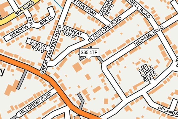
SS5 4TP lies on Hawks Lane in Hockley. SS5 4TP is located in the Hockley electoral ward, within the local authority district of Rochford and the English Parliamentary constituency of Rayleigh and Wickford. The Sub Integrated Care Board (ICB) Location is NHS Mid and South Essex ICB - 99F and the police force is Essex. This postcode has been in use since June 1996.


GetTheData
Source: OS OpenMap – Local (Ordnance Survey)
Source: OS VectorMap District (Ordnance Survey)
Licence: Open Government Licence (requires attribution)
| Easting | 584347 |
| Northing | 192420 |
| Latitude | 51.600447 |
| Longitude | 0.660408 |
GetTheData
Source: Open Postcode Geo
Licence: Open Government Licence
| Street | Hawks Lane |
| Town/City | Hockley |
| Country | England |
| Postcode District | SS5 |
➜ See where SS5 is on a map ➜ Where is Hockley? | |
GetTheData
Source: Land Registry Price Paid Data
Licence: Open Government Licence
Elevation or altitude of SS5 4TP as distance above sea level:
| Metres | Feet | |
|---|---|---|
| Elevation | 50m | 164ft |
Elevation is measured from the approximate centre of the postcode, to the nearest point on an OS contour line from OS Terrain 50, which has contour spacing of ten vertical metres.
➜ How high above sea level am I? Find the elevation of your current position using your device's GPS.
GetTheData
Source: Open Postcode Elevation
Licence: Open Government Licence
| Ward | Hockley |
| Constituency | Rayleigh And Wickford |
GetTheData
Source: ONS Postcode Database
Licence: Open Government Licence
2, HAWKS LANE, HOCKLEY, SS5 4TP 2020 11 NOV £492,500 |
2010 19 MAR £335,000 |
3, HAWKS LANE, HOCKLEY, SS5 4TP 2001 20 AUG £247,000 |
4, HAWKS LANE, HOCKLEY, SS5 4TP 1997 14 FEB £139,995 |
3, HAWKS LANE, HOCKLEY, SS5 4TP 1996 19 AUG £139,995 |
1996 31 MAY £135,000 |
GetTheData
Source: HM Land Registry Price Paid Data
Licence: Contains HM Land Registry data © Crown copyright and database right 2025. This data is licensed under the Open Government Licence v3.0.
| Great Eastern Road | Hockley | 135m |
| Great Eastern Road | Hockley | 143m |
| The White Hart (Main Road) | Hawkwell | 206m |
| The White Hart (Main Road) | Hawkwell | 243m |
| Station Approach (Station Road) | Hockley | 248m |
| Hockley Station | 0.4km |
| Rochford Station | 3.6km |
| Rayleigh Station | 4.4km |
GetTheData
Source: NaPTAN
Licence: Open Government Licence
| Percentage of properties with Next Generation Access | 100.0% |
| Percentage of properties with Superfast Broadband | 100.0% |
| Percentage of properties with Ultrafast Broadband | 0.0% |
| Percentage of properties with Full Fibre Broadband | 0.0% |
Superfast Broadband is between 30Mbps and 300Mbps
Ultrafast Broadband is > 300Mbps
| Percentage of properties unable to receive 2Mbps | 0.0% |
| Percentage of properties unable to receive 5Mbps | 0.0% |
| Percentage of properties unable to receive 10Mbps | 0.0% |
| Percentage of properties unable to receive 30Mbps | 0.0% |
GetTheData
Source: Ofcom
Licence: Ofcom Terms of Use (requires attribution)
GetTheData
Source: ONS Postcode Database
Licence: Open Government Licence


➜ Get more ratings from the Food Standards Agency
GetTheData
Source: Food Standards Agency
Licence: FSA terms & conditions
| Last Collection | |||
|---|---|---|---|
| Location | Mon-Fri | Sat | Distance |
| Station Approach | 17:30 | 09:00 | 283m |
| Hockley Delivery Office | 17:30 | 12:30 | 315m |
| 69 Southend Road | 17:00 | 09:00 | 404m |
GetTheData
Source: Dracos
Licence: Creative Commons Attribution-ShareAlike
The below table lists the International Territorial Level (ITL) codes (formerly Nomenclature of Territorial Units for Statistics (NUTS) codes) and Local Administrative Units (LAU) codes for SS5 4TP:
| ITL 1 Code | Name |
|---|---|
| TLH | East |
| ITL 2 Code | Name |
| TLH3 | Essex |
| ITL 3 Code | Name |
| TLH37 | Essex Thames Gateway |
| LAU 1 Code | Name |
| E07000075 | Rochford |
GetTheData
Source: ONS Postcode Directory
Licence: Open Government Licence
The below table lists the Census Output Area (OA), Lower Layer Super Output Area (LSOA), and Middle Layer Super Output Area (MSOA) for SS5 4TP:
| Code | Name | |
|---|---|---|
| OA | E00111430 | |
| LSOA | E01021936 | Rochford 003D |
| MSOA | E02004565 | Rochford 003 |
GetTheData
Source: ONS Postcode Directory
Licence: Open Government Licence
| SS5 4BT | Gladstone Road | 49m |
| SS5 4BS | Gladstone Road | 98m |
| SS5 4BU | Retreat Road | 101m |
| SS5 4DG | Highams Road | 125m |
| SS5 4QQ | Southend Road | 127m |
| SS5 4QR | Hawkley Meade | 150m |
| SS5 4BX | Great Eastern Road | 154m |
| SS5 4ED | Kent Green Close | 167m |
| SS5 4LX | Southend Road | 171m |
| SS5 4BZ | Station Road | 171m |
GetTheData
Source: Open Postcode Geo; Land Registry Price Paid Data
Licence: Open Government Licence