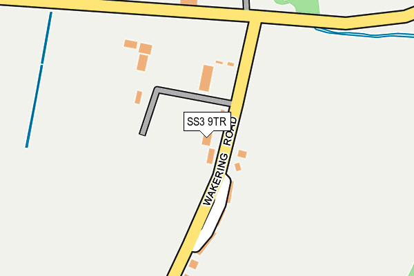
SS3 9TR lies on Wakering Road in Shoeburyness, Southend-on-sea. SS3 9TR is located in the Foulness and The Wakerings electoral ward, within the local authority district of Rochford and the English Parliamentary constituency of Rochford and Southend East. The Sub Integrated Care Board (ICB) Location is NHS Mid and South Essex ICB - 99F and the police force is Essex. This postcode has been in use since January 1980.


GetTheData
Source: OS OpenMap – Local (Ordnance Survey)
Source: OS VectorMap District (Ordnance Survey)
Licence: Open Government Licence (requires attribution)
| Easting | 594613 |
| Northing | 186436 |
| Latitude | 51.543261 |
| Longitude | 0.805172 |
GetTheData
Source: Open Postcode Geo
Licence: Open Government Licence
| Street | Wakering Road |
| Locality | Shoeburyness |
| Town/City | Southend-on-sea |
| Country | England |
| Postcode District | SS3 |
➜ See where SS3 is on a map ➜ Where is Shoeburyness? | |
GetTheData
Source: Land Registry Price Paid Data
Licence: Open Government Licence
Elevation or altitude of SS3 9TR as distance above sea level:
| Metres | Feet | |
|---|---|---|
| Elevation | 10m | 33ft |
Elevation is measured from the approximate centre of the postcode, to the nearest point on an OS contour line from OS Terrain 50, which has contour spacing of ten vertical metres.
➜ How high above sea level am I? Find the elevation of your current position using your device's GPS.
GetTheData
Source: Open Postcode Elevation
Licence: Open Government Licence
| Ward | Foulness And The Wakerings |
| Constituency | Rochford And Southend East |
GetTheData
Source: ONS Postcode Database
Licence: Open Government Licence
| Mod Houses (Wakering Road) | Great Wakering | 121m |
| Mod Houses (Wakering Road) | Great Wakering | 125m |
| Landsdowne Corner (Wakering Road) | Great Wakering | 162m |
| Landsdowne Corner (Poynters Lane) | Great Wakering | 210m |
| Constable Way (Wakering Road) | North Shoebury | 542m |
| Shoeburyness Station | 1.5km |
| Thorpe Bay Station | 3.1km |
GetTheData
Source: NaPTAN
Licence: Open Government Licence
| Percentage of properties with Next Generation Access | 0.0% |
| Percentage of properties with Superfast Broadband | 0.0% |
| Percentage of properties with Ultrafast Broadband | 0.0% |
| Percentage of properties with Full Fibre Broadband | 0.0% |
Superfast Broadband is between 30Mbps and 300Mbps
Ultrafast Broadband is > 300Mbps
| Percentage of properties unable to receive 2Mbps | 0.0% |
| Percentage of properties unable to receive 5Mbps | 0.0% |
| Percentage of properties unable to receive 10Mbps | 0.0% |
| Percentage of properties unable to receive 30Mbps | 100.0% |
GetTheData
Source: Ofcom
Licence: Ofcom Terms of Use (requires attribution)
GetTheData
Source: ONS Postcode Database
Licence: Open Government Licence


➜ Get more ratings from the Food Standards Agency
GetTheData
Source: Food Standards Agency
Licence: FSA terms & conditions
| Last Collection | |||
|---|---|---|---|
| Location | Mon-Fri | Sat | Distance |
| Constable Way | 17:00 | 10:30 | 633m |
| Seaview Road | 16:45 | 10:30 | 692m |
| The Renown Post Office | 17:00 | 12:00 | 915m |
GetTheData
Source: Dracos
Licence: Creative Commons Attribution-ShareAlike
The below table lists the International Territorial Level (ITL) codes (formerly Nomenclature of Territorial Units for Statistics (NUTS) codes) and Local Administrative Units (LAU) codes for SS3 9TR:
| ITL 1 Code | Name |
|---|---|
| TLH | East |
| ITL 2 Code | Name |
| TLH3 | Essex |
| ITL 3 Code | Name |
| TLH37 | Essex Thames Gateway |
| LAU 1 Code | Name |
| E07000075 | Rochford |
GetTheData
Source: ONS Postcode Directory
Licence: Open Government Licence
The below table lists the Census Output Area (OA), Lower Layer Super Output Area (LSOA), and Middle Layer Super Output Area (MSOA) for SS3 9TR:
| Code | Name | |
|---|---|---|
| OA | E00111349 | |
| LSOA | E01021921 | Rochford 010B |
| MSOA | E02004572 | Rochford 010 |
GetTheData
Source: ONS Postcode Directory
Licence: Open Government Licence
| SS3 9TP | Wakering Road | 119m |
| SS3 9TS | Poynters Lane | 281m |
| SS3 9UZ | Picasso Way | 320m |
| SS3 9TW | Wakering Road | 341m |
| SS3 9UY | Picasso Way | 422m |
| SS3 9XB | Picasso Way | 423m |
| SS3 0AY | Poynters Lane | 434m |
| SS3 9XA | Picasso Way | 453m |
| SS3 9TN | Wakering Road | 508m |
| SS3 9TD | Picasso Way | 579m |
GetTheData
Source: Open Postcode Geo; Land Registry Price Paid Data
Licence: Open Government Licence