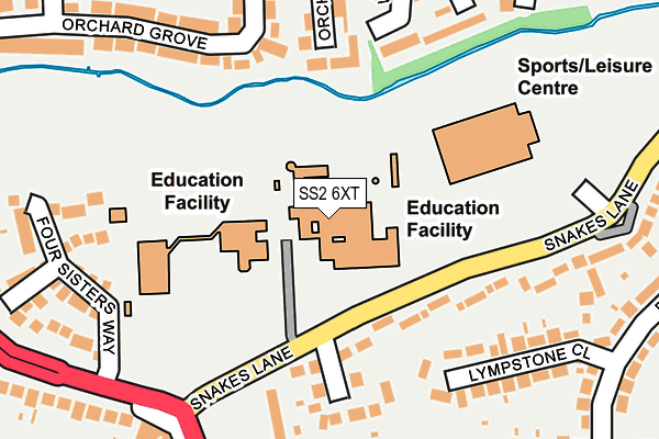
SS2 6XT lies on Snakes Lane in Southend-on-sea. SS2 6XT is located in the St Laurence electoral ward, within the unitary authority of Southend-on-Sea and the English Parliamentary constituency of Southend West. The Sub Integrated Care Board (ICB) Location is NHS Mid and South Essex ICB - 99G and the police force is Essex. This postcode has been in use since January 1980.


GetTheData
Source: OS OpenMap – Local (Ordnance Survey)
Source: OS VectorMap District (Ordnance Survey)
Licence: Open Government Licence (requires attribution)
| Easting | 584979 |
| Northing | 188532 |
| Latitude | 51.565319 |
| Longitude | 0.667476 |
GetTheData
Source: Open Postcode Geo
Licence: Open Government Licence
| Street | Snakes Lane |
| Town/City | Southend-on-sea |
| Country | England |
| Postcode District | SS2 |
➜ See where SS2 is on a map ➜ Where is Southend-on-Sea? | |
GetTheData
Source: Land Registry Price Paid Data
Licence: Open Government Licence
Elevation or altitude of SS2 6XT as distance above sea level:
| Metres | Feet | |
|---|---|---|
| Elevation | 20m | 66ft |
Elevation is measured from the approximate centre of the postcode, to the nearest point on an OS contour line from OS Terrain 50, which has contour spacing of ten vertical metres.
➜ How high above sea level am I? Find the elevation of your current position using your device's GPS.
GetTheData
Source: Open Postcode Elevation
Licence: Open Government Licence
| Ward | St Laurence |
| Constituency | Southend West |
GetTheData
Source: ONS Postcode Database
Licence: Open Government Licence
| David Lloyd (Snakes Lane) | Eastwood | 163m |
| Kent Elms Corner North (Rayleigh Road) | Leigh-on-sea | 220m |
| David Lloyd (Snakes Lane) | Eastwood | 226m |
| Kent Elms Corner North (Rayleigh Road) | Leigh-on-sea | 279m |
| Brendon Way (Prince Avenue) | Prittlewell | 322m |
| Southend Airport Station | 2.6km |
| Chalkwell Station | 3km |
| Rochford Station | 3km |
GetTheData
Source: NaPTAN
Licence: Open Government Licence
GetTheData
Source: ONS Postcode Database
Licence: Open Government Licence


➜ Get more ratings from the Food Standards Agency
GetTheData
Source: Food Standards Agency
Licence: FSA terms & conditions
| Last Collection | |||
|---|---|---|---|
| Location | Mon-Fri | Sat | Distance |
| Snakes Lane | 17:30 | 11:30 | 229m |
| Brendon Way | 17:30 | 11:30 | 294m |
| Eastwood Rise | 17:30 | 11:30 | 301m |
GetTheData
Source: Dracos
Licence: Creative Commons Attribution-ShareAlike
The below table lists the International Territorial Level (ITL) codes (formerly Nomenclature of Territorial Units for Statistics (NUTS) codes) and Local Administrative Units (LAU) codes for SS2 6XT:
| ITL 1 Code | Name |
|---|---|
| TLH | East |
| ITL 2 Code | Name |
| TLH3 | Essex |
| ITL 3 Code | Name |
| TLH31 | Southend-on-Sea |
| LAU 1 Code | Name |
| E06000033 | Southend-on-Sea |
GetTheData
Source: ONS Postcode Directory
Licence: Open Government Licence
The below table lists the Census Output Area (OA), Lower Layer Super Output Area (LSOA), and Middle Layer Super Output Area (MSOA) for SS2 6XT:
| Code | Name | |
|---|---|---|
| OA | E00080233 | |
| LSOA | E01015863 | Southend-on-Sea 002A |
| MSOA | E02003280 | Southend-on-Sea 002 |
GetTheData
Source: ONS Postcode Directory
Licence: Open Government Licence
| SS2 6UA | Snakes Lane | 144m |
| SS2 6UB | Kent Elms Close | 179m |
| SS0 0JE | Lympstone Close | 192m |
| SS9 5TR | Orchard Grove | 216m |
| SS9 5TT | Orchard Side | 225m |
| SS0 0JB | Prince Avenue | 230m |
| SS9 5FQ | Four Sisters Way | 232m |
| SS9 5TP | Orchard Grove | 250m |
| SS9 5TY | Whitehouse Meadows | 256m |
| SS9 5TZ | Whitehouse Meadows | 268m |
GetTheData
Source: Open Postcode Geo; Land Registry Price Paid Data
Licence: Open Government Licence