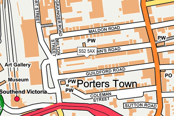
SS2 5AX lies on Carlton Villas in Southend-on-sea. SS2 5AX is located in the Victoria electoral ward, within the unitary authority of Southend-on-Sea and the English Parliamentary constituency of Rochford and Southend East. The Sub Integrated Care Board (ICB) Location is NHS Mid and South Essex ICB - 99G and the police force is Essex. This postcode has been in use since January 1980.


GetTheData
Source: OS OpenMap – Local (Ordnance Survey)
Source: OS VectorMap District (Ordnance Survey)
Licence: Open Government Licence (requires attribution)
| Easting | 588376 |
| Northing | 186160 |
| Latitude | 51.542892 |
| Longitude | 0.715160 |
GetTheData
Source: Open Postcode Geo
Licence: Open Government Licence
| Street | Carlton Villas |
| Town/City | Southend-on-sea |
| Country | England |
| Postcode District | SS2 |
➜ See where SS2 is on a map ➜ Where is Southend-on-Sea? | |
GetTheData
Source: Land Registry Price Paid Data
Licence: Open Government Licence
Elevation or altitude of SS2 5AX as distance above sea level:
| Metres | Feet | |
|---|---|---|
| Elevation | 20m | 66ft |
Elevation is measured from the approximate centre of the postcode, to the nearest point on an OS contour line from OS Terrain 50, which has contour spacing of ten vertical metres.
➜ How high above sea level am I? Find the elevation of your current position using your device's GPS.
GetTheData
Source: Open Postcode Elevation
Licence: Open Government Licence
| Ward | Victoria |
| Constituency | Rochford And Southend East |
GetTheData
Source: ONS Postcode Database
Licence: Open Government Licence
| Guildford Road (Sutton Road) | Southchurch | 232m |
| Welfares (Sutton Road) | Southchurch | 241m |
| Chichester Road | Southend-on-sea | 253m |
| Victoria Station Interchange (Queensway) | Southend-on-sea | 257m |
| Victoria Station Interchange (Queensway) | Southend-on-sea | 265m |
| Southend Victoria Station | 0.3km |
| Southend Central Station | 0.7km |
| Prittlewell Station | 0.9km |
GetTheData
Source: NaPTAN
Licence: Open Government Licence
| Percentage of properties with Next Generation Access | 100.0% |
| Percentage of properties with Superfast Broadband | 100.0% |
| Percentage of properties with Ultrafast Broadband | 100.0% |
| Percentage of properties with Full Fibre Broadband | 0.0% |
Superfast Broadband is between 30Mbps and 300Mbps
Ultrafast Broadband is > 300Mbps
| Percentage of properties unable to receive 2Mbps | 0.0% |
| Percentage of properties unable to receive 5Mbps | 0.0% |
| Percentage of properties unable to receive 10Mbps | 0.0% |
| Percentage of properties unable to receive 30Mbps | 0.0% |
GetTheData
Source: Ofcom
Licence: Ofcom Terms of Use (requires attribution)
GetTheData
Source: ONS Postcode Database
Licence: Open Government Licence


➜ Get more ratings from the Food Standards Agency
GetTheData
Source: Food Standards Agency
Licence: FSA terms & conditions
| Last Collection | |||
|---|---|---|---|
| Location | Mon-Fri | Sat | Distance |
| Sutton Road Post Office | 18:30 | 12:00 | 253m |
| Southchurch Road | 18:30 | 11:30 | 289m |
| Warrior Square | 18:30 | 11:30 | 350m |
GetTheData
Source: Dracos
Licence: Creative Commons Attribution-ShareAlike
The below table lists the International Territorial Level (ITL) codes (formerly Nomenclature of Territorial Units for Statistics (NUTS) codes) and Local Administrative Units (LAU) codes for SS2 5AX:
| ITL 1 Code | Name |
|---|---|
| TLH | East |
| ITL 2 Code | Name |
| TLH3 | Essex |
| ITL 3 Code | Name |
| TLH31 | Southend-on-Sea |
| LAU 1 Code | Name |
| E06000033 | Southend-on-Sea |
GetTheData
Source: ONS Postcode Directory
Licence: Open Government Licence
The below table lists the Census Output Area (OA), Lower Layer Super Output Area (LSOA), and Middle Layer Super Output Area (MSOA) for SS2 5AX:
| Code | Name | |
|---|---|---|
| OA | E00080376 | |
| LSOA | E01015895 | Southend-on-Sea 010A |
| MSOA | E02003288 | Southend-on-Sea 010 |
GetTheData
Source: ONS Postcode Directory
Licence: Open Government Licence
| SS2 5AR | Guildford Road | 48m |
| SS2 5AU | St Anns Road | 54m |
| SS2 5AT | St Anns Road | 60m |
| SS2 5BS | Milton Close | 65m |
| SS2 5AZ | Maldon Road | 75m |
| SS2 5AS | Guildford Road | 77m |
| SS2 5BJ | Guildford Road | 94m |
| SS2 5BU | Milton Street | 104m |
| SS2 5AL | Prittlewell Street | 110m |
| SS2 5AY | Maldon Road | 115m |
GetTheData
Source: Open Postcode Geo; Land Registry Price Paid Data
Licence: Open Government Licence