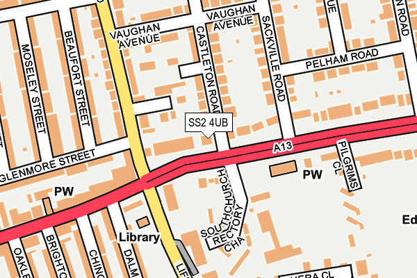
SS2 4UB lies on Southchurch Boulevard in Southend-on-sea. SS2 4UB is located in the Southchurch electoral ward, within the unitary authority of Southend-on-Sea and the English Parliamentary constituency of Rochford and Southend East. The Sub Integrated Care Board (ICB) Location is NHS Mid and South Essex ICB - 99G and the police force is Essex. This postcode has been in use since January 1980.


GetTheData
Source: OS OpenMap – Local (Ordnance Survey)
Source: OS VectorMap District (Ordnance Survey)
Licence: Open Government Licence (requires attribution)
| Easting | 590069 |
| Northing | 186145 |
| Latitude | 51.542190 |
| Longitude | 0.739537 |
GetTheData
Source: Open Postcode Geo
Licence: Open Government Licence
| Street | Southchurch Boulevard |
| Town/City | Southend-on-sea |
| Country | England |
| Postcode District | SS2 |
➜ See where SS2 is on a map ➜ Where is Southend-on-Sea? | |
GetTheData
Source: Land Registry Price Paid Data
Licence: Open Government Licence
Elevation or altitude of SS2 4UB as distance above sea level:
| Metres | Feet | |
|---|---|---|
| Elevation | 20m | 66ft |
Elevation is measured from the approximate centre of the postcode, to the nearest point on an OS contour line from OS Terrain 50, which has contour spacing of ten vertical metres.
➜ How high above sea level am I? Find the elevation of your current position using your device's GPS.
GetTheData
Source: Open Postcode Elevation
Licence: Open Government Licence
| Ward | Southchurch |
| Constituency | Rochford And Southend East |
GetTheData
Source: ONS Postcode Database
Licence: Open Government Licence
27, SOUTHCHURCH BOULEVARD, SOUTHEND-ON-SEA, SS2 4UB 2010 21 JUN £330,000 |
➜ Southend-on-Sea house prices
GetTheData
Source: HM Land Registry Price Paid Data
Licence: Contains HM Land Registry data © Crown copyright and database right 2025. This data is licensed under the Open Government Licence v3.0.
| The White Horse Ph (Southchurch Boulevard) | Southchurch | 64m |
| The White Horse Ph (Lifstan Way) | Southchurch | 115m |
| The White Horse Ph (Hamstel Road) | Southchurch | 123m |
| The White Horse Ph (Southchurch Road) | Southchurch | 146m |
| Stornoway Road (Hamstel Road) | Southchurch | 284m |
| Southend East Station | 0.6km |
| Thorpe Bay Station | 1.6km |
| Southend Victoria Station | 1.9km |
GetTheData
Source: NaPTAN
Licence: Open Government Licence
GetTheData
Source: ONS Postcode Database
Licence: Open Government Licence


➜ Get more ratings from the Food Standards Agency
GetTheData
Source: Food Standards Agency
Licence: FSA terms & conditions
| Last Collection | |||
|---|---|---|---|
| Location | Mon-Fri | Sat | Distance |
| Sackville Road | 17:30 | 11:30 | 110m |
| The Strand Post Office | 17:30 | 11:30 | 252m |
| Richmond Street | 17:30 | 11:30 | 367m |
GetTheData
Source: Dracos
Licence: Creative Commons Attribution-ShareAlike
The below table lists the International Territorial Level (ITL) codes (formerly Nomenclature of Territorial Units for Statistics (NUTS) codes) and Local Administrative Units (LAU) codes for SS2 4UB:
| ITL 1 Code | Name |
|---|---|
| TLH | East |
| ITL 2 Code | Name |
| TLH3 | Essex |
| ITL 3 Code | Name |
| TLH31 | Southend-on-Sea |
| LAU 1 Code | Name |
| E06000033 | Southend-on-Sea |
GetTheData
Source: ONS Postcode Directory
Licence: Open Government Licence
The below table lists the Census Output Area (OA), Lower Layer Super Output Area (LSOA), and Middle Layer Super Output Area (MSOA) for SS2 4UB:
| Code | Name | |
|---|---|---|
| OA | E00080332 | |
| LSOA | E01015884 | Southend-on-Sea 009B |
| MSOA | E02003287 | Southend-on-Sea 009 |
GetTheData
Source: ONS Postcode Directory
Licence: Open Government Licence
| SS2 4UA | Southchurch Boulevard | 43m |
| SS2 4TZ | Pavilion Close | 90m |
| SS2 4UD | Castleton Road | 94m |
| SS2 4PG | Droitwich Avenue | 96m |
| SS2 4UQ | Sackville Road | 137m |
| SS2 4XB | Southchurch Rectory Chase | 138m |
| SS2 4PL | Hamstel Mews | 144m |
| SS2 4XE | Southchurch Rectory Chase | 151m |
| SS2 4XA | Southchurch Boulevard | 165m |
| SS2 4PF | Hamstel Road | 168m |
GetTheData
Source: Open Postcode Geo; Land Registry Price Paid Data
Licence: Open Government Licence