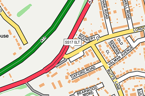
SS17 0LT lies on London Road in Stanford-le-hope. SS17 0LT is located in the Stanford-le-Hope West electoral ward, within the unitary authority of Thurrock and the English Parliamentary constituency of South Basildon and East Thurrock. The Sub Integrated Care Board (ICB) Location is NHS Mid and South Essex ICB - 07G and the police force is Essex. This postcode has been in use since January 1980.


GetTheData
Source: OS OpenMap – Local (Ordnance Survey)
Source: OS VectorMap District (Ordnance Survey)
Licence: Open Government Licence (requires attribution)
| Easting | 567649 |
| Northing | 182130 |
| Latitude | 51.513223 |
| Longitude | 0.414675 |
GetTheData
Source: Open Postcode Geo
Licence: Open Government Licence
| Street | London Road |
| Town/City | Stanford-le-hope |
| Country | England |
| Postcode District | SS17 |
➜ See where SS17 is on a map ➜ Where is Stanford-le-Hope? | |
GetTheData
Source: Land Registry Price Paid Data
Licence: Open Government Licence
Elevation or altitude of SS17 0LT as distance above sea level:
| Metres | Feet | |
|---|---|---|
| Elevation | 10m | 33ft |
Elevation is measured from the approximate centre of the postcode, to the nearest point on an OS contour line from OS Terrain 50, which has contour spacing of ten vertical metres.
➜ How high above sea level am I? Find the elevation of your current position using your device's GPS.
GetTheData
Source: Open Postcode Elevation
Licence: Open Government Licence
| Ward | Stanford-le-hope West |
| Constituency | South Basildon And East Thurrock |
GetTheData
Source: ONS Postcode Database
Licence: Open Government Licence
| Butts Lane (London Road) | Stanford Le Hope | 37m |
| Butts Lane (London Road) | Stanford Le Hope | 149m |
| Rookery Corner (London Road) | Stanford Le Hope | 162m |
| Rookery Corner (London Road) | Stanford Le Hope | 229m |
| St Clere's School (Butts Lane) | Stanford Le Hope | 438m |
| Stanford-le-Hope Station | 0.6km |
| East Tilbury Station | 3.2km |
GetTheData
Source: NaPTAN
Licence: Open Government Licence
| Percentage of properties with Next Generation Access | 100.0% |
| Percentage of properties with Superfast Broadband | 100.0% |
| Percentage of properties with Ultrafast Broadband | 0.0% |
| Percentage of properties with Full Fibre Broadband | 0.0% |
Superfast Broadband is between 30Mbps and 300Mbps
Ultrafast Broadband is > 300Mbps
| Percentage of properties unable to receive 2Mbps | 0.0% |
| Percentage of properties unable to receive 5Mbps | 0.0% |
| Percentage of properties unable to receive 10Mbps | 0.0% |
| Percentage of properties unable to receive 30Mbps | 0.0% |
GetTheData
Source: Ofcom
Licence: Ofcom Terms of Use (requires attribution)
GetTheData
Source: ONS Postcode Database
Licence: Open Government Licence


➜ Get more ratings from the Food Standards Agency
GetTheData
Source: Food Standards Agency
Licence: FSA terms & conditions
| Last Collection | |||
|---|---|---|---|
| Location | Mon-Fri | Sat | Distance |
| Valmar Avenue | 16:15 | 11:30 | 169m |
| London Road | 16:15 | 11:30 | 417m |
| First Avenue | 16:45 | 11:30 | 1,533m |
GetTheData
Source: Dracos
Licence: Creative Commons Attribution-ShareAlike
The below table lists the International Territorial Level (ITL) codes (formerly Nomenclature of Territorial Units for Statistics (NUTS) codes) and Local Administrative Units (LAU) codes for SS17 0LT:
| ITL 1 Code | Name |
|---|---|
| TLH | East |
| ITL 2 Code | Name |
| TLH3 | Essex |
| ITL 3 Code | Name |
| TLH32 | Thurrock |
| LAU 1 Code | Name |
| E06000034 | Thurrock |
GetTheData
Source: ONS Postcode Directory
Licence: Open Government Licence
The below table lists the Census Output Area (OA), Lower Layer Super Output Area (LSOA), and Middle Layer Super Output Area (MSOA) for SS17 0LT:
| Code | Name | |
|---|---|---|
| OA | E00080847 | |
| LSOA | E01015991 | Thurrock 005B |
| MSOA | E02003300 | Thurrock 005 |
GetTheData
Source: ONS Postcode Directory
Licence: Open Government Licence
| SS17 0LY | London Road | 68m |
| SS17 0LS | Rookery Close | 76m |
| SS17 0NA | Oxford Road | 105m |
| SS17 0LZ | Butts Lane | 134m |
| SS17 0NB | Old Jenkins Close | 170m |
| SS17 0FH | Bearwood Road | 186m |
| SS17 0LX | London Road | 198m |
| SS17 0FG | Adamsley Road | 230m |
| SS17 0ND | Romsey Close | 233m |
| SS17 0LW | London Road | 236m |
GetTheData
Source: Open Postcode Geo; Land Registry Price Paid Data
Licence: Open Government Licence