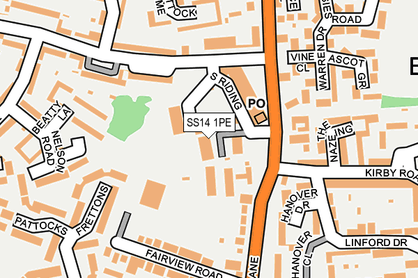
SS14 1PE lies on Gibcracks in Basildon. SS14 1PE is located in the St Martin's electoral ward, within the local authority district of Basildon and the English Parliamentary constituency of Basildon and Billericay. The Sub Integrated Care Board (ICB) Location is NHS Mid and South Essex ICB - 99E and the police force is Essex. This postcode has been in use since January 1980.


GetTheData
Source: OS OpenMap – Local (Ordnance Survey)
Source: OS VectorMap District (Ordnance Survey)
Licence: Open Government Licence (requires attribution)
| Easting | 572262 |
| Northing | 188643 |
| Latitude | 51.570344 |
| Longitude | 0.484271 |
GetTheData
Source: Open Postcode Geo
Licence: Open Government Licence
| Street | Gibcracks |
| Town/City | Basildon |
| Country | England |
| Postcode District | SS14 |
➜ See where SS14 is on a map ➜ Where is Basildon? | |
GetTheData
Source: Land Registry Price Paid Data
Licence: Open Government Licence
Elevation or altitude of SS14 1PE as distance above sea level:
| Metres | Feet | |
|---|---|---|
| Elevation | 30m | 98ft |
Elevation is measured from the approximate centre of the postcode, to the nearest point on an OS contour line from OS Terrain 50, which has contour spacing of ten vertical metres.
➜ How high above sea level am I? Find the elevation of your current position using your device's GPS.
GetTheData
Source: Open Postcode Elevation
Licence: Open Government Licence
| Ward | St Martin's |
| Constituency | Basildon And Billericay |
GetTheData
Source: ONS Postcode Database
Licence: Open Government Licence
| Gibcracks (Timberlog Lane) | Basildon | 101m |
| Stacey's Corner (Long Riding) | Basildon | 110m |
| Stacey's Corner (Long Riding) | Basildon | 117m |
| Luncies Road (Timberlog Lane) | Basildon | 148m |
| Luncies Road (Timberlog Lane) | Basildon | 153m |
| Pitsea Station | 1.9km |
| Basildon Station | 1.9km |
| Laindon Station | 4.2km |
GetTheData
Source: NaPTAN
Licence: Open Government Licence
| Median download speed | 13.4Mbps |
| Average download speed | 20.0Mbps |
| Maximum download speed | 40.00Mbps |
| Median upload speed | 2.8Mbps |
| Average upload speed | 3.7Mbps |
| Maximum upload speed | 7.39Mbps |
GetTheData
Source: Ofcom
Licence: Ofcom Terms of Use (requires attribution)
GetTheData
Source: ONS Postcode Database
Licence: Open Government Licence


➜ Get more ratings from the Food Standards Agency
GetTheData
Source: Food Standards Agency
Licence: FSA terms & conditions
| Last Collection | |||
|---|---|---|---|
| Location | Mon-Fri | Sat | Distance |
| Harvey Road | 18:30 | 11:30 | 714m |
| Vange Hill Drive | 17:45 | 12:00 | 749m |
| Chichester Close | 17:30 | 12:15 | 980m |
GetTheData
Source: Dracos
Licence: Creative Commons Attribution-ShareAlike
The below table lists the International Territorial Level (ITL) codes (formerly Nomenclature of Territorial Units for Statistics (NUTS) codes) and Local Administrative Units (LAU) codes for SS14 1PE:
| ITL 1 Code | Name |
|---|---|
| TLH | East |
| ITL 2 Code | Name |
| TLH3 | Essex |
| ITL 3 Code | Name |
| TLH37 | Essex Thames Gateway |
| LAU 1 Code | Name |
| E07000066 | Basildon |
GetTheData
Source: ONS Postcode Directory
Licence: Open Government Licence
The below table lists the Census Output Area (OA), Lower Layer Super Output Area (LSOA), and Middle Layer Super Output Area (MSOA) for SS14 1PE:
| Code | Name | |
|---|---|---|
| OA | E00108304 | |
| LSOA | E01021322 | Basildon 019A |
| MSOA | E02004442 | Basildon 019 |
GetTheData
Source: ONS Postcode Directory
Licence: Open Government Licence
| SS14 1NZ | Timberlog Lane | 73m |
| SS14 1PB | Timberlog Lane | 77m |
| SS14 1PJ | Timberlog Lane | 125m |
| SS14 1QY | Long Riding | 153m |
| SS14 1NY | Timberlog Lane | 153m |
| SS14 1GF | Vine Close | 161m |
| SS14 1PW | Fairview Road | 169m |
| SS14 1QU | Long Riding | 186m |
| SS14 1QH | Beatty Lane | 188m |
| SS14 1GE | Warren Drive | 196m |
GetTheData
Source: Open Postcode Geo; Land Registry Price Paid Data
Licence: Open Government Licence