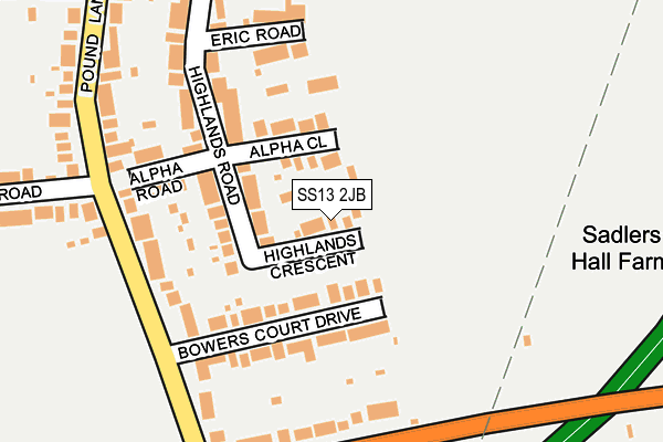
SS13 2JB lies on Highlands Crescent in Bowers Gifford, Basildon. SS13 2JB is located in the Pitsea South East electoral ward, within the local authority district of Basildon and the English Parliamentary constituency of South Basildon and East Thurrock. The Sub Integrated Care Board (ICB) Location is NHS Mid and South Essex ICB - 99E and the police force is Essex. This postcode has been in use since January 1980.


GetTheData
Source: OS OpenMap – Local (Ordnance Survey)
Source: OS VectorMap District (Ordnance Survey)
Licence: Open Government Licence (requires attribution)
| Easting | 575794 |
| Northing | 188577 |
| Latitude | 51.568659 |
| Longitude | 0.535121 |
GetTheData
Source: Open Postcode Geo
Licence: Open Government Licence
| Street | Highlands Crescent |
| Locality | Bowers Gifford |
| Town/City | Basildon |
| Country | England |
| Postcode District | SS13 |
➜ See where SS13 is on a map ➜ Where is North Benfleet? | |
GetTheData
Source: Land Registry Price Paid Data
Licence: Open Government Licence
Elevation or altitude of SS13 2JB as distance above sea level:
| Metres | Feet | |
|---|---|---|
| Elevation | 30m | 98ft |
Elevation is measured from the approximate centre of the postcode, to the nearest point on an OS contour line from OS Terrain 50, which has contour spacing of ten vertical metres.
➜ How high above sea level am I? Find the elevation of your current position using your device's GPS.
GetTheData
Source: Open Postcode Elevation
Licence: Open Government Licence
| Ward | Pitsea South East |
| Constituency | South Basildon And East Thurrock |
GetTheData
Source: ONS Postcode Database
Licence: Open Government Licence
THE SPORRAN, HIGHLANDS CRESCENT, BOWERS GIFFORD, BASILDON, SS13 2JB 2014 27 JUN £200,000 |
EAGLESTONE, HIGHLANDS CRESCENT, BOWERS GIFFORD, BASILDON, SS13 2JB 2006 17 MAR £175,000 |
BURLEIGH, HIGHLANDS CRESCENT, BOWERS GIFFORD, BASILDON, SS13 2JB 2006 3 JAN £200,000 |
GetTheData
Source: HM Land Registry Price Paid Data
Licence: Contains HM Land Registry data © Crown copyright and database right 2025. This data is licensed under the Open Government Licence v3.0.
| Bowers Court Drive (Pound Lane) | Bowers Gifford | 187m |
| Kelly Road (Pound Lane) | Bowers Gifford | 190m |
| Kelly Road (Pound Lane) | Bowers Gifford | 208m |
| Bowers Court Drive (Pound Lane) | Bowers Gifford | 212m |
| Pound Lane (London Road) | Bowers Gifford | 298m |
| Pitsea Station | 2.2km |
| Benfleet Station | 3.3km |
| Rayleigh Station | 5km |
GetTheData
Source: NaPTAN
Licence: Open Government Licence
| Percentage of properties with Next Generation Access | 100.0% |
| Percentage of properties with Superfast Broadband | 100.0% |
| Percentage of properties with Ultrafast Broadband | 0.0% |
| Percentage of properties with Full Fibre Broadband | 0.0% |
Superfast Broadband is between 30Mbps and 300Mbps
Ultrafast Broadband is > 300Mbps
| Percentage of properties unable to receive 2Mbps | 0.0% |
| Percentage of properties unable to receive 5Mbps | 0.0% |
| Percentage of properties unable to receive 10Mbps | 0.0% |
| Percentage of properties unable to receive 30Mbps | 0.0% |
GetTheData
Source: Ofcom
Licence: Ofcom Terms of Use (requires attribution)
GetTheData
Source: ONS Postcode Database
Licence: Open Government Licence


➜ Get more ratings from the Food Standards Agency
GetTheData
Source: Food Standards Agency
Licence: FSA terms & conditions
| Last Collection | |||
|---|---|---|---|
| Location | Mon-Fri | Sat | Distance |
| Great Tarpots Post Office | 17:30 | 12:15 | 1,201m |
| Rectory Road Post Office | 17:30 | 12:15 | 1,808m |
| Southwold Crescent | 17:00 | 12:00 | 1,991m |
GetTheData
Source: Dracos
Licence: Creative Commons Attribution-ShareAlike
The below table lists the International Territorial Level (ITL) codes (formerly Nomenclature of Territorial Units for Statistics (NUTS) codes) and Local Administrative Units (LAU) codes for SS13 2JB:
| ITL 1 Code | Name |
|---|---|
| TLH | East |
| ITL 2 Code | Name |
| TLH3 | Essex |
| ITL 3 Code | Name |
| TLH37 | Essex Thames Gateway |
| LAU 1 Code | Name |
| E07000066 | Basildon |
GetTheData
Source: ONS Postcode Directory
Licence: Open Government Licence
The below table lists the Census Output Area (OA), Lower Layer Super Output Area (LSOA), and Middle Layer Super Output Area (MSOA) for SS13 2JB:
| Code | Name | |
|---|---|---|
| OA | E00108247 | |
| LSOA | E01021312 | Basildon 011F |
| MSOA | E02004434 | Basildon 011 |
GetTheData
Source: ONS Postcode Directory
Licence: Open Government Licence
| SS13 2HZ | Alpha Close | 89m |
| SS13 2HH | Bowers Court Drive | 92m |
| SS13 2JA | Highlands Road | 102m |
| SS13 2HF | Pound Lane | 161m |
| SS13 2JD | Alpha Road | 162m |
| SS13 2HX | Highlands Road | 184m |
| SS13 2HE | London Road | 186m |
| SS13 2HY | Eric Road | 192m |
| SS13 2HJ | Pound Lane | 213m |
| SS13 2HU | Una Road | 256m |
GetTheData
Source: Open Postcode Geo; Land Registry Price Paid Data
Licence: Open Government Licence