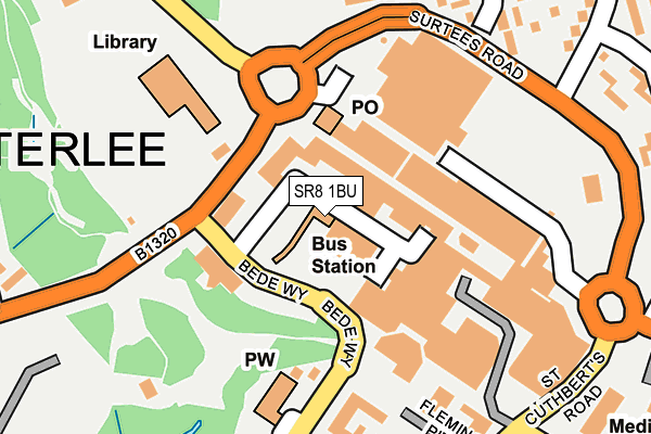
SR8 1BU is located in the Peterlee East electoral ward, within the unitary authority of County Durham and the English Parliamentary constituency of Easington. The Sub Integrated Care Board (ICB) Location is NHS North East and North Cumbria ICB - 84H and the police force is Durham. This postcode has been in use since January 1980.


GetTheData
Source: OS OpenMap – Local (Ordnance Survey)
Source: OS VectorMap District (Ordnance Survey)
Licence: Open Government Licence (requires attribution)
| Easting | 442850 |
| Northing | 540727 |
| Latitude | 54.759672 |
| Longitude | -1.335665 |
GetTheData
Source: Open Postcode Geo
Licence: Open Government Licence
| Country | England |
| Postcode District | SR8 |
➜ See where SR8 is on a map ➜ Where is Peterlee? | |
GetTheData
Source: Land Registry Price Paid Data
Licence: Open Government Licence
Elevation or altitude of SR8 1BU as distance above sea level:
| Metres | Feet | |
|---|---|---|
| Elevation | 100m | 328ft |
Elevation is measured from the approximate centre of the postcode, to the nearest point on an OS contour line from OS Terrain 50, which has contour spacing of ten vertical metres.
➜ How high above sea level am I? Find the elevation of your current position using your device's GPS.
GetTheData
Source: Open Postcode Elevation
Licence: Open Government Licence
| Ward | Peterlee East |
| Constituency | Easington |
GetTheData
Source: ONS Postcode Database
Licence: Open Government Licence
| Surtees Rd-edenhill Rd (Surtees Road) | Peterlee | 228m |
| St Cuthberts Road | Peterlee | 256m |
| St Cuthberts Road | Peterlee | 273m |
| Surtees Rd-edenhill Rd (Surtees Road) | Peterlee | 276m |
| Surtees Rd-edenhill Rd (Edenhill Road) | Peterlee | 301m |
GetTheData
Source: NaPTAN
Licence: Open Government Licence
GetTheData
Source: ONS Postcode Database
Licence: Open Government Licence


➜ Get more ratings from the Food Standards Agency
GetTheData
Source: Food Standards Agency
Licence: FSA terms & conditions
| Last Collection | |||
|---|---|---|---|
| Location | Mon-Fri | Sat | Distance |
| Eden Hill Road | 16:45 | 12:00 | 173m |
| O'neill Drive | 17:15 | 13:15 | 578m |
| Peterlee Post Office | 18:30 | 12:15 | 869m |
GetTheData
Source: Dracos
Licence: Creative Commons Attribution-ShareAlike
The below table lists the International Territorial Level (ITL) codes (formerly Nomenclature of Territorial Units for Statistics (NUTS) codes) and Local Administrative Units (LAU) codes for SR8 1BU:
| ITL 1 Code | Name |
|---|---|
| TLC | North East (England) |
| ITL 2 Code | Name |
| TLC1 | Tees Valley and Durham |
| ITL 3 Code | Name |
| TLC14 | Durham |
| LAU 1 Code | Name |
| E06000047 | County Durham |
GetTheData
Source: ONS Postcode Directory
Licence: Open Government Licence
The below table lists the Census Output Area (OA), Lower Layer Super Output Area (LSOA), and Middle Layer Super Output Area (MSOA) for SR8 1BU:
| Code | Name | |
|---|---|---|
| OA | E00105273 | |
| LSOA | E01020746 | County Durham 037A |
| MSOA | E02004329 | County Durham 037 |
GetTheData
Source: ONS Postcode Directory
Licence: Open Government Licence
| SR8 1BT | Burnhope Way | 57m |
| SR8 1BP | Yoden Way | 64m |
| SR8 1AS | Yoden Way | 143m |
| SR8 1AD | Bede Way | 153m |
| SR8 1AX | Upper Yoden Way | 163m |
| SR8 1PB | St Cuthberts Road | 258m |
| SR8 5HD | Hale Rise | 259m |
| SR8 5HE | Brandlings Way | 275m |
| SR8 5HU | Little Eden | 295m |
| SR8 5HA | Surtees Road | 301m |
GetTheData
Source: Open Postcode Geo; Land Registry Price Paid Data
Licence: Open Government Licence