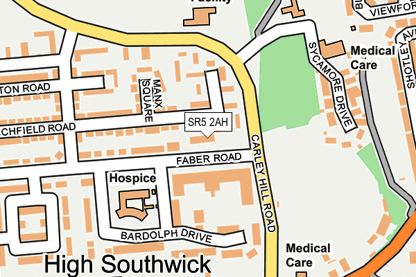
SR5 2AH is located in the Southwick electoral ward, within the metropolitan district of Sunderland and the English Parliamentary constituency of Sunderland Central. The Sub Integrated Care Board (ICB) Location is NHS North East and North Cumbria ICB - 00P and the police force is Northumbria. This postcode has been in use since July 2006.


GetTheData
Source: OS OpenMap – Local (Ordnance Survey)
Source: OS VectorMap District (Ordnance Survey)
Licence: Open Government Licence (requires attribution)
| Easting | 438706 |
| Northing | 559129 |
| Latitude | 54.925356 |
| Longitude | -1.397586 |
GetTheData
Source: Open Postcode Geo
Licence: Open Government Licence
| Country | England |
| Postcode District | SR5 |
➜ See where SR5 is on a map ➜ Where is Sunderland? | |
GetTheData
Source: Land Registry Price Paid Data
Licence: Open Government Licence
Elevation or altitude of SR5 2AH as distance above sea level:
| Metres | Feet | |
|---|---|---|
| Elevation | 50m | 164ft |
Elevation is measured from the approximate centre of the postcode, to the nearest point on an OS contour line from OS Terrain 50, which has contour spacing of ten vertical metres.
➜ How high above sea level am I? Find the elevation of your current position using your device's GPS.
GetTheData
Source: Open Postcode Elevation
Licence: Open Government Licence
| Ward | Southwick |
| Constituency | Sunderland Central |
GetTheData
Source: ONS Postcode Database
Licence: Open Government Licence
| Emsworth Road-school (Emsworth Road) | Carley Hill | 169m |
| Emsworth Road-school (Emsworth Road) | Carley Hill | 172m |
| Carley Hill Road | Carley Hill | 210m |
| Shakespeare Street-ellis Road (Shakespeare Street) | Carley Hill | 211m |
| Carley Hill Road | Carley Hill | 227m |
| Seaburn (Tyne And Wear Metro Station) (Station Road) | Fulwell | 842m |
| Stadium Of Light (Tyne And Wear Metro Station) (Millennium Way) | Sunderland Stadium Of Light | 1,231m |
| Pallion (Tyne And Wear Metro Station) (European Way) | Pallion | 1,873m |
| Seaburn Station | 0.8km |
| St Peters Station | 1.8km |
| Sunderland Station | 2.4km |
GetTheData
Source: NaPTAN
Licence: Open Government Licence
| Percentage of properties with Next Generation Access | 100.0% |
| Percentage of properties with Superfast Broadband | 100.0% |
| Percentage of properties with Ultrafast Broadband | 0.0% |
| Percentage of properties with Full Fibre Broadband | 0.0% |
Superfast Broadband is between 30Mbps and 300Mbps
Ultrafast Broadband is > 300Mbps
| Percentage of properties unable to receive 2Mbps | 0.0% |
| Percentage of properties unable to receive 5Mbps | 0.0% |
| Percentage of properties unable to receive 10Mbps | 0.0% |
| Percentage of properties unable to receive 30Mbps | 0.0% |
GetTheData
Source: Ofcom
Licence: Ofcom Terms of Use (requires attribution)
GetTheData
Source: ONS Postcode Database
Licence: Open Government Licence

➜ Get more ratings from the Food Standards Agency
GetTheData
Source: Food Standards Agency
Licence: FSA terms & conditions
| Last Collection | |||
|---|---|---|---|
| Location | Mon-Fri | Sat | Distance |
| Sidecliffe Road | 17:15 | 11:45 | 510m |
| Newcastle Road Post Office | 17:00 | 11:30 | 571m |
| Carley Road | 17:00 | 11:30 | 658m |
GetTheData
Source: Dracos
Licence: Creative Commons Attribution-ShareAlike
The below table lists the International Territorial Level (ITL) codes (formerly Nomenclature of Territorial Units for Statistics (NUTS) codes) and Local Administrative Units (LAU) codes for SR5 2AH:
| ITL 1 Code | Name |
|---|---|
| TLC | North East (England) |
| ITL 2 Code | Name |
| TLC2 | Northumberland, and Tyne and Wear |
| ITL 3 Code | Name |
| TLC23 | Sunderland |
| LAU 1 Code | Name |
| E08000024 | Sunderland |
GetTheData
Source: ONS Postcode Directory
Licence: Open Government Licence
The below table lists the Census Output Area (OA), Lower Layer Super Output Area (LSOA), and Middle Layer Super Output Area (MSOA) for SR5 2AH:
| Code | Name | |
|---|---|---|
| OA | E00044216 | |
| LSOA | E01008712 | Sunderland 004A |
| MSOA | E02001794 | Sunderland 004 |
GetTheData
Source: ONS Postcode Directory
Licence: Open Government Licence
| SR5 2NP | Clarendon Square | 77m |
| SR5 2NR | Manx Square | 106m |
| SR5 2NN | 110m | |
| SR5 2NW | Lichfield Road | 117m |
| SR5 2DE | Bardolph Drive | 132m |
| SR5 2QA | Erin Square | 155m |
| SR5 2PD | Norton Road | 189m |
| SR5 2PE | Shakespeare Street | 213m |
| SR5 1PP | Sycamore Drive | 215m |
| SR5 2PL | Shakespeare Street | 218m |
GetTheData
Source: Open Postcode Geo; Land Registry Price Paid Data
Licence: Open Government Licence