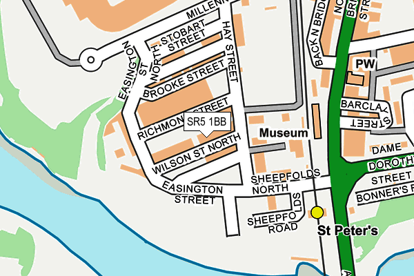
SR5 1BB lies on Wilson Street North in Sunderland. SR5 1BB is located in the Southwick electoral ward, within the metropolitan district of Sunderland and the English Parliamentary constituency of Sunderland Central. The Sub Integrated Care Board (ICB) Location is NHS North East and North Cumbria ICB - 00P and the police force is Northumbria. This postcode has been in use since June 1996.


GetTheData
Source: OS OpenMap – Local (Ordnance Survey)
Source: OS VectorMap District (Ordnance Survey)
Licence: Open Government Licence (requires attribution)
| Easting | 439450 |
| Northing | 557652 |
| Latitude | 54.912026 |
| Longitude | -1.386179 |
GetTheData
Source: Open Postcode Geo
Licence: Open Government Licence
| Street | Wilson Street North |
| Town/City | Sunderland |
| Country | England |
| Postcode District | SR5 |
➜ See where SR5 is on a map ➜ Where is Sunderland? | |
GetTheData
Source: Land Registry Price Paid Data
Licence: Open Government Licence
Elevation or altitude of SR5 1BB as distance above sea level:
| Metres | Feet | |
|---|---|---|
| Elevation | 20m | 66ft |
Elevation is measured from the approximate centre of the postcode, to the nearest point on an OS contour line from OS Terrain 50, which has contour spacing of ten vertical metres.
➜ How high above sea level am I? Find the elevation of your current position using your device's GPS.
GetTheData
Source: Open Postcode Elevation
Licence: Open Government Licence
| Ward | Southwick |
| Constituency | Sunderland Central |
GetTheData
Source: ONS Postcode Database
Licence: Open Government Licence
| Hays Street | Monkwearmouth | 92m |
| St Peters Metro (Sheepfolds North) | St Peter's | 141m |
| North Bridge Street | St Peter's | 198m |
| Wheatsheaf (North Bridge Street) | Monkwearmouth | 274m |
| Dame Dorothy Street | St Peter's | 290m |
| St Peter's (Tyne And Wear Metro Station) (Sheepfolds North) | St Peter's | 167m |
| Sunderland (Tyne And Wear Metro Station) (Station Street) | Sunderland | 653m |
| Stadium Of Light (Tyne And Wear Metro Station) (Millennium Way) | Sunderland Stadium Of Light | 721m |
| Park Lane (Tyne And Wear Metro Station) (Park Lane) | Park Lane | 1,090m |
| University (Tyne And Wear Metro Station) (A183 Chester Road) | University Of Sunderland | 1,093m |
| St Peters Station | 0.2km |
| Sunderland Station | 0.8km |
| Seaburn Station | 1.9km |
GetTheData
Source: NaPTAN
Licence: Open Government Licence
GetTheData
Source: ONS Postcode Database
Licence: Open Government Licence


➜ Get more ratings from the Food Standards Agency
GetTheData
Source: Food Standards Agency
Licence: FSA terms & conditions
| Last Collection | |||
|---|---|---|---|
| Location | Mon-Fri | Sat | Distance |
| Sheepfolds | 17:00 | 11:30 | 76m |
| North Bridge Street | 16:45 | 11:30 | 347m |
| High Street West | 18:30 | 12:30 | 534m |
GetTheData
Source: Dracos
Licence: Creative Commons Attribution-ShareAlike
The below table lists the International Territorial Level (ITL) codes (formerly Nomenclature of Territorial Units for Statistics (NUTS) codes) and Local Administrative Units (LAU) codes for SR5 1BB:
| ITL 1 Code | Name |
|---|---|
| TLC | North East (England) |
| ITL 2 Code | Name |
| TLC2 | Northumberland, and Tyne and Wear |
| ITL 3 Code | Name |
| TLC23 | Sunderland |
| LAU 1 Code | Name |
| E08000024 | Sunderland |
GetTheData
Source: ONS Postcode Directory
Licence: Open Government Licence
The below table lists the Census Output Area (OA), Lower Layer Super Output Area (LSOA), and Middle Layer Super Output Area (MSOA) for SR5 1BB:
| Code | Name | |
|---|---|---|
| OA | E00170218 | |
| LSOA | E01008791 | Sunderland 006F |
| MSOA | E02001796 | Sunderland 006 |
GetTheData
Source: ONS Postcode Directory
Licence: Open Government Licence
| SR5 1AB | North Bridge Street | 204m |
| SR5 1BT | Millennium Way | 205m |
| SR6 0AW | Barclay Street | 235m |
| SR6 0AY | Dundas Street | 267m |
| SR6 0AA | Bonnersfield | 273m |
| SR5 1AH | North Bridge Street | 274m |
| SR5 1AD | North Bridge Street | 300m |
| SR6 0AQ | Howick Park | 338m |
| SR6 0AD | 355m | |
| SR6 0DE | Howick Park | 391m |
GetTheData
Source: Open Postcode Geo; Land Registry Price Paid Data
Licence: Open Government Licence