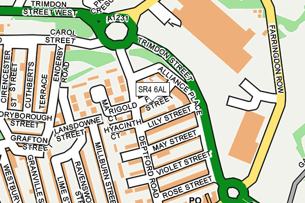
SR4 6AL lies on Fern Street in Sunderland. SR4 6AL is located in the Millfield electoral ward, within the metropolitan district of Sunderland and the English Parliamentary constituency of Sunderland Central. The Sub Integrated Care Board (ICB) Location is NHS North East and North Cumbria ICB - 00P and the police force is Northumbria. This postcode has been in use since January 1980.


GetTheData
Source: OS OpenMap – Local (Ordnance Survey)
Source: OS VectorMap District (Ordnance Survey)
Licence: Open Government Licence (requires attribution)
| Easting | 438799 |
| Northing | 557331 |
| Latitude | 54.909192 |
| Longitude | -1.396376 |
GetTheData
Source: Open Postcode Geo
Licence: Open Government Licence
| Street | Fern Street |
| Town/City | Sunderland |
| Country | England |
| Postcode District | SR4 |
➜ See where SR4 is on a map ➜ Where is Sunderland? | |
GetTheData
Source: Land Registry Price Paid Data
Licence: Open Government Licence
Elevation or altitude of SR4 6AL as distance above sea level:
| Metres | Feet | |
|---|---|---|
| Elevation | 40m | 131ft |
Elevation is measured from the approximate centre of the postcode, to the nearest point on an OS contour line from OS Terrain 50, which has contour spacing of ten vertical metres.
➜ How high above sea level am I? Find the elevation of your current position using your device's GPS.
GetTheData
Source: Open Postcode Elevation
Licence: Open Government Licence
| Ward | Millfield |
| Constituency | Sunderland Central |
GetTheData
Source: ONS Postcode Database
Licence: Open Government Licence
| Trimdon Street-b&q (Trimdon Street) | Millfield | 83m |
| Trimdon Street-b&q (Trimdon Street) | Millfield | 92m |
| Trimdon Street-retail Park (Trimdon Street) | Millfield | 158m |
| Trimdon Street-retail Park (Trimdon Street) | Millfield | 189m |
| Trimdon Street-enderby Road (Priestly Crescent) | Millfield | 224m |
| Millfield (Tyne And Wear Metro Station) (Hylton Road) | Millfield | 429m |
| University (Tyne And Wear Metro Station) (A183 Chester Road) | University Of Sunderland | 755m |
| St Peter's (Tyne And Wear Metro Station) (Sheepfolds North) | St Peter's | 845m |
| Sunderland (Tyne And Wear Metro Station) (Station Street) | Sunderland | 932m |
| Park Lane (Tyne And Wear Metro Station) (Park Lane) | Park Lane | 1,090m |
| St Peters Station | 0.8km |
| Sunderland Station | 1km |
| Seaburn Station | 2.3km |
GetTheData
Source: NaPTAN
Licence: Open Government Licence
| Percentage of properties with Next Generation Access | 100.0% |
| Percentage of properties with Superfast Broadband | 100.0% |
| Percentage of properties with Ultrafast Broadband | 0.0% |
| Percentage of properties with Full Fibre Broadband | 0.0% |
Superfast Broadband is between 30Mbps and 300Mbps
Ultrafast Broadband is > 300Mbps
| Median download speed | 24.2Mbps |
| Average download speed | 31.2Mbps |
| Maximum download speed | 70.22Mbps |
| Median upload speed | 4.5Mbps |
| Average upload speed | 5.9Mbps |
| Maximum upload speed | 14.78Mbps |
| Percentage of properties unable to receive 2Mbps | 0.0% |
| Percentage of properties unable to receive 5Mbps | 0.0% |
| Percentage of properties unable to receive 10Mbps | 0.0% |
| Percentage of properties unable to receive 30Mbps | 0.0% |
GetTheData
Source: Ofcom
Licence: Ofcom Terms of Use (requires attribution)
Estimated total energy consumption in SR4 6AL by fuel type, 2015.
| Consumption (kWh) | 208,434 |
|---|---|
| Meter count | 19 |
| Mean (kWh/meter) | 10,970 |
| Median (kWh/meter) | 10,391 |
| Consumption (kWh) | 37,354 |
|---|---|
| Meter count | 19 |
| Mean (kWh/meter) | 1,966 |
| Median (kWh/meter) | 1,843 |
GetTheData
Source: Postcode level gas estimates: 2015 (experimental)
Source: Postcode level electricity estimates: 2015 (experimental)
Licence: Open Government Licence
GetTheData
Source: ONS Postcode Database
Licence: Open Government Licence


➜ Get more ratings from the Food Standards Agency
GetTheData
Source: Food Standards Agency
Licence: FSA terms & conditions
| Last Collection | |||
|---|---|---|---|
| Location | Mon-Fri | Sat | Distance |
| Whitehall Terrace | 17:30 | 12:30 | 294m |
| Wharncliffe Street | 18:30 | 12:45 | 646m |
| Sheepfolds | 17:00 | 11:30 | 754m |
GetTheData
Source: Dracos
Licence: Creative Commons Attribution-ShareAlike
The below table lists the International Territorial Level (ITL) codes (formerly Nomenclature of Territorial Units for Statistics (NUTS) codes) and Local Administrative Units (LAU) codes for SR4 6AL:
| ITL 1 Code | Name |
|---|---|
| TLC | North East (England) |
| ITL 2 Code | Name |
| TLC2 | Northumberland, and Tyne and Wear |
| ITL 3 Code | Name |
| TLC23 | Sunderland |
| LAU 1 Code | Name |
| E08000024 | Sunderland |
GetTheData
Source: ONS Postcode Directory
Licence: Open Government Licence
The below table lists the Census Output Area (OA), Lower Layer Super Output Area (LSOA), and Middle Layer Super Output Area (MSOA) for SR4 6AL:
| Code | Name | |
|---|---|---|
| OA | E00044183 | |
| LSOA | E01008700 | Sunderland 013A |
| MSOA | E02001803 | Sunderland 013 |
GetTheData
Source: ONS Postcode Directory
Licence: Open Government Licence
| SR4 6AZ | Alliance Place | 51m |
| SR4 6AQ | Lily Street | 51m |
| SR4 6AH | Trimdon Street | 63m |
| SR4 6DX | Hyacinth Court | 86m |
| SR4 6AF | May Street | 95m |
| SR4 6DS | Jasmine Court | 99m |
| SR4 6DY | Marigold Court | 131m |
| SR4 6AE | Violet Street | 143m |
| SR4 6AX | Milburn Street | 145m |
| SR4 6DT | Dahlia Court | 147m |
GetTheData
Source: Open Postcode Geo; Land Registry Price Paid Data
Licence: Open Government Licence