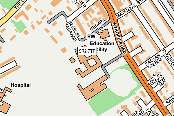
SR2 7TF is located in the St Michael's electoral ward, within the metropolitan district of Sunderland and the English Parliamentary constituency of Sunderland Central. The Sub Integrated Care Board (ICB) Location is NHS North East and North Cumbria ICB - 00P and the police force is Northumbria. This postcode has been in use since January 1980.


GetTheData
Source: OS OpenMap – Local (Ordnance Survey)
Source: OS VectorMap District (Ordnance Survey)
Licence: Open Government Licence (requires attribution)
| Easting | 440105 |
| Northing | 555210 |
| Latitude | 54.890038 |
| Longitude | -1.376316 |
GetTheData
Source: Open Postcode Geo
Licence: Open Government Licence
| Country | England |
| Postcode District | SR2 |
➜ See where SR2 is on a map ➜ Where is Sunderland? | |
GetTheData
Source: Land Registry Price Paid Data
Licence: Open Government Licence
Elevation or altitude of SR2 7TF as distance above sea level:
| Metres | Feet | |
|---|---|---|
| Elevation | 40m | 131ft |
Elevation is measured from the approximate centre of the postcode, to the nearest point on an OS contour line from OS Terrain 50, which has contour spacing of ten vertical metres.
➜ How high above sea level am I? Find the elevation of your current position using your device's GPS.
GetTheData
Source: Open Postcode Elevation
Licence: Open Government Licence
| Ward | St Michael's |
| Constituency | Sunderland Central |
GetTheData
Source: ONS Postcode Database
Licence: Open Government Licence
| South Moor School (Ryhope Road) | Grangetown | 99m |
| Ryhope Road-cedars Park (Ryhope Road) | Grangetown | 188m |
| Ryhope Road-bennett Court (Ryhope Road) | Grangetown | 220m |
| Ryhope Road-ryton Square (Ryhope Road) | Grangetown | 232m |
| Queen Alexandra Road-sea View Road (Queen Alexandra Road) | Hillview | 297m |
| Park Lane (Tyne And Wear Metro Station) (Park Lane) | Park Lane | 1,458m |
| University (Tyne And Wear Metro Station) (A183 Chester Road) | University Of Sunderland | 1,754m |
| Sunderland Station | 1.7km |
| St Peters Station | 2.4km |
| Seaburn Station | 4.4km |
GetTheData
Source: NaPTAN
Licence: Open Government Licence
GetTheData
Source: ONS Postcode Database
Licence: Open Government Licence


➜ Get more ratings from the Food Standards Agency
GetTheData
Source: Food Standards Agency
Licence: FSA terms & conditions
| Last Collection | |||
|---|---|---|---|
| Location | Mon-Fri | Sat | Distance |
| Leechmere Road | 18:30 | 11:45 | 401m |
| Greystoke Avenue | 17:00 | 11:30 | 419m |
| Tunstall Vale | 17:00 | 11:30 | 734m |
GetTheData
Source: Dracos
Licence: Creative Commons Attribution-ShareAlike
The below table lists the International Territorial Level (ITL) codes (formerly Nomenclature of Territorial Units for Statistics (NUTS) codes) and Local Administrative Units (LAU) codes for SR2 7TF:
| ITL 1 Code | Name |
|---|---|
| TLC | North East (England) |
| ITL 2 Code | Name |
| TLC2 | Northumberland, and Tyne and Wear |
| ITL 3 Code | Name |
| TLC23 | Sunderland |
| LAU 1 Code | Name |
| E08000024 | Sunderland |
GetTheData
Source: ONS Postcode Directory
Licence: Open Government Licence
The below table lists the Census Output Area (OA), Lower Layer Super Output Area (LSOA), and Middle Layer Super Output Area (MSOA) for SR2 7TF:
| Code | Name | |
|---|---|---|
| OA | E00044355 | |
| LSOA | E01008740 | Sunderland 022A |
| MSOA | E02001812 | Sunderland 022 |
GetTheData
Source: ONS Postcode Directory
Licence: Open Government Licence
| SR2 7TH | Belford Terrace East | 165m |
| SR2 7UX | Waldron Square | 186m |
| SR2 7TQ | Cedars Park | 187m |
| SR2 7UU | Wooler Square | 189m |
| SR2 7UT | Wadsley Square | 200m |
| SR2 7SZ | Ryhope Road | 201m |
| SR2 9QZ | Bennett Court | 209m |
| SR2 7UY | Wynyard Square | 216m |
| SR2 7TJ | Belford Road | 219m |
| SR2 7TA | Rushton Avenue | 220m |
GetTheData
Source: Open Postcode Geo; Land Registry Price Paid Data
Licence: Open Government Licence