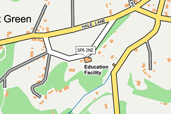
SP6 2NE lies on Hatchett Green in Hale, Fordingbridge. SP6 2NE is located in the Downlands & Forest North electoral ward, within the local authority district of New Forest and the English Parliamentary constituency of New Forest West. The Sub Integrated Care Board (ICB) Location is NHS Hampshire and Isle of Wight ICB - D9Y0V and the police force is Hampshire. This postcode has been in use since January 1980.


GetTheData
Source: OS OpenMap – Local (Ordnance Survey)
Source: OS VectorMap District (Ordnance Survey)
Licence: Open Government Licence (requires attribution)
| Easting | 419369 |
| Northing | 119066 |
| Latitude | 50.970688 |
| Longitude | -1.725524 |
GetTheData
Source: Open Postcode Geo
Licence: Open Government Licence
| Street | Hatchett Green |
| Locality | Hale |
| Town/City | Fordingbridge |
| Country | England |
| Postcode District | SP6 |
➜ See where SP6 is on a map ➜ Where is Hale? | |
GetTheData
Source: Land Registry Price Paid Data
Licence: Open Government Licence
Elevation or altitude of SP6 2NE as distance above sea level:
| Metres | Feet | |
|---|---|---|
| Elevation | 100m | 328ft |
Elevation is measured from the approximate centre of the postcode, to the nearest point on an OS contour line from OS Terrain 50, which has contour spacing of ten vertical metres.
➜ How high above sea level am I? Find the elevation of your current position using your device's GPS.
GetTheData
Source: Open Postcode Elevation
Licence: Open Government Licence
| Ward | Downlands & Forest North |
| Constituency | New Forest West |
GetTheData
Source: ONS Postcode Database
Licence: Open Government Licence
| Hale Village Green (Road Around The Green) | Hatchet Green | 158m |
| Woodfalls Cross (Hale Lane) | North Charford | 713m |
| Woodfalls Cross (Hale Lane B3080) | North Charford | 717m |
| Pineview Close (The Ridge) | Woodfalls | 987m |
| Pineview Close (The Ridge) | Woodfalls | 990m |
GetTheData
Source: NaPTAN
Licence: Open Government Licence
| Percentage of properties with Next Generation Access | 100.0% |
| Percentage of properties with Superfast Broadband | 85.7% |
| Percentage of properties with Ultrafast Broadband | 0.0% |
| Percentage of properties with Full Fibre Broadband | 0.0% |
Superfast Broadband is between 30Mbps and 300Mbps
Ultrafast Broadband is > 300Mbps
| Median download speed | 24.5Mbps |
| Average download speed | 23.2Mbps |
| Maximum download speed | 43.15Mbps |
| Median upload speed | 2.1Mbps |
| Average upload speed | 4.1Mbps |
| Maximum upload speed | 8.78Mbps |
| Percentage of properties unable to receive 2Mbps | 0.0% |
| Percentage of properties unable to receive 5Mbps | 0.0% |
| Percentage of properties unable to receive 10Mbps | 0.0% |
| Percentage of properties unable to receive 30Mbps | 14.3% |
GetTheData
Source: Ofcom
Licence: Ofcom Terms of Use (requires attribution)
GetTheData
Source: ONS Postcode Database
Licence: Open Government Licence


➜ Get more ratings from the Food Standards Agency
GetTheData
Source: Food Standards Agency
Licence: FSA terms & conditions
| Last Collection | |||
|---|---|---|---|
| Location | Mon-Fri | Sat | Distance |
| The Green | 16:00 | 09:00 | 178m |
| Forest Road | 16:00 | 10:30 | 1,070m |
| Queen Street | 16:00 | 08:15 | 1,073m |
GetTheData
Source: Dracos
Licence: Creative Commons Attribution-ShareAlike
The below table lists the International Territorial Level (ITL) codes (formerly Nomenclature of Territorial Units for Statistics (NUTS) codes) and Local Administrative Units (LAU) codes for SP6 2NE:
| ITL 1 Code | Name |
|---|---|
| TLJ | South East (England) |
| ITL 2 Code | Name |
| TLJ3 | Hampshire and Isle of Wight |
| ITL 3 Code | Name |
| TLJ36 | Central Hampshire |
| LAU 1 Code | Name |
| E07000091 | New Forest |
GetTheData
Source: ONS Postcode Directory
Licence: Open Government Licence
The below table lists the Census Output Area (OA), Lower Layer Super Output Area (LSOA), and Middle Layer Super Output Area (MSOA) for SP6 2NE:
| Code | Name | |
|---|---|---|
| OA | E00116925 | |
| LSOA | E01023012 | New Forest 001B |
| MSOA | E02004779 | New Forest 001 |
GetTheData
Source: ONS Postcode Directory
Licence: Open Government Licence
| SP6 2NB | Hatchett Green | 191m |
| SP6 2ND | Hatchett Green | 193m |
| SP6 2NG | Tethering Drove | 286m |
| SP6 2NF | Hatchet Close | 294m |
| SP6 2NL | 331m | |
| SP6 2NJ | St Georges Cottages | 365m |
| SP6 2NN | 379m | |
| SP6 2NU | Carters Close | 423m |
| SP6 2NH | Tethering Drove | 488m |
| SP6 2NW | Hale Road | 560m |
GetTheData
Source: Open Postcode Geo; Land Registry Price Paid Data
Licence: Open Government Licence