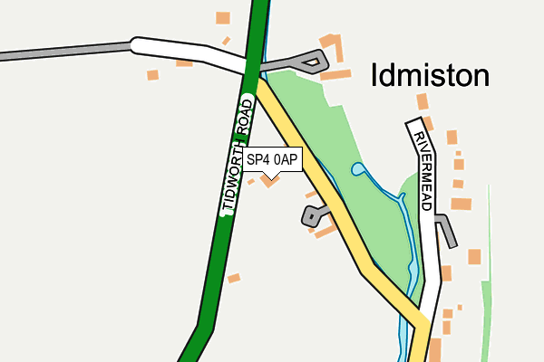
SP4 0AP is in Idmiston, Salisbury. SP4 0AP is located in the Winterslow & Upper Bourne Valley electoral ward, within the unitary authority of Wiltshire and the English Parliamentary constituency of Salisbury. The Sub Integrated Care Board (ICB) Location is NHS Bath and North East Somerset, Swindon and Wiltshire ICB - 92 and the police force is Wiltshire. This postcode has been in use since January 1980.


GetTheData
Source: OS OpenMap – Local (Ordnance Survey)
Source: OS VectorMap District (Ordnance Survey)
Licence: Open Government Licence (requires attribution)
| Easting | 419514 |
| Northing | 137785 |
| Latitude | 51.139000 |
| Longitude | -1.722444 |
GetTheData
Source: Open Postcode Geo
Licence: Open Government Licence
| Locality | Idmiston |
| Town/City | Salisbury |
| Country | England |
| Postcode District | SP4 |
➜ See where SP4 is on a map ➜ Where is Idmiston? | |
GetTheData
Source: Land Registry Price Paid Data
Licence: Open Government Licence
Elevation or altitude of SP4 0AP as distance above sea level:
| Metres | Feet | |
|---|---|---|
| Elevation | 70m | 230ft |
Elevation is measured from the approximate centre of the postcode, to the nearest point on an OS contour line from OS Terrain 50, which has contour spacing of ten vertical metres.
➜ How high above sea level am I? Find the elevation of your current position using your device's GPS.
GetTheData
Source: Open Postcode Elevation
Licence: Open Government Licence
| Ward | Winterslow & Upper Bourne Valley |
| Constituency | Salisbury |
GetTheData
Source: ONS Postcode Database
Licence: Open Government Licence
| The Turn (Idmiston Road) | Idmiston | 90m |
| The Turn (Idmiston Road) | Idmiston | 95m |
| The Turn (Tidworth Road) | Idmiston | 116m |
| Idmiston Bridge (Church Street) | Idmiston | 235m |
| Idmiston Bridge (Church Street) | Idmiston | 246m |
GetTheData
Source: NaPTAN
Licence: Open Government Licence
| Percentage of properties with Next Generation Access | 100.0% |
| Percentage of properties with Superfast Broadband | 100.0% |
| Percentage of properties with Ultrafast Broadband | 0.0% |
| Percentage of properties with Full Fibre Broadband | 0.0% |
Superfast Broadband is between 30Mbps and 300Mbps
Ultrafast Broadband is > 300Mbps
| Percentage of properties unable to receive 2Mbps | 0.0% |
| Percentage of properties unable to receive 5Mbps | 0.0% |
| Percentage of properties unable to receive 10Mbps | 0.0% |
| Percentage of properties unable to receive 30Mbps | 0.0% |
GetTheData
Source: Ofcom
Licence: Ofcom Terms of Use (requires attribution)
GetTheData
Source: ONS Postcode Database
Licence: Open Government Licence


➜ Get more ratings from the Food Standards Agency
GetTheData
Source: Food Standards Agency
Licence: FSA terms & conditions
| Last Collection | |||
|---|---|---|---|
| Location | Mon-Fri | Sat | Distance |
| Idminston | 16:00 | 09:30 | 120m |
| Idminston Village | 16:30 | 09:30 | 477m |
| Boscombe Village | 16:30 | 09:30 | 782m |
GetTheData
Source: Dracos
Licence: Creative Commons Attribution-ShareAlike
The below table lists the International Territorial Level (ITL) codes (formerly Nomenclature of Territorial Units for Statistics (NUTS) codes) and Local Administrative Units (LAU) codes for SP4 0AP:
| ITL 1 Code | Name |
|---|---|
| TLK | South West (England) |
| ITL 2 Code | Name |
| TLK1 | Gloucestershire, Wiltshire and Bath/Bristol area |
| ITL 3 Code | Name |
| TLK15 | Wiltshire |
| LAU 1 Code | Name |
| E06000054 | Wiltshire |
GetTheData
Source: ONS Postcode Directory
Licence: Open Government Licence
The below table lists the Census Output Area (OA), Lower Layer Super Output Area (LSOA), and Middle Layer Super Output Area (MSOA) for SP4 0AP:
| Code | Name | |
|---|---|---|
| OA | E00163385 | |
| LSOA | E01032032 | Wiltshire 049B |
| MSOA | E02006664 | Wiltshire 049 |
GetTheData
Source: ONS Postcode Directory
Licence: Open Government Licence
| SP4 0BE | Hale Barn Court | 73m |
| SP4 0AN | Tidworth Road | 116m |
| SP4 0AW | 163m | |
| SP4 0AR | Rivermead | 213m |
| SP4 0AT | Church Road | 343m |
| SP4 0AG | Tidworth Road | 488m |
| SP4 0AS | Rectory Court | 509m |
| SP4 0AY | Markan Road | 531m |
| SP4 0AE | Tidworth Road | 579m |
| SP4 0AH | Old Council Houses | 639m |
GetTheData
Source: Open Postcode Geo; Land Registry Price Paid Data
Licence: Open Government Licence