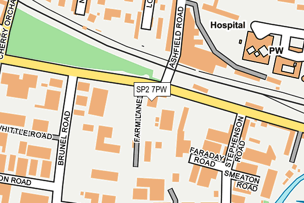
SP2 7PW is located in the Salisbury St Paul's electoral ward, within the unitary authority of Wiltshire and the English Parliamentary constituency of Salisbury. The Sub Integrated Care Board (ICB) Location is NHS Bath and North East Somerset, Swindon and Wiltshire ICB - 92 and the police force is Wiltshire. This postcode has been in use since January 1980.


GetTheData
Source: OS OpenMap – Local (Ordnance Survey)
Source: OS VectorMap District (Ordnance Survey)
Licence: Open Government Licence (requires attribution)
| Easting | 413143 |
| Northing | 130194 |
| Latitude | 51.070927 |
| Longitude | -1.813793 |
GetTheData
Source: Open Postcode Geo
Licence: Open Government Licence
| Country | England |
| Postcode District | SP2 |
➜ See where SP2 is on a map ➜ Where is Salisbury? | |
GetTheData
Source: Land Registry Price Paid Data
Licence: Open Government Licence
Elevation or altitude of SP2 7PW as distance above sea level:
| Metres | Feet | |
|---|---|---|
| Elevation | 50m | 164ft |
Elevation is measured from the approximate centre of the postcode, to the nearest point on an OS contour line from OS Terrain 50, which has contour spacing of ten vertical metres.
➜ How high above sea level am I? Find the elevation of your current position using your device's GPS.
GetTheData
Source: Open Postcode Elevation
Licence: Open Government Licence
| Ward | Salisbury St Paul's |
| Constituency | Salisbury |
GetTheData
Source: ONS Postcode Database
Licence: Open Government Licence
| Lower Road | Churchfields | 104m |
| Stephenson Road | Churchfields | 217m |
| Churchfields Road | Churchfields | 225m |
| Brunel Road (Mitchell Road) | Churchfields | 288m |
| Finchley Road (Wilton Road) | Salisbury | 307m |
| Salisbury Station | 0.5km |
GetTheData
Source: NaPTAN
Licence: Open Government Licence
GetTheData
Source: ONS Postcode Database
Licence: Open Government Licence


➜ Get more ratings from the Food Standards Agency
GetTheData
Source: Food Standards Agency
Licence: FSA terms & conditions
| Last Collection | |||
|---|---|---|---|
| Location | Mon-Fri | Sat | Distance |
| Steventon Road | 18:30 | 12:00 | 218m |
| Wilton Road | 17:00 | 12:00 | 292m |
| Brunel Road | 18:30 | 12:00 | 331m |
GetTheData
Source: Dracos
Licence: Creative Commons Attribution-ShareAlike
The below table lists the International Territorial Level (ITL) codes (formerly Nomenclature of Territorial Units for Statistics (NUTS) codes) and Local Administrative Units (LAU) codes for SP2 7PW:
| ITL 1 Code | Name |
|---|---|
| TLK | South West (England) |
| ITL 2 Code | Name |
| TLK1 | Gloucestershire, Wiltshire and Bath/Bristol area |
| ITL 3 Code | Name |
| TLK15 | Wiltshire |
| LAU 1 Code | Name |
| E06000054 | Wiltshire |
GetTheData
Source: ONS Postcode Directory
Licence: Open Government Licence
The below table lists the Census Output Area (OA), Lower Layer Super Output Area (LSOA), and Middle Layer Super Output Area (MSOA) for SP2 7PW:
| Code | Name | |
|---|---|---|
| OA | E00163206 | |
| LSOA | E01032003 | Wiltshire 055C |
| MSOA | E02006670 | Wiltshire 055 |
GetTheData
Source: ONS Postcode Directory
Licence: Open Government Licence
| SP2 7HL | Ashfield Road Trading Estate | 143m |
| SP2 7ET | Longland | 191m |
| SP2 7EW | Ashfield Road | 192m |
| SP2 7HT | Charnwood Road | 208m |
| SP2 7NU | Edison Road | 214m |
| SP2 7PY | Mitchell Road | 223m |
| SP2 7NW | Churchfields Road | 241m |
| SP2 7PU | Brunel Road | 254m |
| SP2 7HX | Nursery Road | 258m |
| SP2 7JA | Gorringe Road | 275m |
GetTheData
Source: Open Postcode Geo; Land Registry Price Paid Data
Licence: Open Government Licence