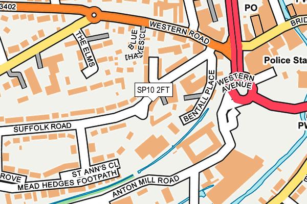
SP10 2FT is located in the Andover Winton electoral ward, within the local authority district of Test Valley and the English Parliamentary constituency of North West Hampshire. The Sub Integrated Care Board (ICB) Location is NHS Hampshire and Isle of Wight ICB - D9Y0V and the police force is Hampshire. This postcode has been in use since July 2014.


GetTheData
Source: OS OpenMap – Local (Ordnance Survey)
Source: OS VectorMap District (Ordnance Survey)
Licence: Open Government Licence (requires attribution)
| Easting | 436101 |
| Northing | 145207 |
| Latitude | 51.204939 |
| Longitude | -1.484633 |
GetTheData
Source: Open Postcode Geo
Licence: Open Government Licence
| Country | England |
| Postcode District | SP10 |
➜ See where SP10 is on a map ➜ Where is Andover? | |
GetTheData
Source: Land Registry Price Paid Data
Licence: Open Government Licence
Elevation or altitude of SP10 2FT as distance above sea level:
| Metres | Feet | |
|---|---|---|
| Elevation | 60m | 197ft |
Elevation is measured from the approximate centre of the postcode, to the nearest point on an OS contour line from OS Terrain 50, which has contour spacing of ten vertical metres.
➜ How high above sea level am I? Find the elevation of your current position using your device's GPS.
GetTheData
Source: Open Postcode Elevation
Licence: Open Government Licence
| Ward | Andover Winton |
| Constituency | North West Hampshire |
GetTheData
Source: ONS Postcode Database
Licence: Open Government Licence
| St Anns Close (Suffolk Road) | Andover | 15m |
| St Anns Close (Suffolk Road) | Andover | 50m |
| Junction Road (Western Road) | Andover | 147m |
| Junction Road (Western Road) | Andover | 156m |
| Asda Superstore | Andover | 222m |
| Andover Station | 0.9km |
GetTheData
Source: NaPTAN
Licence: Open Government Licence
| Percentage of properties with Next Generation Access | 100.0% |
| Percentage of properties with Superfast Broadband | 100.0% |
| Percentage of properties with Ultrafast Broadband | 0.0% |
| Percentage of properties with Full Fibre Broadband | 0.0% |
Superfast Broadband is between 30Mbps and 300Mbps
Ultrafast Broadband is > 300Mbps
| Median download speed | 39.1Mbps |
| Average download speed | 40.5Mbps |
| Maximum download speed | 78.12Mbps |
| Median upload speed | 9.8Mbps |
| Average upload speed | 8.3Mbps |
| Maximum upload speed | 19.53Mbps |
| Percentage of properties unable to receive 2Mbps | 0.0% |
| Percentage of properties unable to receive 5Mbps | 0.0% |
| Percentage of properties unable to receive 10Mbps | 0.0% |
| Percentage of properties unable to receive 30Mbps | 0.0% |
GetTheData
Source: Ofcom
Licence: Ofcom Terms of Use (requires attribution)
GetTheData
Source: ONS Postcode Database
Licence: Open Government Licence


➜ Get more ratings from the Food Standards Agency
GetTheData
Source: Food Standards Agency
Licence: FSA terms & conditions
| Last Collection | |||
|---|---|---|---|
| Location | Mon-Fri | Sat | Distance |
| Andover Post Office | 19:00 | 13:00 | 283m |
| South Street | 17:30 | 12:00 | 340m |
| Winchester Road | 17:30 | 12:00 | 466m |
GetTheData
Source: Dracos
Licence: Creative Commons Attribution-ShareAlike
The below table lists the International Territorial Level (ITL) codes (formerly Nomenclature of Territorial Units for Statistics (NUTS) codes) and Local Administrative Units (LAU) codes for SP10 2FT:
| ITL 1 Code | Name |
|---|---|
| TLJ | South East (England) |
| ITL 2 Code | Name |
| TLJ3 | Hampshire and Isle of Wight |
| ITL 3 Code | Name |
| TLJ36 | Central Hampshire |
| LAU 1 Code | Name |
| E07000093 | Test Valley |
GetTheData
Source: ONS Postcode Directory
Licence: Open Government Licence
The below table lists the Census Output Area (OA), Lower Layer Super Output Area (LSOA), and Middle Layer Super Output Area (MSOA) for SP10 2FT:
| Code | Name | |
|---|---|---|
| OA | E00117954 | |
| LSOA | E01023216 | Test Valley 006C |
| MSOA | E02004819 | Test Valley 006 |
GetTheData
Source: ONS Postcode Directory
Licence: Open Government Licence
| SP10 2JA | Bentall Place | 64m |
| SP10 2JY | Leicester Place | 72m |
| SP10 2JD | Suffolk Road | 77m |
| SP10 2JX | Suffolk Road | 92m |
| SP10 2RA | Blue Hayes Close | 92m |
| SP10 2GY | Suffolk Road | 115m |
| SP10 2JF | The Broadway | 134m |
| SP10 2JG | Western Road | 139m |
| SP10 2JH | The Elms | 159m |
| SP10 2LQ | Prince Albert Gardens | 177m |
GetTheData
Source: Open Postcode Geo; Land Registry Price Paid Data
Licence: Open Government Licence