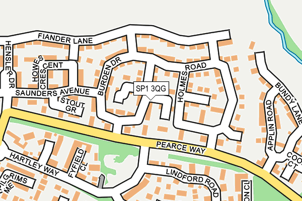
SP1 3QG lies on Burden Drive in Bishopdown, Salisbury. SP1 3QG is located in the Laverstock electoral ward, within the unitary authority of Wiltshire and the English Parliamentary constituency of Salisbury. The Sub Integrated Care Board (ICB) Location is NHS Bath and North East Somerset, Swindon and Wiltshire ICB - 92 and the police force is Wiltshire. This postcode has been in use since December 2015.


GetTheData
Source: OS OpenMap – Local (Ordnance Survey)
Source: OS VectorMap District (Ordnance Survey)
Licence: Open Government Licence (requires attribution)
| Easting | 415718 |
| Northing | 132520 |
| Latitude | 51.091773 |
| Longitude | -1.776930 |
GetTheData
Source: Open Postcode Geo
Licence: Open Government Licence
| Street | Burden Drive |
| Locality | Bishopdown |
| Town/City | Salisbury |
| Country | England |
| Postcode District | SP1 |
➜ See where SP1 is on a map ➜ Where is Salisbury? | |
GetTheData
Source: Land Registry Price Paid Data
Licence: Open Government Licence
Elevation or altitude of SP1 3QG as distance above sea level:
| Metres | Feet | |
|---|---|---|
| Elevation | 70m | 230ft |
Elevation is measured from the approximate centre of the postcode, to the nearest point on an OS contour line from OS Terrain 50, which has contour spacing of ten vertical metres.
➜ How high above sea level am I? Find the elevation of your current position using your device's GPS.
GetTheData
Source: Open Postcode Elevation
Licence: Open Government Licence
| Ward | Laverstock |
| Constituency | Salisbury |
GetTheData
Source: ONS Postcode Database
Licence: Open Government Licence
2023 12 MAY £385,000 |
2023 21 APR £615,000 |
2021 15 SEP £553,000 |
2021 16 AUG £541,000 |
2017 26 JUN £469,995 |
59, BURDEN DRIVE, BISHOPDOWN, SALISBURY, SP1 3QG 2017 27 JAN £314,995 |
49, BURDEN DRIVE, BISHOPDOWN, SALISBURY, SP1 3QG 2016 23 DEC £479,000 |
2016 18 NOV £349,000 |
51, BURDEN DRIVE, BISHOPDOWN, SALISBURY, SP1 3QG 2016 31 OCT £475,000 |
2016 28 OCT £479,000 |
GetTheData
Source: HM Land Registry Price Paid Data
Licence: Contains HM Land Registry data © Crown copyright and database right 2025. This data is licensed under the Open Government Licence v3.0.
| Pearce Way | Bishopdown Farm | 215m |
| Pearce Way | Bishopdown Farm | 219m |
| Saunders Avenue | Bishopdown | 284m |
| St Christophers Close (St Thomas Way) | Bishopdown Farm | 316m |
| The Crossroads (Greenacres) | Ford | 373m |
| Salisbury Station | 3.1km |
GetTheData
Source: NaPTAN
Licence: Open Government Licence
| Percentage of properties with Next Generation Access | 100.0% |
| Percentage of properties with Superfast Broadband | 100.0% |
| Percentage of properties with Ultrafast Broadband | 100.0% |
| Percentage of properties with Full Fibre Broadband | 97.4% |
Superfast Broadband is between 30Mbps and 300Mbps
Ultrafast Broadband is > 300Mbps
| Median download speed | 100.0Mbps |
| Average download speed | 128.7Mbps |
| Maximum download speed | 350.00Mbps |
Ofcom does not currently provide upload speed data for SP1 3QG. This is because there are less than four broadband connections in this postcode.
| Percentage of properties unable to receive 2Mbps | 0.0% |
| Percentage of properties unable to receive 5Mbps | 0.0% |
| Percentage of properties unable to receive 10Mbps | 0.0% |
| Percentage of properties unable to receive 30Mbps | 0.0% |
GetTheData
Source: Ofcom
Licence: Ofcom Terms of Use (requires attribution)
GetTheData
Source: ONS Postcode Database
Licence: Open Government Licence


➜ Get more ratings from the Food Standards Agency
GetTheData
Source: Food Standards Agency
Licence: FSA terms & conditions
| Last Collection | |||
|---|---|---|---|
| Location | Mon-Fri | Sat | Distance |
| St Thomas Way | 16:45 | 12:00 | 502m |
| Sycamore Drive | 16:45 | 12:00 | 523m |
| Ford | 16:00 | 10:00 | 660m |
GetTheData
Source: Dracos
Licence: Creative Commons Attribution-ShareAlike
The below table lists the International Territorial Level (ITL) codes (formerly Nomenclature of Territorial Units for Statistics (NUTS) codes) and Local Administrative Units (LAU) codes for SP1 3QG:
| ITL 1 Code | Name |
|---|---|
| TLK | South West (England) |
| ITL 2 Code | Name |
| TLK1 | Gloucestershire, Wiltshire and Bath/Bristol area |
| ITL 3 Code | Name |
| TLK15 | Wiltshire |
| LAU 1 Code | Name |
| E06000054 | Wiltshire |
GetTheData
Source: ONS Postcode Directory
Licence: Open Government Licence
The below table lists the Census Output Area (OA), Lower Layer Super Output Area (LSOA), and Middle Layer Super Output Area (MSOA) for SP1 3QG:
| Code | Name | |
|---|---|---|
| OA | E00163126 | |
| LSOA | E01031984 | Wiltshire 051A |
| MSOA | E02006666 | Wiltshire 051 |
GetTheData
Source: ONS Postcode Directory
Licence: Open Government Licence
| SP1 3ER | Holmes Road | 110m |
| SP1 3DF | Holmes Road | 175m |
| SP1 3FU | Howes Crescent | 182m |
| SP1 3WU | Fyfield Close | 194m |
| SP1 3ZA | Appleshaw Way | 196m |
| SP1 3WX | Lindford Road | 203m |
| SP1 3WS | Hartley Way | 205m |
| SP1 3BD | Fiander Lane | 227m |
| SP1 3WT | Saintes Close | 236m |
| SP1 3PD | Applin Road | 240m |
GetTheData
Source: Open Postcode Geo; Land Registry Price Paid Data
Licence: Open Government Licence