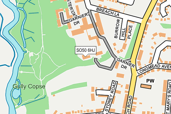
SO50 6HJ lies on Hargreaves Walk in Eastleigh. SO50 6HJ is located in the Bishopstoke electoral ward, within the local authority district of Eastleigh and the English Parliamentary constituency of Eastleigh. The Sub Integrated Care Board (ICB) Location is NHS Hampshire and Isle of Wight ICB - D9Y0V and the police force is Hampshire. This postcode has been in use since July 2015.


GetTheData
Source: OS OpenMap – Local (Ordnance Survey)
Source: OS VectorMap District (Ordnance Survey)
Licence: Open Government Licence (requires attribution)
| Easting | 446592 |
| Northing | 119951 |
| Latitude | 50.977085 |
| Longitude | -1.337714 |
GetTheData
Source: Open Postcode Geo
Licence: Open Government Licence
| Street | Hargreaves Walk |
| Town/City | Eastleigh |
| Country | England |
| Postcode District | SO50 |
➜ See where SO50 is on a map ➜ Where is Eastleigh? | |
GetTheData
Source: Land Registry Price Paid Data
Licence: Open Government Licence
Elevation or altitude of SO50 6HJ as distance above sea level:
| Metres | Feet | |
|---|---|---|
| Elevation | 40m | 131ft |
Elevation is measured from the approximate centre of the postcode, to the nearest point on an OS contour line from OS Terrain 50, which has contour spacing of ten vertical metres.
➜ How high above sea level am I? Find the elevation of your current position using your device's GPS.
GetTheData
Source: Open Postcode Elevation
Licence: Open Government Licence
| Ward | Bishopstoke |
| Constituency | Eastleigh |
GetTheData
Source: ONS Postcode Database
Licence: Open Government Licence
| St Mary's Church (Church Road) | Stoke Common | 183m |
| The Mount Hospital (Church Road) | Stoke Common | 233m |
| Church Road (Stoke Park Road) | Stoke Common | 270m |
| West Drive (Sedgewick Road) | Bishopstoke | 448m |
| Drake Road | Stoke Common | 466m |
| Eastleigh Station | 1.2km |
| Chandlers Ford Station | 3.4km |
| Southampton Airport Parkway Station | 3.4km |
GetTheData
Source: NaPTAN
Licence: Open Government Licence
| Percentage of properties with Next Generation Access | 100.0% |
| Percentage of properties with Superfast Broadband | 100.0% |
| Percentage of properties with Ultrafast Broadband | 0.0% |
| Percentage of properties with Full Fibre Broadband | 0.0% |
Superfast Broadband is between 30Mbps and 300Mbps
Ultrafast Broadband is > 300Mbps
| Percentage of properties unable to receive 2Mbps | 0.0% |
| Percentage of properties unable to receive 5Mbps | 0.0% |
| Percentage of properties unable to receive 10Mbps | 0.0% |
| Percentage of properties unable to receive 30Mbps | 0.0% |
GetTheData
Source: Ofcom
Licence: Ofcom Terms of Use (requires attribution)
GetTheData
Source: ONS Postcode Database
Licence: Open Government Licence


➜ Get more ratings from the Food Standards Agency
GetTheData
Source: Food Standards Agency
Licence: FSA terms & conditions
| Last Collection | |||
|---|---|---|---|
| Location | Mon-Fri | Sat | Distance |
| Sedgwick Road | 17:15 | 11:30 | 483m |
| Stoke Common Road | 17:15 | 11:45 | 608m |
| Bishopstoke Post Office | 17:15 | 11:45 | 722m |
GetTheData
Source: Dracos
Licence: Creative Commons Attribution-ShareAlike
The below table lists the International Territorial Level (ITL) codes (formerly Nomenclature of Territorial Units for Statistics (NUTS) codes) and Local Administrative Units (LAU) codes for SO50 6HJ:
| ITL 1 Code | Name |
|---|---|
| TLJ | South East (England) |
| ITL 2 Code | Name |
| TLJ3 | Hampshire and Isle of Wight |
| ITL 3 Code | Name |
| TLJ35 | South Hampshire |
| LAU 1 Code | Name |
| E07000086 | Eastleigh |
GetTheData
Source: ONS Postcode Directory
Licence: Open Government Licence
The below table lists the Census Output Area (OA), Lower Layer Super Output Area (LSOA), and Middle Layer Super Output Area (MSOA) for SO50 6HJ:
| Code | Name | |
|---|---|---|
| OA | E00115130 | |
| LSOA | E01022648 | Eastleigh 004A |
| MSOA | E02004715 | Eastleigh 004 |
GetTheData
Source: ONS Postcode Directory
Licence: Open Government Licence
| SO50 6HE | Garnier Drive | 104m |
| SO50 6LT | Burrow Hill Place | 104m |
| SO50 6HP | Twynam Way | 106m |
| SO50 6EJ | Longmead Avenue | 153m |
| SO50 6DJ | Sydney Road | 157m |
| SO50 6DQ | Church Road | 158m |
| SO50 6LU | Breach Lane | 164m |
| SO50 6DN | Church Road | 187m |
| SO50 6EY | Edward Avenue | 201m |
| SO50 6DH | St Margarets Road | 207m |
GetTheData
Source: Open Postcode Geo; Land Registry Price Paid Data
Licence: Open Government Licence