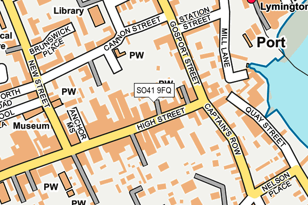
SO41 9FQ is located in the Lymington electoral ward, within the local authority district of New Forest and the English Parliamentary constituency of New Forest West. The Sub Integrated Care Board (ICB) Location is NHS Hampshire and Isle of Wight ICB - D9Y0V and the police force is Hampshire. This postcode has been in use since February 2009.


GetTheData
Source: OS OpenMap – Local (Ordnance Survey)
Source: OS VectorMap District (Ordnance Survey)
Licence: Open Government Licence (requires attribution)
| Easting | 432566 |
| Northing | 95606 |
| Latitude | 50.759140 |
| Longitude | -1.539660 |
GetTheData
Source: Open Postcode Geo
Licence: Open Government Licence
| Country | England |
| Postcode District | SO41 |
➜ See where SO41 is on a map ➜ Where is Lymington? | |
GetTheData
Source: Land Registry Price Paid Data
Licence: Open Government Licence
Elevation or altitude of SO41 9FQ as distance above sea level:
| Metres | Feet | |
|---|---|---|
| Elevation | 20m | 66ft |
Elevation is measured from the approximate centre of the postcode, to the nearest point on an OS contour line from OS Terrain 50, which has contour spacing of ten vertical metres.
➜ How high above sea level am I? Find the elevation of your current position using your device's GPS.
GetTheData
Source: Open Postcode Elevation
Licence: Open Government Licence
| Ward | Lymington |
| Constituency | New Forest West |
GetTheData
Source: ONS Postcode Database
Licence: Open Government Licence
| Station Street (Gosport Street) | Lymington | 105m |
| Station Street (Gosport Street) | Lymington | 110m |
| Town Railway Station (Forecourt) | Lymington | 244m |
| Bridge Road (Gosport Street) | Lymington | 283m |
| Bridge Road (Gosport Street) | Lymington | 287m |
| Lymington Town Station | 0.3km |
| Lymington Pier Station | 0.7km |
| Sway Station | 5.7km |
GetTheData
Source: NaPTAN
Licence: Open Government Licence
| Percentage of properties with Next Generation Access | 100.0% |
| Percentage of properties with Superfast Broadband | 100.0% |
| Percentage of properties with Ultrafast Broadband | 0.0% |
| Percentage of properties with Full Fibre Broadband | 0.0% |
Superfast Broadband is between 30Mbps and 300Mbps
Ultrafast Broadband is > 300Mbps
| Percentage of properties unable to receive 2Mbps | 0.0% |
| Percentage of properties unable to receive 5Mbps | 0.0% |
| Percentage of properties unable to receive 10Mbps | 0.0% |
| Percentage of properties unable to receive 30Mbps | 0.0% |
GetTheData
Source: Ofcom
Licence: Ofcom Terms of Use (requires attribution)
GetTheData
Source: ONS Postcode Database
Licence: Open Government Licence


➜ Get more ratings from the Food Standards Agency
GetTheData
Source: Food Standards Agency
Licence: FSA terms & conditions
| Last Collection | |||
|---|---|---|---|
| Location | Mon-Fri | Sat | Distance |
| High Street (East) | 17:15 | 11:45 | 67m |
| Town Quay | 17:00 | 11:30 | 241m |
| Railway Station | 17:00 | 11:30 | 254m |
GetTheData
Source: Dracos
Licence: Creative Commons Attribution-ShareAlike
The below table lists the International Territorial Level (ITL) codes (formerly Nomenclature of Territorial Units for Statistics (NUTS) codes) and Local Administrative Units (LAU) codes for SO41 9FQ:
| ITL 1 Code | Name |
|---|---|
| TLJ | South East (England) |
| ITL 2 Code | Name |
| TLJ3 | Hampshire and Isle of Wight |
| ITL 3 Code | Name |
| TLJ36 | Central Hampshire |
| LAU 1 Code | Name |
| E07000091 | New Forest |
GetTheData
Source: ONS Postcode Directory
Licence: Open Government Licence
The below table lists the Census Output Area (OA), Lower Layer Super Output Area (LSOA), and Middle Layer Super Output Area (MSOA) for SO41 9FQ:
| Code | Name | |
|---|---|---|
| OA | E00117096 | |
| LSOA | E01023042 | New Forest 017D |
| MSOA | E02004795 | New Forest 017 |
GetTheData
Source: ONS Postcode Directory
Licence: Open Government Licence
| SO41 9EP | Earley Court | 19m |
| SO41 9AQ | High Street | 28m |
| SO41 9FT | Victoria Mews | 45m |
| SO41 9AA | High Street | 75m |
| SO41 9EN | Haydens Court | 86m |
| SO41 9AD | High Street | 89m |
| SO41 9AP | High Street | 94m |
| SO41 9BG | Gosport Street | 103m |
| SO41 9AE | Navarino Court | 116m |
| SO41 3AR | Quay Hill | 138m |
GetTheData
Source: Open Postcode Geo; Land Registry Price Paid Data
Licence: Open Government Licence