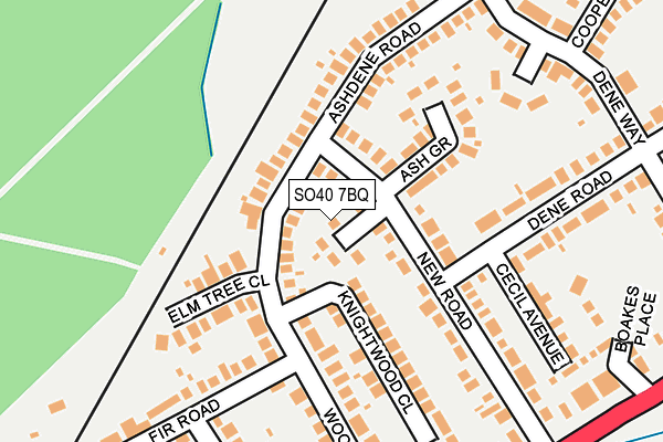
SO40 7BQ lies on Ashurst Close in Ashurst, Southampton. SO40 7BQ is located in the Ashurst, Bramshaw, Copythorne & Netley Marsh electoral ward, within the local authority district of New Forest and the English Parliamentary constituency of New Forest East. The Sub Integrated Care Board (ICB) Location is NHS Hampshire and Isle of Wight ICB - D9Y0V and the police force is Hampshire. This postcode has been in use since December 1994.


GetTheData
Source: OS OpenMap – Local (Ordnance Survey)
Source: OS VectorMap District (Ordnance Survey)
Licence: Open Government Licence (requires attribution)
| Easting | 433954 |
| Northing | 110961 |
| Latitude | 50.897136 |
| Longitude | -1.518566 |
GetTheData
Source: Open Postcode Geo
Licence: Open Government Licence
| Street | Ashurst Close |
| Locality | Ashurst |
| Town/City | Southampton |
| Country | England |
| Postcode District | SO40 |
➜ See where SO40 is on a map ➜ Where is Ashurst? | |
GetTheData
Source: Land Registry Price Paid Data
Licence: Open Government Licence
Elevation or altitude of SO40 7BQ as distance above sea level:
| Metres | Feet | |
|---|---|---|
| Elevation | 20m | 66ft |
Elevation is measured from the approximate centre of the postcode, to the nearest point on an OS contour line from OS Terrain 50, which has contour spacing of ten vertical metres.
➜ How high above sea level am I? Find the elevation of your current position using your device's GPS.
GetTheData
Source: Open Postcode Elevation
Licence: Open Government Licence
| Ward | Ashurst, Bramshaw, Copythorne & Netley Marsh |
| Constituency | New Forest East |
GetTheData
Source: ONS Postcode Database
Licence: Open Government Licence
2, ASHURST CLOSE, ASHURST, SOUTHAMPTON, SO40 7BQ 2017 17 MAR £325,000 |
2016 30 JUN £375,000 |
4, ASHURST CLOSE, ASHURST, SOUTHAMPTON, SO40 7BQ 2012 14 DEC £345,000 |
1996 6 MAR £94,500 |
GetTheData
Source: HM Land Registry Price Paid Data
Licence: Contains HM Land Registry data © Crown copyright and database right 2025. This data is licensed under the Open Government Licence v3.0.
| Ashdene Road (New Road) | Foxhills | 47m |
| Ashdene Road (New Road) | Foxhills | 54m |
| Deane Way (Ashdene Road) | Foxhills | 221m |
| Deane Way (Ashdene Road) | Foxhills | 225m |
| New Road | Foxhills | 234m |
| Ashurst New Forest Station | 1km |
| Totton Station | 3.4km |
| Redbridge (Hants) Station | 4.2km |
GetTheData
Source: NaPTAN
Licence: Open Government Licence
| Percentage of properties with Next Generation Access | 100.0% |
| Percentage of properties with Superfast Broadband | 100.0% |
| Percentage of properties with Ultrafast Broadband | 0.0% |
| Percentage of properties with Full Fibre Broadband | 0.0% |
Superfast Broadband is between 30Mbps and 300Mbps
Ultrafast Broadband is > 300Mbps
| Percentage of properties unable to receive 2Mbps | 0.0% |
| Percentage of properties unable to receive 5Mbps | 0.0% |
| Percentage of properties unable to receive 10Mbps | 0.0% |
| Percentage of properties unable to receive 30Mbps | 0.0% |
GetTheData
Source: Ofcom
Licence: Ofcom Terms of Use (requires attribution)
GetTheData
Source: ONS Postcode Database
Licence: Open Government Licence


➜ Get more ratings from the Food Standards Agency
GetTheData
Source: Food Standards Agency
Licence: FSA terms & conditions
| Last Collection | |||
|---|---|---|---|
| Location | Mon-Fri | Sat | Distance |
| Wood Road | 16:45 | 09:15 | 283m |
| Ashurst Post Office | 16:45 | 09:15 | 605m |
| Whartons Lane | 16:45 | 08:45 | 676m |
GetTheData
Source: Dracos
Licence: Creative Commons Attribution-ShareAlike
The below table lists the International Territorial Level (ITL) codes (formerly Nomenclature of Territorial Units for Statistics (NUTS) codes) and Local Administrative Units (LAU) codes for SO40 7BQ:
| ITL 1 Code | Name |
|---|---|
| TLJ | South East (England) |
| ITL 2 Code | Name |
| TLJ3 | Hampshire and Isle of Wight |
| ITL 3 Code | Name |
| TLJ36 | Central Hampshire |
| LAU 1 Code | Name |
| E07000091 | New Forest |
GetTheData
Source: ONS Postcode Directory
Licence: Open Government Licence
The below table lists the Census Output Area (OA), Lower Layer Super Output Area (LSOA), and Middle Layer Super Output Area (MSOA) for SO40 7BQ:
| Code | Name | |
|---|---|---|
| OA | E00116748 | |
| LSOA | E01022977 | New Forest 006A |
| MSOA | E02004784 | New Forest 006 |
GetTheData
Source: ONS Postcode Directory
Licence: Open Government Licence
| SO40 7BP | Ashurst Close | 41m |
| SO40 7BW | Ashdene Road | 90m |
| SO40 7BT | Ashdene Road | 123m |
| SO40 7BN | Ash Grove | 124m |
| SO40 7BR | New Road | 129m |
| SO40 7FE | Knightwood Close | 136m |
| SO40 7FD | Elmtree Close | 137m |
| SO40 7BS | New Road | 145m |
| SO40 7BY | Woodside Gardens | 197m |
| SO40 7BD | Wood Road | 199m |
GetTheData
Source: Open Postcode Geo; Land Registry Price Paid Data
Licence: Open Government Licence