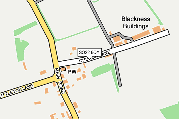
SO22 6QY lies on Church Lane in Littleton, Winchester. SO22 6QY is located in the Wonston and Micheldever electoral ward, within the local authority district of Winchester and the English Parliamentary constituency of Winchester. The Sub Integrated Care Board (ICB) Location is NHS Hampshire and Isle of Wight ICB - D9Y0V and the police force is Hampshire. This postcode has been in use since January 1980.


GetTheData
Source: OS OpenMap – Local (Ordnance Survey)
Source: OS VectorMap District (Ordnance Survey)
Licence: Open Government Licence (requires attribution)
| Easting | 445441 |
| Northing | 132932 |
| Latitude | 51.093904 |
| Longitude | -1.352495 |
GetTheData
Source: Open Postcode Geo
Licence: Open Government Licence
| Street | Church Lane |
| Locality | Littleton |
| Town/City | Winchester |
| Country | England |
| Postcode District | SO22 |
➜ See where SO22 is on a map ➜ Where is Littleton? | |
GetTheData
Source: Land Registry Price Paid Data
Licence: Open Government Licence
Elevation or altitude of SO22 6QY as distance above sea level:
| Metres | Feet | |
|---|---|---|
| Elevation | 70m | 230ft |
Elevation is measured from the approximate centre of the postcode, to the nearest point on an OS contour line from OS Terrain 50, which has contour spacing of ten vertical metres.
➜ How high above sea level am I? Find the elevation of your current position using your device's GPS.
GetTheData
Source: Open Postcode Elevation
Licence: Open Government Licence
| Ward | Wonston And Micheldever |
| Constituency | Winchester |
GetTheData
Source: ONS Postcode Database
Licence: Open Government Licence
2006 11 SEP £855,000 |
2001 12 JAN £590,000 |
1996 8 OCT £286,000 |
GetTheData
Source: HM Land Registry Price Paid Data
Licence: Contains HM Land Registry data © Crown copyright and database right 2025. This data is licensed under the Open Government Licence v3.0.
| Church Lane (Main Road) | Littleton | 110m |
| Church Lane (Main Road) | Littleton | 120m |
| The Running Horse (Main Road) | Littleton | 398m |
| The Running Horse (Main Road) | Littleton | 405m |
| Littleton Stud (Main Road) | Long Park | 420m |
| Winchester Station | 3.8km |
GetTheData
Source: NaPTAN
Licence: Open Government Licence
| Percentage of properties with Next Generation Access | 100.0% |
| Percentage of properties with Superfast Broadband | 100.0% |
| Percentage of properties with Ultrafast Broadband | 0.0% |
| Percentage of properties with Full Fibre Broadband | 0.0% |
Superfast Broadband is between 30Mbps and 300Mbps
Ultrafast Broadband is > 300Mbps
| Percentage of properties unable to receive 2Mbps | 0.0% |
| Percentage of properties unable to receive 5Mbps | 0.0% |
| Percentage of properties unable to receive 10Mbps | 0.0% |
| Percentage of properties unable to receive 30Mbps | 0.0% |
GetTheData
Source: Ofcom
Licence: Ofcom Terms of Use (requires attribution)
GetTheData
Source: ONS Postcode Database
Licence: Open Government Licence


➜ Get more ratings from the Food Standards Agency
GetTheData
Source: Food Standards Agency
Licence: FSA terms & conditions
| Last Collection | |||
|---|---|---|---|
| Location | Mon-Fri | Sat | Distance |
| Littleton Manor | 16:15 | 08:30 | 122m |
| Littleton Post Office | 16:15 | 08:45 | 901m |
| Fromonde Road | 16:15 | 11:00 | 1,661m |
GetTheData
Source: Dracos
Licence: Creative Commons Attribution-ShareAlike
The below table lists the International Territorial Level (ITL) codes (formerly Nomenclature of Territorial Units for Statistics (NUTS) codes) and Local Administrative Units (LAU) codes for SO22 6QY:
| ITL 1 Code | Name |
|---|---|
| TLJ | South East (England) |
| ITL 2 Code | Name |
| TLJ3 | Hampshire and Isle of Wight |
| ITL 3 Code | Name |
| TLJ36 | Central Hampshire |
| LAU 1 Code | Name |
| E07000094 | Winchester |
GetTheData
Source: ONS Postcode Directory
Licence: Open Government Licence
The below table lists the Census Output Area (OA), Lower Layer Super Output Area (LSOA), and Middle Layer Super Output Area (MSOA) for SO22 6QY:
| Code | Name | |
|---|---|---|
| OA | E00118090 | |
| LSOA | E01023241 | Winchester 003B |
| MSOA | E02004831 | Winchester 003 |
GetTheData
Source: ONS Postcode Directory
Licence: Open Government Licence
| SO22 6PU | Old Stable Mews | 51m |
| SO22 6QU | 142m | |
| SO22 6QT | Main Road | 145m |
| SO22 6PZ | Littleton Lane | 179m |
| SO22 6QS | Main Road | 207m |
| SO22 6QR | New Road | 386m |
| SO22 6PJ | Holm Oak Close | 547m |
| SO22 6QP | Rozelle Close | 553m |
| SO22 6QJ | Main Road | 555m |
| SO22 6QN | Hollands Close | 626m |
GetTheData
Source: Open Postcode Geo; Land Registry Price Paid Data
Licence: Open Government Licence