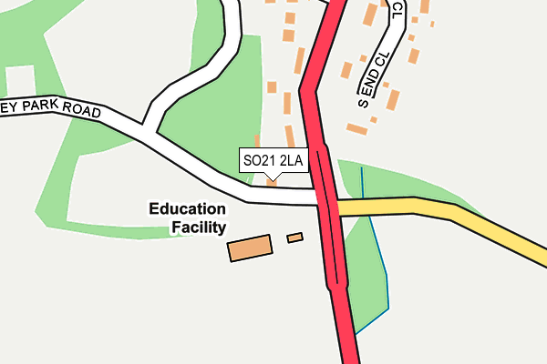
SO21 2LA lies on Hursley Park Road in Hursley, Winchester. SO21 2LA is located in the Badger Farm and Oliver's Battery electoral ward, within the local authority district of Winchester and the English Parliamentary constituency of Winchester. The Sub Integrated Care Board (ICB) Location is NHS Hampshire and Isle of Wight ICB - D9Y0V and the police force is Hampshire. This postcode has been in use since January 1980.


GetTheData
Source: OS OpenMap – Local (Ordnance Survey)
Source: OS VectorMap District (Ordnance Survey)
Licence: Open Government Licence (requires attribution)
| Easting | 442722 |
| Northing | 124852 |
| Latitude | 51.021460 |
| Longitude | -1.392270 |
GetTheData
Source: Open Postcode Geo
Licence: Open Government Licence
| Street | Hursley Park Road |
| Locality | Hursley |
| Town/City | Winchester |
| Country | England |
| Postcode District | SO21 |
➜ See where SO21 is on a map ➜ Where is Hursley? | |
GetTheData
Source: Land Registry Price Paid Data
Licence: Open Government Licence
Elevation or altitude of SO21 2LA as distance above sea level:
| Metres | Feet | |
|---|---|---|
| Elevation | 50m | 164ft |
Elevation is measured from the approximate centre of the postcode, to the nearest point on an OS contour line from OS Terrain 50, which has contour spacing of ten vertical metres.
➜ How high above sea level am I? Find the elevation of your current position using your device's GPS.
GetTheData
Source: Open Postcode Elevation
Licence: Open Government Licence
| Ward | Badger Farm And Oliver's Battery |
| Constituency | Winchester |
GetTheData
Source: ONS Postcode Database
Licence: Open Government Licence
2024 2 OCT £1,400,000 |
2005 1 JUL £790,000 |
CEDARS, HURSLEY PARK ROAD, HURSLEY, WINCHESTER, SO21 2LA 2001 19 DEC £310,000 |
GetTheData
Source: HM Land Registry Price Paid Data
Licence: Contains HM Land Registry data © Crown copyright and database right 2025. This data is licensed under the Open Government Licence v3.0.
| John Keble Primary School (Hursley Park Road) | Hursley | 46m |
| Poles Lane | Hursley | 48m |
| Poles Lane | Hursley | 66m |
| Kings Head Inn (A3090) | Hursley | 442m |
| Kings Head Inn (A3090) | Hursley | 488m |
| Chandlers Ford Station | 4.2km |
| Shawford Station | 4.5km |
GetTheData
Source: NaPTAN
Licence: Open Government Licence
| Percentage of properties with Next Generation Access | 100.0% |
| Percentage of properties with Superfast Broadband | 100.0% |
| Percentage of properties with Ultrafast Broadband | 0.0% |
| Percentage of properties with Full Fibre Broadband | 0.0% |
Superfast Broadband is between 30Mbps and 300Mbps
Ultrafast Broadband is > 300Mbps
| Percentage of properties unable to receive 2Mbps | 0.0% |
| Percentage of properties unable to receive 5Mbps | 0.0% |
| Percentage of properties unable to receive 10Mbps | 0.0% |
| Percentage of properties unable to receive 30Mbps | 0.0% |
GetTheData
Source: Ofcom
Licence: Ofcom Terms of Use (requires attribution)
GetTheData
Source: ONS Postcode Database
Licence: Open Government Licence


➜ Get more ratings from the Food Standards Agency
GetTheData
Source: Food Standards Agency
Licence: FSA terms & conditions
| Last Collection | |||
|---|---|---|---|
| Location | Mon-Fri | Sat | Distance |
| Hursley Post Office | 16:30 | 09:30 | 429m |
| Silkstead | 16:30 | 08:45 | 1,917m |
| Lower Standen | 16:00 | 07:00 | 2,001m |
GetTheData
Source: Dracos
Licence: Creative Commons Attribution-ShareAlike
The below table lists the International Territorial Level (ITL) codes (formerly Nomenclature of Territorial Units for Statistics (NUTS) codes) and Local Administrative Units (LAU) codes for SO21 2LA:
| ITL 1 Code | Name |
|---|---|
| TLJ | South East (England) |
| ITL 2 Code | Name |
| TLJ3 | Hampshire and Isle of Wight |
| ITL 3 Code | Name |
| TLJ36 | Central Hampshire |
| LAU 1 Code | Name |
| E07000094 | Winchester |
GetTheData
Source: ONS Postcode Directory
Licence: Open Government Licence
The below table lists the Census Output Area (OA), Lower Layer Super Output Area (LSOA), and Middle Layer Super Output Area (MSOA) for SO21 2LA:
| Code | Name | |
|---|---|---|
| OA | E00118028 | |
| LSOA | E01023229 | Winchester 009A |
| MSOA | E02004837 | Winchester 009 |
GetTheData
Source: ONS Postcode Directory
Licence: Open Government Licence
| SO21 2LJ | South End Close | 208m |
| SO21 2JA | Meredun Close | 298m |
| SO21 2JY | Main Road | 317m |
| SO21 2JB | Meredun Close | 332m |
| SO21 2JX | Collins Lane | 463m |
| SO21 2JQ | Sussex Close | 518m |
| SO21 2JS | Port Lane | 539m |
| SO21 2LH | Heathcote Place | 542m |
| SO21 2JT | Catways | 592m |
| SO21 2JW | Main Road | 639m |
GetTheData
Source: Open Postcode Geo; Land Registry Price Paid Data
Licence: Open Government Licence