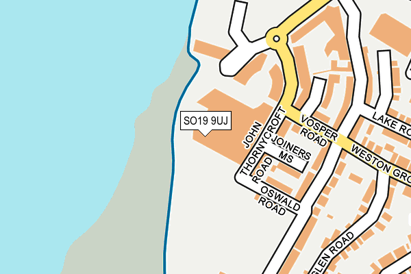
SO19 9UJ is located in the Woolston electoral ward, within the unitary authority of Southampton and the English Parliamentary constituency of Southampton, Itchen. The Sub Integrated Care Board (ICB) Location is NHS Hampshire and Isle of Wight ICB - D9Y0V and the police force is Hampshire. This postcode has been in use since May 2016.


GetTheData
Source: OS OpenMap – Local (Ordnance Survey)
Source: OS VectorMap District (Ordnance Survey)
Licence: Open Government Licence (requires attribution)
| Easting | 443461 |
| Northing | 110686 |
| Latitude | 50.894018 |
| Longitude | -1.383413 |
GetTheData
Source: Open Postcode Geo
Licence: Open Government Licence
| Country | England |
| Postcode District | SO19 |
➜ See where SO19 is on a map ➜ Where is Southampton? | |
GetTheData
Source: Land Registry Price Paid Data
Licence: Open Government Licence
Elevation or altitude of SO19 9UJ as distance above sea level:
| Metres | Feet | |
|---|---|---|
| Elevation | 0m | 0ft |
Elevation is measured from the approximate centre of the postcode, to the nearest point on an OS contour line from OS Terrain 50, which has contour spacing of ten vertical metres.
➜ How high above sea level am I? Find the elevation of your current position using your device's GPS.
GetTheData
Source: Open Postcode Elevation
Licence: Open Government Licence
| Ward | Woolston |
| Constituency | Southampton, Itchen |
GetTheData
Source: ONS Postcode Database
Licence: Open Government Licence
| The Ship Inn (Vosper Road) | Woolston | 153m |
| Centenary Quay (John Thorneycroft Road) | Woolston | 158m |
| The Ship Inn (Victoria Road) | Woolston | 182m |
| Centenary Quay (John Thorneycroft Road) | Woolston | 223m |
| Swift Road (Victoria Road) | Woolston | 321m |
| Woolston Station | 0.7km |
| Sholing Station | 1.3km |
| Southampton Town Quay | 1.6km |
GetTheData
Source: NaPTAN
Licence: Open Government Licence
| Percentage of properties with Next Generation Access | 100.0% |
| Percentage of properties with Superfast Broadband | 100.0% |
| Percentage of properties with Ultrafast Broadband | 100.0% |
| Percentage of properties with Full Fibre Broadband | 100.0% |
Superfast Broadband is between 30Mbps and 300Mbps
Ultrafast Broadband is > 300Mbps
| Median download speed | 16.9Mbps |
| Average download speed | 15.5Mbps |
| Maximum download speed | 20.01Mbps |
| Median upload speed | 1.1Mbps |
| Average upload speed | 1.1Mbps |
| Maximum upload speed | 1.29Mbps |
| Percentage of properties unable to receive 2Mbps | 0.0% |
| Percentage of properties unable to receive 5Mbps | 0.0% |
| Percentage of properties unable to receive 10Mbps | 0.0% |
| Percentage of properties unable to receive 30Mbps | 0.0% |
GetTheData
Source: Ofcom
Licence: Ofcom Terms of Use (requires attribution)
GetTheData
Source: ONS Postcode Database
Licence: Open Government Licence


➜ Get more ratings from the Food Standards Agency
GetTheData
Source: Food Standards Agency
Licence: FSA terms & conditions
| Last Collection | |||
|---|---|---|---|
| Location | Mon-Fri | Sat | Distance |
| Victoria Road | 17:45 | 12:00 | 337m |
| Weston Grove Road | 17:30 | 12:00 | 457m |
| Obelisk Road | 17:30 | 12:00 | 524m |
GetTheData
Source: Dracos
Licence: Creative Commons Attribution-ShareAlike
The below table lists the International Territorial Level (ITL) codes (formerly Nomenclature of Territorial Units for Statistics (NUTS) codes) and Local Administrative Units (LAU) codes for SO19 9UJ:
| ITL 1 Code | Name |
|---|---|
| TLJ | South East (England) |
| ITL 2 Code | Name |
| TLJ3 | Hampshire and Isle of Wight |
| ITL 3 Code | Name |
| TLJ32 | Southampton |
| LAU 1 Code | Name |
| E06000045 | Southampton |
GetTheData
Source: ONS Postcode Directory
Licence: Open Government Licence
The below table lists the Census Output Area (OA), Lower Layer Super Output Area (LSOA), and Middle Layer Super Output Area (MSOA) for SO19 9UJ:
| Code | Name | |
|---|---|---|
| OA | E00087267 | |
| LSOA | E01017278 | Southampton 031D |
| MSOA | E02003579 | Southampton 031 |
GetTheData
Source: ONS Postcode Directory
Licence: Open Government Licence
| SO19 9UH | John Thornycroft Road | 45m |
| SO19 9SP | John Thornycroft Road | 97m |
| SO19 9UE | Centenary Plaza | 105m |
| SO19 9UD | Centenary Plaza | 124m |
| SO19 9SQ | Oswald Road | 127m |
| SO19 9SR | Joiners Mews | 127m |
| SO19 9TW | John Thornycroft Road | 142m |
| SO19 9TS | John Thornycroft Road | 147m |
| SO19 9SS | Vosper Road | 147m |
| SO19 9TQ | John Thornycroft Road | 158m |
GetTheData
Source: Open Postcode Geo; Land Registry Price Paid Data
Licence: Open Government Licence