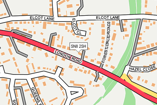
SN8 2SH lies on Laurel Drive in Marlborough. SN8 2SH is located in the Marlborough East electoral ward, within the unitary authority of Wiltshire and the English Parliamentary constituency of Devizes. The Sub Integrated Care Board (ICB) Location is NHS Bath and North East Somerset, Swindon and Wiltshire ICB - 92 and the police force is Wiltshire. This postcode has been in use since January 1993.


GetTheData
Source: OS OpenMap – Local (Ordnance Survey)
Source: OS VectorMap District (Ordnance Survey)
Licence: Open Government Licence (requires attribution)
| Easting | 419966 |
| Northing | 168973 |
| Latitude | 51.419423 |
| Longitude | -1.714262 |
GetTheData
Source: Open Postcode Geo
Licence: Open Government Licence
| Street | Laurel Drive |
| Town/City | Marlborough |
| Country | England |
| Postcode District | SN8 |
➜ See where SN8 is on a map ➜ Where is Marlborough? | |
GetTheData
Source: Land Registry Price Paid Data
Licence: Open Government Licence
Elevation or altitude of SN8 2SH as distance above sea level:
| Metres | Feet | |
|---|---|---|
| Elevation | 140m | 459ft |
Elevation is measured from the approximate centre of the postcode, to the nearest point on an OS contour line from OS Terrain 50, which has contour spacing of ten vertical metres.
➜ How high above sea level am I? Find the elevation of your current position using your device's GPS.
GetTheData
Source: Open Postcode Elevation
Licence: Open Government Licence
| Ward | Marlborough East |
| Constituency | Devizes |
GetTheData
Source: ONS Postcode Database
Licence: Open Government Licence
2014 19 AUG £675,000 |
2008 8 SEP £585,000 |
4, LAUREL DRIVE, MARLBOROUGH, SN8 2SH 2001 28 SEP £225,000 |
1, LAUREL DRIVE, MARLBOROUGH, SN8 2SH 1999 30 JUN £220,000 |
4, LAUREL DRIVE, MARLBOROUGH, SN8 2SH 1996 9 SEP £105,000 |
GetTheData
Source: HM Land Registry Price Paid Data
Licence: Contains HM Land Registry data © Crown copyright and database right 2025. This data is licensed under the Open Government Licence v3.0.
| Savernake Crescent (Five Stiles Road) | Marlborough | 181m |
| Barnfield (London Road) | Marlborough | 221m |
| Barnfield (Marlborough Road) | Marlborough | 222m |
| Roebuck (London Road) | Marlborough | 253m |
| Roebuck (London Road) | Marlborough | 270m |
GetTheData
Source: NaPTAN
Licence: Open Government Licence
| Percentage of properties with Next Generation Access | 100.0% |
| Percentage of properties with Superfast Broadband | 100.0% |
| Percentage of properties with Ultrafast Broadband | 0.0% |
| Percentage of properties with Full Fibre Broadband | 0.0% |
Superfast Broadband is between 30Mbps and 300Mbps
Ultrafast Broadband is > 300Mbps
| Percentage of properties unable to receive 2Mbps | 0.0% |
| Percentage of properties unable to receive 5Mbps | 0.0% |
| Percentage of properties unable to receive 10Mbps | 0.0% |
| Percentage of properties unable to receive 30Mbps | 0.0% |
GetTheData
Source: Ofcom
Licence: Ofcom Terms of Use (requires attribution)
GetTheData
Source: ONS Postcode Database
Licence: Open Government Licence


➜ Get more ratings from the Food Standards Agency
GetTheData
Source: Food Standards Agency
Licence: FSA terms & conditions
| Last Collection | |||
|---|---|---|---|
| Location | Mon-Fri | Sat | Distance |
| Barnfield | 17:30 | 12:00 | 197m |
| London Road | 17:45 | 12:00 | 408m |
| Priorsfield | 17:30 | 12:00 | 684m |
GetTheData
Source: Dracos
Licence: Creative Commons Attribution-ShareAlike
The below table lists the International Territorial Level (ITL) codes (formerly Nomenclature of Territorial Units for Statistics (NUTS) codes) and Local Administrative Units (LAU) codes for SN8 2SH:
| ITL 1 Code | Name |
|---|---|
| TLK | South West (England) |
| ITL 2 Code | Name |
| TLK1 | Gloucestershire, Wiltshire and Bath/Bristol area |
| ITL 3 Code | Name |
| TLK15 | Wiltshire |
| LAU 1 Code | Name |
| E06000054 | Wiltshire |
GetTheData
Source: ONS Postcode Directory
Licence: Open Government Licence
The below table lists the Census Output Area (OA), Lower Layer Super Output Area (LSOA), and Middle Layer Super Output Area (MSOA) for SN8 2SH:
| Code | Name | |
|---|---|---|
| OA | E00162504 | |
| LSOA | E01031861 | Wiltshire 019A |
| MSOA | E02006635 | Wiltshire 019 |
GetTheData
Source: ONS Postcode Directory
Licence: Open Government Licence
| SN8 2BB | Elcot Close | 62m |
| SN8 2AJ | London Road | 64m |
| SN8 4BL | Police Houses | 98m |
| SN8 2AR | London Road | 106m |
| SN8 2AS | Forest Dale Road | 113m |
| SN8 2BF | Chapter Close | 144m |
| SN8 4BG | Five Stiles Road | 145m |
| SN8 2BA | Elcot Lane | 147m |
| SN8 4BJ | Savernake Crescent | 151m |
| SN8 2AN | London Road | 155m |
GetTheData
Source: Open Postcode Geo; Land Registry Price Paid Data
Licence: Open Government Licence