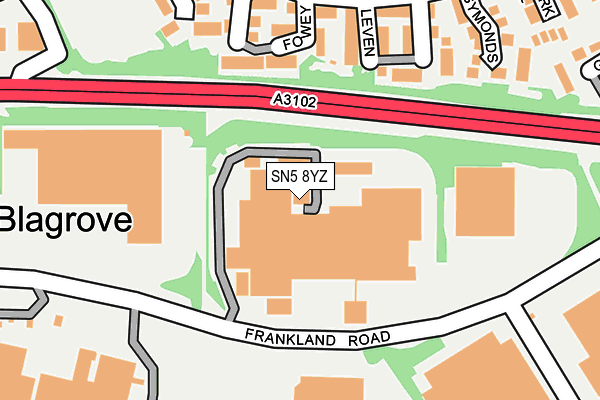
SN5 8YZ lies on Clearwater Business Park in Blagrove, Swindon. SN5 8YZ is located in the Lydiard and Freshbrook electoral ward, within the unitary authority of Swindon and the English Parliamentary constituency of South Swindon. The Sub Integrated Care Board (ICB) Location is NHS Bath and North East Somerset, Swindon and Wiltshire ICB - 92 and the police force is Wiltshire. This postcode has been in use since November 2004.


GetTheData
Source: OS OpenMap – Local (Ordnance Survey)
Source: OS VectorMap District (Ordnance Survey)
Licence: Open Government Licence (requires attribution)
| Easting | 411400 |
| Northing | 183027 |
| Latitude | 51.546025 |
| Longitude | -1.836988 |
GetTheData
Source: Open Postcode Geo
Licence: Open Government Licence
| Street | Clearwater Business Park |
| Locality | Blagrove |
| Town/City | Swindon |
| Country | England |
| Postcode District | SN5 |
➜ See where SN5 is on a map ➜ Where is Swindon? | |
GetTheData
Source: Land Registry Price Paid Data
Licence: Open Government Licence
Elevation or altitude of SN5 8YZ as distance above sea level:
| Metres | Feet | |
|---|---|---|
| Elevation | 100m | 328ft |
Elevation is measured from the approximate centre of the postcode, to the nearest point on an OS contour line from OS Terrain 50, which has contour spacing of ten vertical metres.
➜ How high above sea level am I? Find the elevation of your current position using your device's GPS.
GetTheData
Source: Open Postcode Elevation
Licence: Open Government Licence
| Ward | Lydiard And Freshbrook |
| Constituency | South Swindon |
GetTheData
Source: ONS Postcode Database
Licence: Open Government Licence
| Blagrove Man (Frankland Road) | Blagrove | 136m |
| Blagrove Man (Frankland Road) | Blagrove | 142m |
| Water Research Council (Frankland Road) | Blagrove | 231m |
| Desborough (Worsley Road) | Freshbrook | 251m |
| Symonds (Worsley Road) | Freshbrook | 257m |
| Swindon Station | 4.2km |
GetTheData
Source: NaPTAN
Licence: Open Government Licence
| Median download speed | 6.7Mbps |
| Average download speed | 5.9Mbps |
| Maximum download speed | 9.05Mbps |
| Median upload speed | 1.0Mbps |
| Average upload speed | 1.0Mbps |
| Maximum upload speed | 1.20Mbps |
GetTheData
Source: Ofcom
Licence: Ofcom Terms of Use (requires attribution)
GetTheData
Source: ONS Postcode Database
Licence: Open Government Licence


➜ Get more ratings from the Food Standards Agency
GetTheData
Source: Food Standards Agency
Licence: FSA terms & conditions
| Last Collection | |||
|---|---|---|---|
| Location | Mon-Fri | Sat | Distance |
| Freshbrook Post Office | 18:45 | 12:00 | 545m |
| Gainsborough Way | 17:30 | 12:00 | 653m |
| Sn5 Euroway Stamped Swinodn | 18:45 | 12:45 | 740m |
GetTheData
Source: Dracos
Licence: Creative Commons Attribution-ShareAlike
The below table lists the International Territorial Level (ITL) codes (formerly Nomenclature of Territorial Units for Statistics (NUTS) codes) and Local Administrative Units (LAU) codes for SN5 8YZ:
| ITL 1 Code | Name |
|---|---|
| TLK | South West (England) |
| ITL 2 Code | Name |
| TLK1 | Gloucestershire, Wiltshire and Bath/Bristol area |
| ITL 3 Code | Name |
| TLK14 | Swindon |
| LAU 1 Code | Name |
| E06000030 | Swindon |
GetTheData
Source: ONS Postcode Directory
Licence: Open Government Licence
The below table lists the Census Output Area (OA), Lower Layer Super Output Area (LSOA), and Middle Layer Super Output Area (MSOA) for SN5 8YZ:
| Code | Name | |
|---|---|---|
| OA | E00078406 | |
| LSOA | E01015501 | Swindon 022A |
| MSOA | E02003233 | Swindon 022 |
GetTheData
Source: ONS Postcode Directory
Licence: Open Government Licence
| SN5 8QW | Leven | 170m |
| SN5 8QP | Fowey | 192m |
| SN5 8QN | Nantwich | 198m |
| SN5 8QL | Symonds | 210m |
| SN5 8QR | Desborough | 225m |
| SN5 8NU | Worsley Road | 237m |
| SN5 8NX | Newark Close | 265m |
| SN5 8QE | Fleetwood Court | 283m |
| SN5 8QF | Pendennis Road | 288m |
| SN5 8QS | Bevil | 289m |
GetTheData
Source: Open Postcode Geo; Land Registry Price Paid Data
Licence: Open Government Licence