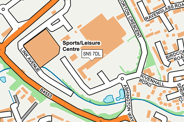
SN5 7DL is located in the Shaw electoral ward, within the unitary authority of Swindon and the English Parliamentary constituency of South Swindon. The Sub Integrated Care Board (ICB) Location is NHS Bath and North East Somerset, Swindon and Wiltshire ICB - 92 and the police force is Wiltshire. This postcode has been in use since September 1991.


GetTheData
Source: OS OpenMap – Local (Ordnance Survey)
Source: OS VectorMap District (Ordnance Survey)
Licence: Open Government Licence (requires attribution)
| Easting | 411975 |
| Northing | 184400 |
| Latitude | 51.558357 |
| Longitude | -1.828660 |
GetTheData
Source: Open Postcode Geo
Licence: Open Government Licence
| Country | England |
| Postcode District | SN5 |
➜ See where SN5 is on a map ➜ Where is Swindon? | |
GetTheData
Source: Land Registry Price Paid Data
Licence: Open Government Licence
Elevation or altitude of SN5 7DL as distance above sea level:
| Metres | Feet | |
|---|---|---|
| Elevation | 100m | 328ft |
Elevation is measured from the approximate centre of the postcode, to the nearest point on an OS contour line from OS Terrain 50, which has contour spacing of ten vertical metres.
➜ How high above sea level am I? Find the elevation of your current position using your device's GPS.
GetTheData
Source: Open Postcode Elevation
Licence: Open Government Licence
| Ward | Shaw |
| Constituency | South Swindon |
GetTheData
Source: ONS Postcode Database
Licence: Open Government Licence
| West Swindon Centre (Ashington Way) | Westlea | 104m |
| Link Centre (Link Avenue) | Link Leisure Centre | 154m |
| Link Centre (Link Avenue) | Link Leisure Centre | 156m |
| West Swindon Centre (Corton Crescent) | Westlea | 162m |
| West Swindon Centre (Corton Crescent) | Westlea | 165m |
| Swindon Station | 3.1km |
GetTheData
Source: NaPTAN
Licence: Open Government Licence
| Median download speed | 14.6Mbps |
| Average download speed | 12.4Mbps |
| Maximum download speed | 16.97Mbps |
| Median upload speed | 1.0Mbps |
| Average upload speed | 1.1Mbps |
| Maximum upload speed | 1.22Mbps |
GetTheData
Source: Ofcom
Licence: Ofcom Terms of Use (requires attribution)
GetTheData
Source: ONS Postcode Database
Licence: Open Government Licence


➜ Get more ratings from the Food Standards Agency
GetTheData
Source: Food Standards Agency
Licence: FSA terms & conditions
| Last Collection | |||
|---|---|---|---|
| Location | Mon-Fri | Sat | Distance |
| West Swindon Centre P.o | 17:30 | 12:00 | 65m |
| Westlea Drive | 17:45 | 12:45 | 378m |
| Idovers Drive | 17:30 | 12:00 | 525m |
GetTheData
Source: Dracos
Licence: Creative Commons Attribution-ShareAlike
The below table lists the International Territorial Level (ITL) codes (formerly Nomenclature of Territorial Units for Statistics (NUTS) codes) and Local Administrative Units (LAU) codes for SN5 7DL:
| ITL 1 Code | Name |
|---|---|
| TLK | South West (England) |
| ITL 2 Code | Name |
| TLK1 | Gloucestershire, Wiltshire and Bath/Bristol area |
| ITL 3 Code | Name |
| TLK14 | Swindon |
| LAU 1 Code | Name |
| E06000030 | Swindon |
GetTheData
Source: ONS Postcode Directory
Licence: Open Government Licence
The below table lists the Census Output Area (OA), Lower Layer Super Output Area (LSOA), and Middle Layer Super Output Area (MSOA) for SN5 7DL:
| Code | Name | |
|---|---|---|
| OA | E00078739 | |
| LSOA | E01015569 | Swindon 022D |
| MSOA | E02003233 | Swindon 022 |
GetTheData
Source: ONS Postcode Directory
Licence: Open Government Licence
| SN5 7DQ | The Forum | 202m |
| SN5 7BL | Birdcombe Road | 245m |
| SN5 8LD | Stamford Close | 246m |
| SN5 8LG | Edington Close | 253m |
| SN5 7BN | Ravenglass Road | 259m |
| SN5 7BJ | Birdcombe Road | 266m |
| SN5 7BW | Ravenglass Road | 269m |
| SN5 7DR | Heronbridge Close | 272m |
| SN5 7AZ | Risingham Mead | 294m |
| SN5 7DY | Silchester Way | 312m |
GetTheData
Source: Open Postcode Geo; Land Registry Price Paid Data
Licence: Open Government Licence