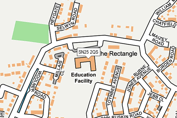
SN25 2QS is located in the St Andrews electoral ward, within the unitary authority of Swindon and the English Parliamentary constituency of North Swindon. The Sub Integrated Care Board (ICB) Location is NHS Bath and North East Somerset, Swindon and Wiltshire ICB - 92 and the police force is Wiltshire. This postcode has been in use since July 2015.


GetTheData
Source: OS OpenMap – Local (Ordnance Survey)
Source: OS VectorMap District (Ordnance Survey)
Licence: Open Government Licence (requires attribution)
| Easting | 412388 |
| Northing | 190161 |
| Latitude | 51.610147 |
| Longitude | -1.822501 |
GetTheData
Source: Open Postcode Geo
Licence: Open Government Licence
| Country | England |
| Postcode District | SN25 |
➜ See where SN25 is on a map ➜ Where is Swindon? | |
GetTheData
Source: Land Registry Price Paid Data
Licence: Open Government Licence
Elevation or altitude of SN25 2QS as distance above sea level:
| Metres | Feet | |
|---|---|---|
| Elevation | 90m | 295ft |
Elevation is measured from the approximate centre of the postcode, to the nearest point on an OS contour line from OS Terrain 50, which has contour spacing of ten vertical metres.
➜ How high above sea level am I? Find the elevation of your current position using your device's GPS.
GetTheData
Source: Open Postcode Elevation
Licence: Open Government Licence
| Ward | St Andrews |
| Constituency | North Swindon |
GetTheData
Source: ONS Postcode Database
Licence: Open Government Licence
| Tortworth Road (Redhouse Way) | Redhouse | 806m |
| Tortworth Road (Redhouse Way) | Redhouse | 846m |
| Isambard School (Redhouse Way) | Redhouse | 877m |
| Birkdale Close (Redhouse Way) | Redhouse | 913m |
| Birkdale Close (Redhouse Way) | Redhouse | 922m |
| Swindon Station | 5.6km |
GetTheData
Source: NaPTAN
Licence: Open Government Licence
GetTheData
Source: ONS Postcode Database
Licence: Open Government Licence


➜ Get more ratings from the Food Standards Agency
GetTheData
Source: Food Standards Agency
Licence: FSA terms & conditions
| Last Collection | |||
|---|---|---|---|
| Location | Mon-Fri | Sat | Distance |
| Oakhurst Way | 17:30 | 12:15 | 977m |
| Saltzgitter Drive | 17:30 | 12:00 | 1,665m |
| Asda(Walmart) | 18:30 | 12:15 | 1,766m |
GetTheData
Source: Dracos
Licence: Creative Commons Attribution-ShareAlike
The below table lists the International Territorial Level (ITL) codes (formerly Nomenclature of Territorial Units for Statistics (NUTS) codes) and Local Administrative Units (LAU) codes for SN25 2QS:
| ITL 1 Code | Name |
|---|---|
| TLK | South West (England) |
| ITL 2 Code | Name |
| TLK1 | Gloucestershire, Wiltshire and Bath/Bristol area |
| ITL 3 Code | Name |
| TLK14 | Swindon |
| LAU 1 Code | Name |
| E06000030 | Swindon |
GetTheData
Source: ONS Postcode Directory
Licence: Open Government Licence
The below table lists the Census Output Area (OA), Lower Layer Super Output Area (LSOA), and Middle Layer Super Output Area (MSOA) for SN25 2QS:
| Code | Name | |
|---|---|---|
| OA | E00078246 | |
| LSOA | E01015474 | Swindon 008B |
| MSOA | E02003219 | Swindon 008 |
GetTheData
Source: ONS Postcode Directory
Licence: Open Government Licence
| SN25 2QG | Burne Jones Avenue | 179m |
| SN25 2PS | John Ruskin Road | 190m |
| SN25 2PT | William Morris Way | 206m |
| SN25 2QJ | Eglantyne Avenue | 214m |
| SN25 2PU | John Ruskin Road | 237m |
| SN25 2QX | Artisans Lane | 260m |
| SN25 2QN | Jebb Close | 279m |
| SN25 2QT | Rackham Close | 317m |
| SN25 2PP | William Morris Way | 322m |
| SN25 2PZ | De Morgan Crescent | 398m |
GetTheData
Source: Open Postcode Geo; Land Registry Price Paid Data
Licence: Open Government Licence