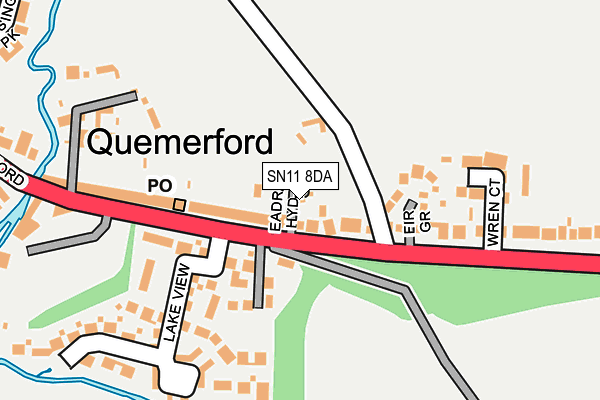
SN11 8DA lies on Eadreds Hyde in Calne. SN11 8DA is located in the Calne South electoral ward, within the unitary authority of Wiltshire and the English Parliamentary constituency of North Wiltshire. The Sub Integrated Care Board (ICB) Location is NHS Bath and North East Somerset, Swindon and Wiltshire ICB - 92 and the police force is Wiltshire. This postcode has been in use since March 2007.


GetTheData
Source: OS OpenMap – Local (Ordnance Survey)
Source: OS VectorMap District (Ordnance Survey)
Licence: Open Government Licence (requires attribution)
| Easting | 400900 |
| Northing | 169760 |
| Latitude | 51.426846 |
| Longitude | -1.988445 |
GetTheData
Source: Open Postcode Geo
Licence: Open Government Licence
| Street | Eadreds Hyde |
| Town/City | Calne |
| Country | England |
| Postcode District | SN11 |
➜ See where SN11 is on a map ➜ Where is Calne? | |
GetTheData
Source: Land Registry Price Paid Data
Licence: Open Government Licence
Elevation or altitude of SN11 8DA as distance above sea level:
| Metres | Feet | |
|---|---|---|
| Elevation | 80m | 262ft |
Elevation is measured from the approximate centre of the postcode, to the nearest point on an OS contour line from OS Terrain 50, which has contour spacing of ten vertical metres.
➜ How high above sea level am I? Find the elevation of your current position using your device's GPS.
GetTheData
Source: Open Postcode Elevation
Licence: Open Government Licence
| Ward | Calne South |
| Constituency | North Wiltshire |
GetTheData
Source: ONS Postcode Database
Licence: Open Government Licence
| Post Office (Quemerford) | Quemerford | 79m |
| Post Office (Quemerford) | Quemerford | 127m |
| Stockley Lane (Quemerford) | Quemerford | 278m |
| Stockley Lane (Quemerford) | Quemerford | 330m |
| Ebor Paddock (Riverside) | Calne | 378m |
GetTheData
Source: NaPTAN
Licence: Open Government Licence
| Percentage of properties with Next Generation Access | 100.0% |
| Percentage of properties with Superfast Broadband | 100.0% |
| Percentage of properties with Ultrafast Broadband | 0.0% |
| Percentage of properties with Full Fibre Broadband | 0.0% |
Superfast Broadband is between 30Mbps and 300Mbps
Ultrafast Broadband is > 300Mbps
| Percentage of properties unable to receive 2Mbps | 0.0% |
| Percentage of properties unable to receive 5Mbps | 0.0% |
| Percentage of properties unable to receive 10Mbps | 0.0% |
| Percentage of properties unable to receive 30Mbps | 0.0% |
GetTheData
Source: Ofcom
Licence: Ofcom Terms of Use (requires attribution)
GetTheData
Source: ONS Postcode Database
Licence: Open Government Licence


➜ Get more ratings from the Food Standards Agency
GetTheData
Source: Food Standards Agency
Licence: FSA terms & conditions
| Last Collection | |||
|---|---|---|---|
| Location | Mon-Fri | Sat | Distance |
| Quemerford Post Office | 17:30 | 12:00 | 139m |
| Wessington Park | 17:30 | 12:00 | 461m |
| Quemerford Common | 17:30 | 12:00 | 464m |
GetTheData
Source: Dracos
Licence: Creative Commons Attribution-ShareAlike
The below table lists the International Territorial Level (ITL) codes (formerly Nomenclature of Territorial Units for Statistics (NUTS) codes) and Local Administrative Units (LAU) codes for SN11 8DA:
| ITL 1 Code | Name |
|---|---|
| TLK | South West (England) |
| ITL 2 Code | Name |
| TLK1 | Gloucestershire, Wiltshire and Bath/Bristol area |
| ITL 3 Code | Name |
| TLK15 | Wiltshire |
| LAU 1 Code | Name |
| E06000054 | Wiltshire |
GetTheData
Source: ONS Postcode Directory
Licence: Open Government Licence
The below table lists the Census Output Area (OA), Lower Layer Super Output Area (LSOA), and Middle Layer Super Output Area (MSOA) for SN11 8DA:
| Code | Name | |
|---|---|---|
| OA | E00162729 | |
| LSOA | E01031903 | Wiltshire 016D |
| MSOA | E02006658 | Wiltshire 016 |
GetTheData
Source: ONS Postcode Directory
Licence: Open Government Licence
| SN11 8JY | Quemerford | 51m |
| SN11 8JZ | Quemerford | 88m |
| SN11 8JX | Quemerford | 119m |
| SN11 8JL | Fir Grove | 121m |
| SN11 8JA | Lake View | 180m |
| SN11 8LW | Wren Court | 184m |
| SN11 8JU | Quemerford | 220m |
| SN11 8LA | Quemerford | 254m |
| SN11 8JT | Quemerford | 257m |
| SN11 8UA | Quemerford | 264m |
GetTheData
Source: Open Postcode Geo; Land Registry Price Paid Data
Licence: Open Government Licence