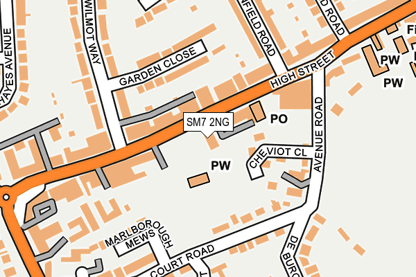
SM7 2NG lies on High Street in Banstead. SM7 2NG is located in the Banstead Village electoral ward, within the local authority district of Reigate and Banstead and the English Parliamentary constituency of Reigate. The Sub Integrated Care Board (ICB) Location is NHS Surrey Heartlands ICB - 92A and the police force is Surrey. This postcode has been in use since December 1997.


GetTheData
Source: OS OpenMap – Local (Ordnance Survey)
Source: OS VectorMap District (Ordnance Survey)
Licence: Open Government Licence (requires attribution)
| Easting | 525486 |
| Northing | 159699 |
| Latitude | 51.322562 |
| Longitude | -0.200534 |
GetTheData
Source: Open Postcode Geo
Licence: Open Government Licence
| Street | High Street |
| Town/City | Banstead |
| Country | England |
| Postcode District | SM7 |
➜ See where SM7 is on a map ➜ Where is Banstead? | |
GetTheData
Source: Land Registry Price Paid Data
Licence: Open Government Licence
Elevation or altitude of SM7 2NG as distance above sea level:
| Metres | Feet | |
|---|---|---|
| Elevation | 160m | 525ft |
Elevation is measured from the approximate centre of the postcode, to the nearest point on an OS contour line from OS Terrain 50, which has contour spacing of ten vertical metres.
➜ How high above sea level am I? Find the elevation of your current position using your device's GPS.
GetTheData
Source: Open Postcode Elevation
Licence: Open Government Licence
| Ward | Banstead Village |
| Constituency | Reigate |
GetTheData
Source: ONS Postcode Database
Licence: Open Government Licence
| Glenfield Road (Banstead High Street) | Banstead | 67m |
| Glenfield Road (Banstead High Street) | Banstead | 134m |
| Marks And Spencer (Banstead High Street) | Banstead | 205m |
| Marks And Spencer (Banstead High Street) | Banstead | 254m |
| The Woolpack (Banstead High Street) | Banstead | 337m |
| Banstead Station | 1.2km |
| Belmont Station | 2.4km |
| Chipstead Station | 2.6km |
GetTheData
Source: NaPTAN
Licence: Open Government Licence
GetTheData
Source: ONS Postcode Database
Licence: Open Government Licence


➜ Get more ratings from the Food Standards Agency
GetTheData
Source: Food Standards Agency
Licence: FSA terms & conditions
| Last Collection | |||
|---|---|---|---|
| Location | Mon-Fri | Sat | Distance |
| Avenue Road (1) | 17:15 | 12:00 | 172m |
| Court Road (12) | 18:30 | 11:45 | 237m |
| Garratts Lane (31) | 17:30 | 12:00 | 631m |
GetTheData
Source: Dracos
Licence: Creative Commons Attribution-ShareAlike
The below table lists the International Territorial Level (ITL) codes (formerly Nomenclature of Territorial Units for Statistics (NUTS) codes) and Local Administrative Units (LAU) codes for SM7 2NG:
| ITL 1 Code | Name |
|---|---|
| TLJ | South East (England) |
| ITL 2 Code | Name |
| TLJ2 | Surrey, East and West Sussex |
| ITL 3 Code | Name |
| TLJ26 | East Surrey |
| LAU 1 Code | Name |
| E07000211 | Reigate and Banstead |
GetTheData
Source: ONS Postcode Directory
Licence: Open Government Licence
The below table lists the Census Output Area (OA), Lower Layer Super Output Area (LSOA), and Middle Layer Super Output Area (MSOA) for SM7 2NG:
| Code | Name | |
|---|---|---|
| OA | E00155883 | |
| LSOA | E01030560 | Reigate and Banstead 002B |
| MSOA | E02006376 | Reigate and Banstead 002 |
GetTheData
Source: ONS Postcode Directory
Licence: Open Government Licence
| SM7 2NL | High Street | 53m |
| SM7 2NN | High Street | 64m |
| SM7 2PD | Cheviot Close | 87m |
| SM7 2QB | Garden Close | 105m |
| SM7 2LX | High Street | 117m |
| SM7 2NQ | Court Road | 121m |
| SM7 2PE | Avenue Road | 135m |
| SM7 2PB | Avenue Road | 138m |
| SM7 2PF | Avenue Road | 143m |
| SM7 2PW | Court Road | 164m |
GetTheData
Source: Open Postcode Geo; Land Registry Price Paid Data
Licence: Open Government Licence