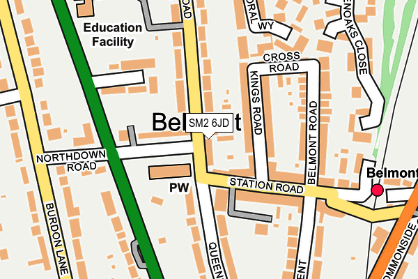
SM2 6JD lies on Avenue Road in Sutton. SM2 6JD is located in the Belmont electoral ward, within the London borough of Sutton and the English Parliamentary constituency of Sutton and Cheam. The Sub Integrated Care Board (ICB) Location is NHS South West London ICB - 36L and the police force is Metropolitan Police. This postcode has been in use since January 1980.


GetTheData
Source: OS OpenMap – Local (Ordnance Survey)
Source: OS VectorMap District (Ordnance Survey)
Licence: Open Government Licence (requires attribution)
| Easting | 525298 |
| Northing | 162140 |
| Latitude | 51.344540 |
| Longitude | -0.202348 |
GetTheData
Source: Open Postcode Geo
Licence: Open Government Licence
| Street | Avenue Road |
| Town/City | Sutton |
| Country | England |
| Postcode District | SM2 |
➜ See where SM2 is on a map ➜ Where is London? | |
GetTheData
Source: Land Registry Price Paid Data
Licence: Open Government Licence
Elevation or altitude of SM2 6JD as distance above sea level:
| Metres | Feet | |
|---|---|---|
| Elevation | 90m | 295ft |
Elevation is measured from the approximate centre of the postcode, to the nearest point on an OS contour line from OS Terrain 50, which has contour spacing of ten vertical metres.
➜ How high above sea level am I? Find the elevation of your current position using your device's GPS.
GetTheData
Source: Open Postcode Elevation
Licence: Open Government Licence
| Ward | Belmont |
| Constituency | Sutton And Cheam |
GetTheData
Source: ONS Postcode Database
Licence: Open Government Licence
| Station Road Avenue Road | Belmont | 30m |
| Belmont Station Road (Station Road) | Belmont | 80m |
| Belmont Station Road (Station Road) | Belmont | 91m |
| Belmont | Belmont | 330m |
| Belmont Stn Brighton Road (Brighton Road) | Belmont | 338m |
| Belmont Station | 0.3km |
| Cheam Station | 1.5km |
| Sutton (London) Station | 1.8km |
GetTheData
Source: NaPTAN
Licence: Open Government Licence
| Percentage of properties with Next Generation Access | 100.0% |
| Percentage of properties with Superfast Broadband | 100.0% |
| Percentage of properties with Ultrafast Broadband | 100.0% |
| Percentage of properties with Full Fibre Broadband | 0.0% |
Superfast Broadband is between 30Mbps and 300Mbps
Ultrafast Broadband is > 300Mbps
| Median download speed | 80.0Mbps |
| Average download speed | 96.6Mbps |
| Maximum download speed | 350.00Mbps |
| Median upload speed | 2.6Mbps |
| Average upload speed | 8.1Mbps |
| Maximum upload speed | 20.00Mbps |
| Percentage of properties unable to receive 2Mbps | 0.0% |
| Percentage of properties unable to receive 5Mbps | 0.0% |
| Percentage of properties unable to receive 10Mbps | 0.0% |
| Percentage of properties unable to receive 30Mbps | 0.0% |
GetTheData
Source: Ofcom
Licence: Ofcom Terms of Use (requires attribution)
Estimated total energy consumption in SM2 6JD by fuel type, 2015.
| Consumption (kWh) | 247,733 |
|---|---|
| Meter count | 21 |
| Mean (kWh/meter) | 11,797 |
| Median (kWh/meter) | 14,566 |
| Consumption (kWh) | 57,745 |
|---|---|
| Meter count | 16 |
| Mean (kWh/meter) | 3,609 |
| Median (kWh/meter) | 2,376 |
GetTheData
Source: Postcode level gas estimates: 2015 (experimental)
Source: Postcode level electricity estimates: 2015 (experimental)
Licence: Open Government Licence
GetTheData
Source: ONS Postcode Database
Licence: Open Government Licence


➜ Get more ratings from the Food Standards Agency
GetTheData
Source: Food Standards Agency
Licence: FSA terms & conditions
| Last Collection | |||
|---|---|---|---|
| Location | Mon-Fri | Sat | Distance |
| Burdon Lane (113) | 17:15 | 12:00 | 236m |
| York Road (82) | 17:30 | 12:00 | 372m |
| Homeland Drive (Opp 29) | 18:00 | 11:30 | 477m |
GetTheData
Source: Dracos
Licence: Creative Commons Attribution-ShareAlike
The below table lists the International Territorial Level (ITL) codes (formerly Nomenclature of Territorial Units for Statistics (NUTS) codes) and Local Administrative Units (LAU) codes for SM2 6JD:
| ITL 1 Code | Name |
|---|---|
| TLI | London |
| ITL 2 Code | Name |
| TLI6 | Outer London - South |
| ITL 3 Code | Name |
| TLI63 | Merton, Kingston upon Thames and Sutton |
| LAU 1 Code | Name |
| E09000029 | Sutton |
GetTheData
Source: ONS Postcode Directory
Licence: Open Government Licence
The below table lists the Census Output Area (OA), Lower Layer Super Output Area (LSOA), and Middle Layer Super Output Area (MSOA) for SM2 6JD:
| Code | Name | |
|---|---|---|
| OA | E00020624 | |
| LSOA | E01004094 | Sutton 025B |
| MSOA | E02006836 | Sutton 025 |
GetTheData
Source: ONS Postcode Directory
Licence: Open Government Licence
| SM2 6DF | Station Road | 60m |
| SM2 6DG | Kings Road | 70m |
| SM2 6DY | Northdown Road | 93m |
| SM2 6DQ | California Close | 106m |
| SM2 6DX | Lymbourne Close | 128m |
| SM2 6BX | Station Road | 129m |
| SM2 6DJ | Cross Road | 135m |
| SM2 6BS | Station Road | 139m |
| SM2 6JB | Avenue Road | 171m |
| SM2 6BZ | Queens Road | 171m |
GetTheData
Source: Open Postcode Geo; Land Registry Price Paid Data
Licence: Open Government Licence