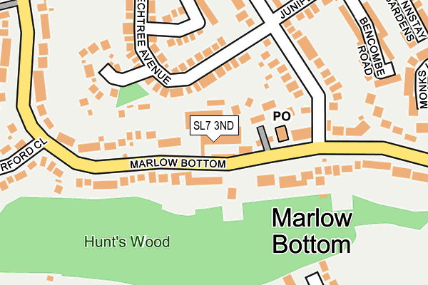
SL7 3ND is located in the Chiltern Villages electoral ward, within the unitary authority of Buckinghamshire and the English Parliamentary constituency of Wycombe. The Sub Integrated Care Board (ICB) Location is NHS Buckinghamshire, Oxfordshire and Berkshire West ICB - 14Y and the police force is Thames Valley. This postcode has been in use since January 1992.


GetTheData
Source: OS OpenMap – Local (Ordnance Survey)
Source: OS VectorMap District (Ordnance Survey)
Licence: Open Government Licence (requires attribution)
| Easting | 484797 |
| Northing | 188267 |
| Latitude | 51.586891 |
| Longitude | -0.777428 |
GetTheData
Source: Open Postcode Geo
Licence: Open Government Licence
| Country | England |
| Postcode District | SL7 |
➜ See where SL7 is on a map ➜ Where is Marlow Bottom? | |
GetTheData
Source: Land Registry Price Paid Data
Licence: Open Government Licence
Elevation or altitude of SL7 3ND as distance above sea level:
| Metres | Feet | |
|---|---|---|
| Elevation | 50m | 164ft |
Elevation is measured from the approximate centre of the postcode, to the nearest point on an OS contour line from OS Terrain 50, which has contour spacing of ten vertical metres.
➜ How high above sea level am I? Find the elevation of your current position using your device's GPS.
GetTheData
Source: Open Postcode Elevation
Licence: Open Government Licence
| Ward | Chiltern Villages |
| Constituency | Wycombe |
GetTheData
Source: ONS Postcode Database
Licence: Open Government Licence
| Post Office (Marlow Bottom) | Marlow Bottom | 118m |
| Post Office (Marlow Bottom) | Marlow Bottom | 120m |
| Burford School (Marlow Bottom) | Marlow Bottom | 265m |
| Burford School (Marlow Bottom) | Marlow Bottom | 280m |
| Patches Field (Marlow Bottom Road) | Marlow Bottom | 398m |
| Marlow Station | 1.9km |
| Bourne End Station | 4.8km |
| Cookham Station | 5km |
GetTheData
Source: NaPTAN
Licence: Open Government Licence
| Median download speed | 67.0Mbps |
| Average download speed | 48.2Mbps |
| Maximum download speed | 80.00Mbps |
| Median upload speed | 20.0Mbps |
| Average upload speed | 12.7Mbps |
| Maximum upload speed | 20.00Mbps |
GetTheData
Source: Ofcom
Licence: Ofcom Terms of Use (requires attribution)
GetTheData
Source: ONS Postcode Database
Licence: Open Government Licence


➜ Get more ratings from the Food Standards Agency
GetTheData
Source: Food Standards Agency
Licence: FSA terms & conditions
| Last Collection | |||
|---|---|---|---|
| Location | Mon-Fri | Sat | Distance |
| Marlow Bottom Post Office | 17:15 | 11:00 | 77m |
| Whitehill Marlow Bottom | 17:15 | 09:15 | 780m |
| Oaktree Road | 17:30 | 11:45 | 821m |
GetTheData
Source: Dracos
Licence: Creative Commons Attribution-ShareAlike
The below table lists the International Territorial Level (ITL) codes (formerly Nomenclature of Territorial Units for Statistics (NUTS) codes) and Local Administrative Units (LAU) codes for SL7 3ND:
| ITL 1 Code | Name |
|---|---|
| TLJ | South East (England) |
| ITL 2 Code | Name |
| TLJ1 | Berkshire, Buckinghamshire and Oxfordshire |
| ITL 3 Code | Name |
| TLJ13 | Buckinghamshire |
| LAU 1 Code | Name |
| E06000060 | Buckinghamshire |
GetTheData
Source: ONS Postcode Directory
Licence: Open Government Licence
The below table lists the Census Output Area (OA), Lower Layer Super Output Area (LSOA), and Middle Layer Super Output Area (MSOA) for SL7 3ND:
| Code | Name | |
|---|---|---|
| OA | E00090190 | |
| LSOA | E01017877 | Wycombe 020D |
| MSOA | E02003715 | Wycombe 020 |
GetTheData
Source: ONS Postcode Directory
Licence: Open Government Licence
| SL7 3NB | Marlow Bottom | 51m |
| SL7 3NA | Marlow Bottom Road | 97m |
| SL7 3NT | Marlow Bottom | 140m |
| SL7 3NQ | New Road | 172m |
| SL7 3NL | Sycamore Drive | 185m |
| SL7 3NJ | Beech Tree Avenue | 188m |
| SL7 3NH | Beech Tree Avenue | 189m |
| SL7 3NS | Olivers Paddock | 192m |
| SL7 3NG | New Road | 212m |
| SL7 3PE | Brucewood Parade | 213m |
GetTheData
Source: Open Postcode Geo; Land Registry Price Paid Data
Licence: Open Government Licence