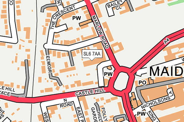
SL6 7AA lies on Marlow Road in Maidenhead. SL6 7AA is located in the St Mary's electoral ward, within the unitary authority of Windsor and Maidenhead and the English Parliamentary constituency of Maidenhead. The Sub Integrated Care Board (ICB) Location is NHS Frimley ICB - D4U1Y and the police force is Thames Valley. This postcode has been in use since January 1980.


GetTheData
Source: OS OpenMap – Local (Ordnance Survey)
Source: OS VectorMap District (Ordnance Survey)
Licence: Open Government Licence (requires attribution)
| Easting | 488511 |
| Northing | 181288 |
| Latitude | 51.523584 |
| Longitude | -0.725589 |
GetTheData
Source: Open Postcode Geo
Licence: Open Government Licence
| Street | Marlow Road |
| Town/City | Maidenhead |
| Country | England |
| Postcode District | SL6 |
➜ See where SL6 is on a map ➜ Where is Maidenhead? | |
GetTheData
Source: Land Registry Price Paid Data
Licence: Open Government Licence
Elevation or altitude of SL6 7AA as distance above sea level:
| Metres | Feet | |
|---|---|---|
| Elevation | 30m | 98ft |
Elevation is measured from the approximate centre of the postcode, to the nearest point on an OS contour line from OS Terrain 50, which has contour spacing of ten vertical metres.
➜ How high above sea level am I? Find the elevation of your current position using your device's GPS.
GetTheData
Source: Open Postcode Elevation
Licence: Open Government Licence
| Ward | St Mary's |
| Constituency | Maidenhead |
GetTheData
Source: ONS Postcode Database
Licence: Open Government Licence
| St Lukes Road (Marlow Road) | Maidenhead | 141m |
| St Lukes Road (Craufurd Rise) | Maidenhead | 204m |
| Frascati Way | Maidenhead Town Centre | 220m |
| Frascati Way | Maidenhead Town Centre | 241m |
| Frascati Way | Maidenhead Town Centre | 278m |
| Maidenhead Station | 0.6km |
| Furze Platt Station | 1.1km |
| Taplow Station | 3.1km |
GetTheData
Source: NaPTAN
Licence: Open Government Licence
| Percentage of properties with Next Generation Access | 100.0% |
| Percentage of properties with Superfast Broadband | 100.0% |
| Percentage of properties with Ultrafast Broadband | 0.0% |
| Percentage of properties with Full Fibre Broadband | 0.0% |
Superfast Broadband is between 30Mbps and 300Mbps
Ultrafast Broadband is > 300Mbps
| Median download speed | 78.1Mbps |
| Average download speed | 70.1Mbps |
| Maximum download speed | 80.00Mbps |
| Median upload speed | 19.5Mbps |
| Average upload speed | 17.0Mbps |
| Maximum upload speed | 20.00Mbps |
| Percentage of properties unable to receive 2Mbps | 0.0% |
| Percentage of properties unable to receive 5Mbps | 0.0% |
| Percentage of properties unable to receive 10Mbps | 0.0% |
| Percentage of properties unable to receive 30Mbps | 0.0% |
GetTheData
Source: Ofcom
Licence: Ofcom Terms of Use (requires attribution)
GetTheData
Source: ONS Postcode Database
Licence: Open Government Licence


➜ Get more ratings from the Food Standards Agency
GetTheData
Source: Food Standards Agency
Licence: FSA terms & conditions
| Last Collection | |||
|---|---|---|---|
| Location | Mon-Fri | Sat | Distance |
| The Crescent | 16:15 | 11:30 | 182m |
| High Town Road | 16:30 | 11:30 | 331m |
| Vicarage Road | 17:00 | 11:45 | 378m |
GetTheData
Source: Dracos
Licence: Creative Commons Attribution-ShareAlike
The below table lists the International Territorial Level (ITL) codes (formerly Nomenclature of Territorial Units for Statistics (NUTS) codes) and Local Administrative Units (LAU) codes for SL6 7AA:
| ITL 1 Code | Name |
|---|---|
| TLJ | South East (England) |
| ITL 2 Code | Name |
| TLJ1 | Berkshire, Buckinghamshire and Oxfordshire |
| ITL 3 Code | Name |
| TLJ11 | Berkshire |
| LAU 1 Code | Name |
| E06000040 | Windsor and Maidenhead |
GetTheData
Source: ONS Postcode Directory
Licence: Open Government Licence
The below table lists the Census Output Area (OA), Lower Layer Super Output Area (LSOA), and Middle Layer Super Output Area (MSOA) for SL6 7AA:
| Code | Name | |
|---|---|---|
| OA | E00083430 | |
| LSOA | E01016525 | Windsor and Maidenhead 005A |
| MSOA | E02003425 | Windsor and Maidenhead 005 |
GetTheData
Source: ONS Postcode Directory
Licence: Open Government Licence
| SL6 6FL | The Crescent | 19m |
| SL6 7AG | Marlow Road | 76m |
| SL6 6AA | The Crescent | 111m |
| SL6 6AB | The Crescent | 112m |
| SL6 4JJ | Castle Hill | 115m |
| SL6 6DY | Alston Gardens | 124m |
| SL6 6BY | Killarney Drive | 131m |
| SL6 7AQ | Marlow Road | 133m |
| SL6 4UZ | Frascati Way | 151m |
| SL6 1PQ | East Road | 157m |
GetTheData
Source: Open Postcode Geo; Land Registry Price Paid Data
Licence: Open Government Licence