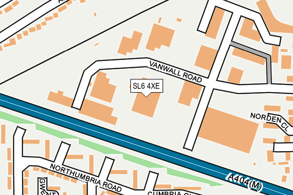
SL6 4XE is located in the Oldfield electoral ward, within the unitary authority of Windsor and Maidenhead and the English Parliamentary constituency of Maidenhead. The Sub Integrated Care Board (ICB) Location is NHS Frimley ICB - D4U1Y and the police force is Thames Valley. This postcode has been in use since January 1993.


GetTheData
Source: OS OpenMap – Local (Ordnance Survey)
Source: OS VectorMap District (Ordnance Survey)
Licence: Open Government Licence (requires attribution)
| Easting | 487090 |
| Northing | 179903 |
| Latitude | 51.511352 |
| Longitude | -0.746426 |
GetTheData
Source: Open Postcode Geo
Licence: Open Government Licence
| Country | England |
| Postcode District | SL6 |
➜ See where SL6 is on a map ➜ Where is Maidenhead? | |
GetTheData
Source: Land Registry Price Paid Data
Licence: Open Government Licence
Elevation or altitude of SL6 4XE as distance above sea level:
| Metres | Feet | |
|---|---|---|
| Elevation | 40m | 131ft |
Elevation is measured from the approximate centre of the postcode, to the nearest point on an OS contour line from OS Terrain 50, which has contour spacing of ten vertical metres.
➜ How high above sea level am I? Find the elevation of your current position using your device's GPS.
GetTheData
Source: Open Postcode Elevation
Licence: Open Government Licence
| Ward | Oldfield |
| Constituency | Maidenhead |
GetTheData
Source: ONS Postcode Database
Licence: Open Government Licence
| Vanwall Business Park (Vanwall Road) | Maidenhead | 81m |
| Lock Lane (Wessex Way) | Cox Green | 280m |
| Lock Lane (Wessex Way) | Cox Green | 280m |
| Wessex Way Shops (Wessex Way) | Cox Green | 423m |
| Haddon Road | Maidenhead | 425m |
| Maidenhead Station | 1.8km |
| Furze Platt Station | 2.7km |
| Taplow Station | 4.7km |
GetTheData
Source: NaPTAN
Licence: Open Government Licence
GetTheData
Source: ONS Postcode Database
Licence: Open Government Licence


➜ Get more ratings from the Food Standards Agency
GetTheData
Source: Food Standards Agency
Licence: FSA terms & conditions
| Last Collection | |||
|---|---|---|---|
| Location | Mon-Fri | Sat | Distance |
| Altwood Road | 17:30 | 11:45 | 470m |
| Wessex Way | 17:00 | 11:45 | 481m |
| Cox Green Post Office | 17:15 | 11:45 | 504m |
GetTheData
Source: Dracos
Licence: Creative Commons Attribution-ShareAlike
The below table lists the International Territorial Level (ITL) codes (formerly Nomenclature of Territorial Units for Statistics (NUTS) codes) and Local Administrative Units (LAU) codes for SL6 4XE:
| ITL 1 Code | Name |
|---|---|
| TLJ | South East (England) |
| ITL 2 Code | Name |
| TLJ1 | Berkshire, Buckinghamshire and Oxfordshire |
| ITL 3 Code | Name |
| TLJ11 | Berkshire |
| LAU 1 Code | Name |
| E06000040 | Windsor and Maidenhead |
GetTheData
Source: ONS Postcode Directory
Licence: Open Government Licence
The below table lists the Census Output Area (OA), Lower Layer Super Output Area (LSOA), and Middle Layer Super Output Area (MSOA) for SL6 4XE:
| Code | Name | |
|---|---|---|
| OA | E00083780 | |
| LSOA | E01016594 | Windsor and Maidenhead 007E |
| MSOA | E02003427 | Windsor and Maidenhead 007 |
GetTheData
Source: ONS Postcode Directory
Licence: Open Government Licence
| SL6 4UB | Vanwall Road | 92m |
| SL6 3DE | Northumbria Road | 171m |
| SL6 3DD | Cumbria Close | 191m |
| SL6 3DG | Northumbria Road | 217m |
| SL6 3DA | Northumbria Road | 230m |
| SL6 4PJ | Graham Close | 253m |
| SL6 3DQ | Northumbria Road | 258m |
| SL6 4BZ | Norden Close | 261m |
| SL6 3DF | Northumbria Road | 267m |
| SL6 3BS | Wessex Way | 267m |
GetTheData
Source: Open Postcode Geo; Land Registry Price Paid Data
Licence: Open Government Licence