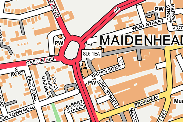
SL6 1EA is located in the St Mary's electoral ward, within the unitary authority of Windsor and Maidenhead and the English Parliamentary constituency of Maidenhead. The Sub Integrated Care Board (ICB) Location is NHS Frimley ICB - D4U1Y and the police force is Thames Valley. This postcode has been in use since January 1980.


GetTheData
Source: OS OpenMap – Local (Ordnance Survey)
Source: OS VectorMap District (Ordnance Survey)
Licence: Open Government Licence (requires attribution)
| Easting | 488641 |
| Northing | 181160 |
| Latitude | 51.522411 |
| Longitude | -0.723767 |
GetTheData
Source: Open Postcode Geo
Licence: Open Government Licence
| Country | England |
| Postcode District | SL6 |
➜ See where SL6 is on a map ➜ Where is Maidenhead? | |
GetTheData
Source: Land Registry Price Paid Data
Licence: Open Government Licence
Elevation or altitude of SL6 1EA as distance above sea level:
| Metres | Feet | |
|---|---|---|
| Elevation | 30m | 98ft |
Elevation is measured from the approximate centre of the postcode, to the nearest point on an OS contour line from OS Terrain 50, which has contour spacing of ten vertical metres.
➜ How high above sea level am I? Find the elevation of your current position using your device's GPS.
GetTheData
Source: Open Postcode Elevation
Licence: Open Government Licence
| Ward | St Mary's |
| Constituency | Maidenhead |
GetTheData
Source: ONS Postcode Database
Licence: Open Government Licence
| Frascati Way | Maidenhead Town Centre | 89m |
| Frascati Way | Maidenhead Town Centre | 104m |
| Frascati Way | Maidenhead Town Centre | 121m |
| Frascati Way | Maidenhead Town Centre | 142m |
| Broadway | Maidenhead Town Centre | 243m |
| Maidenhead Station | 0.4km |
| Furze Platt Station | 1.2km |
| Taplow Station | 2.9km |
GetTheData
Source: NaPTAN
Licence: Open Government Licence
GetTheData
Source: ONS Postcode Database
Licence: Open Government Licence


➜ Get more ratings from the Food Standards Agency
GetTheData
Source: Food Standards Agency
Licence: FSA terms & conditions
| Last Collection | |||
|---|---|---|---|
| Location | Mon-Fri | Sat | Distance |
| King Street | 17:30 | 11:45 | 251m |
| Old Town Hall Park Street | 17:30 | 11:45 | 276m |
| Queen Street | 17:00 | 12:00 | 303m |
GetTheData
Source: Dracos
Licence: Creative Commons Attribution-ShareAlike
The below table lists the International Territorial Level (ITL) codes (formerly Nomenclature of Territorial Units for Statistics (NUTS) codes) and Local Administrative Units (LAU) codes for SL6 1EA:
| ITL 1 Code | Name |
|---|---|
| TLJ | South East (England) |
| ITL 2 Code | Name |
| TLJ1 | Berkshire, Buckinghamshire and Oxfordshire |
| ITL 3 Code | Name |
| TLJ11 | Berkshire |
| LAU 1 Code | Name |
| E06000040 | Windsor and Maidenhead |
GetTheData
Source: ONS Postcode Directory
Licence: Open Government Licence
The below table lists the Census Output Area (OA), Lower Layer Super Output Area (LSOA), and Middle Layer Super Output Area (MSOA) for SL6 1EA:
| Code | Name | |
|---|---|---|
| OA | E00083768 | |
| LSOA | E01032734 | Windsor and Maidenhead 005H |
| MSOA | E02003425 | Windsor and Maidenhead 005 |
GetTheData
Source: ONS Postcode Directory
Licence: Open Government Licence
| SL6 1HR | Nicholsons Lane | 33m |
| SL6 1PT | High Street | 42m |
| SL6 1DR | King Street | 74m |
| SL6 4UZ | Frascati Way | 96m |
| SL6 1JX | High Street | 101m |
| SL6 1EF | King Street | 120m |
| SL6 1PR | Albert Street | 124m |
| SL6 1PG | Folly Hill Gardens | 137m |
| SL6 1NZ | Albert Street | 162m |
| SL6 1ED | King Street | 168m |
GetTheData
Source: Open Postcode Geo; Land Registry Price Paid Data
Licence: Open Government Licence