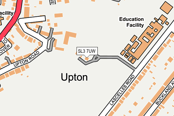
SL3 7UW is located in the Upton electoral ward, within the unitary authority of Slough and the English Parliamentary constituency of Slough. The Sub Integrated Care Board (ICB) Location is NHS Frimley ICB - D4U1Y and the police force is Thames Valley. This postcode has been in use since June 2015.


GetTheData
Source: OS OpenMap – Local (Ordnance Survey)
Source: OS VectorMap District (Ordnance Survey)
Licence: Open Government Licence (requires attribution)
| Easting | 498571 |
| Northing | 179291 |
| Latitude | 51.503967 |
| Longitude | -0.581207 |
GetTheData
Source: Open Postcode Geo
Licence: Open Government Licence
| Country | England |
| Postcode District | SL3 |
➜ See where SL3 is on a map ➜ Where is Slough? | |
GetTheData
Source: Land Registry Price Paid Data
Licence: Open Government Licence
Elevation or altitude of SL3 7UW as distance above sea level:
| Metres | Feet | |
|---|---|---|
| Elevation | 30m | 98ft |
Elevation is measured from the approximate centre of the postcode, to the nearest point on an OS contour line from OS Terrain 50, which has contour spacing of ten vertical metres.
➜ How high above sea level am I? Find the elevation of your current position using your device's GPS.
GetTheData
Source: Open Postcode Elevation
Licence: Open Government Licence
| Ward | Upton |
| Constituency | Slough |
GetTheData
Source: ONS Postcode Database
Licence: Open Government Licence
| Slough Grammar School (Sussex Place) | Langley | 346m |
| Uxbridge Road Sainsbury's (Wellington Street) | Langley | 350m |
| Long Close School (Upton Court Road) | Upton | 364m |
| High Street East (Yew Tree Road) | Slough Town Centre | 374m |
| High Street East (Uxbridge Road) | Slough Town Centre | 376m |
| Slough Station | 1.1km |
| Datchet Station | 2.3km |
| Windsor & Eton Riverside Station | 2.7km |
GetTheData
Source: NaPTAN
Licence: Open Government Licence
GetTheData
Source: ONS Postcode Database
Licence: Open Government Licence


➜ Get more ratings from the Food Standards Agency
GetTheData
Source: Food Standards Agency
Licence: FSA terms & conditions
| Last Collection | |||
|---|---|---|---|
| Location | Mon-Fri | Sat | Distance |
| Dolphin Road | 19:00 | 10:30 | 363m |
| High Street (Regency) | 17:45 | 13:00 | 390m |
| Albert Street | 17:45 | 13:00 | 623m |
GetTheData
Source: Dracos
Licence: Creative Commons Attribution-ShareAlike
The below table lists the International Territorial Level (ITL) codes (formerly Nomenclature of Territorial Units for Statistics (NUTS) codes) and Local Administrative Units (LAU) codes for SL3 7UW:
| ITL 1 Code | Name |
|---|---|
| TLJ | South East (England) |
| ITL 2 Code | Name |
| TLJ1 | Berkshire, Buckinghamshire and Oxfordshire |
| ITL 3 Code | Name |
| TLJ11 | Berkshire |
| LAU 1 Code | Name |
| E06000039 | Slough |
GetTheData
Source: ONS Postcode Directory
Licence: Open Government Licence
The below table lists the Census Output Area (OA), Lower Layer Super Output Area (LSOA), and Middle Layer Super Output Area (MSOA) for SL3 7UW:
| Code | Name | |
|---|---|---|
| OA | E00083371 | |
| LSOA | E01016511 | Slough 011A |
| MSOA | E02003417 | Slough 011 |
GetTheData
Source: ONS Postcode Directory
Licence: Open Government Licence
| SL1 2AD | Upton Road | 177m |
| SL3 7PW | Lascelles Road | 206m |
| SL1 2AB | Harewood Place | 207m |
| SL1 1NX | Sussex Close | 209m |
| SL1 2AL | Upton Road | 215m |
| SL1 1NU | Nixey Close | 218m |
| SL3 7PN | Lascelles Road | 247m |
| SL1 1NY | Sussex Keep | 249m |
| SL1 1LU | Nixey Close | 252m |
| SL1 1NR | Sussex Place | 268m |
GetTheData
Source: Open Postcode Geo; Land Registry Price Paid Data
Licence: Open Government Licence