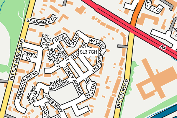
SL3 7GH is located in the Colnbrook & Poyle electoral ward, within the unitary authority of Slough and the English Parliamentary constituency of Slough. The Sub Integrated Care Board (ICB) Location is NHS Frimley ICB - D4U1Y and the police force is Thames Valley. This postcode has been in use since March 2005.


GetTheData
Source: OS OpenMap – Local (Ordnance Survey)
Source: OS VectorMap District (Ordnance Survey)
Licence: Open Government Licence (requires attribution)
| Easting | 500766 |
| Northing | 178106 |
| Latitude | 51.492929 |
| Longitude | -0.549931 |
GetTheData
Source: Open Postcode Geo
Licence: Open Government Licence
| Country | England |
| Postcode District | SL3 |
➜ See where SL3 is on a map ➜ Where is Slough? | |
GetTheData
Source: Land Registry Price Paid Data
Licence: Open Government Licence
Elevation or altitude of SL3 7GH as distance above sea level:
| Metres | Feet | |
|---|---|---|
| Elevation | 20m | 66ft |
Elevation is measured from the approximate centre of the postcode, to the nearest point on an OS contour line from OS Terrain 50, which has contour spacing of ten vertical metres.
➜ How high above sea level am I? Find the elevation of your current position using your device's GPS.
GetTheData
Source: Open Postcode Elevation
Licence: Open Government Licence
| Ward | Colnbrook & Poyle |
| Constituency | Slough |
GetTheData
Source: ONS Postcode Database
Licence: Open Government Licence
| The Toby (London Road) | Langley | 152m |
| The Toby (Ditton Road) | Langley | 169m |
| Marriott Hotel (Hotel Grounds) | Langley | 190m |
| Ditton Park Road (London Road) | Langley | 215m |
| The Toby (London Road) | Langley | 238m |
| Langley (Berks) Station | 1.8km |
| Datchet Station | 2.3km |
| Sunnymeads Station | 2.6km |
GetTheData
Source: NaPTAN
Licence: Open Government Licence
| Percentage of properties with Next Generation Access | 100.0% |
| Percentage of properties with Superfast Broadband | 100.0% |
| Percentage of properties with Ultrafast Broadband | 0.0% |
| Percentage of properties with Full Fibre Broadband | 0.0% |
Superfast Broadband is between 30Mbps and 300Mbps
Ultrafast Broadband is > 300Mbps
| Percentage of properties unable to receive 2Mbps | 0.0% |
| Percentage of properties unable to receive 5Mbps | 0.0% |
| Percentage of properties unable to receive 10Mbps | 0.0% |
| Percentage of properties unable to receive 30Mbps | 0.0% |
GetTheData
Source: Ofcom
Licence: Ofcom Terms of Use (requires attribution)
Estimated total energy consumption in SL3 7GH by fuel type, 2015.
| Consumption (kWh) | 40,207 |
|---|---|
| Meter count | 6 |
| Mean (kWh/meter) | 6,701 |
| Median (kWh/meter) | 6,286 |
| Consumption (kWh) | 11,270 |
|---|---|
| Meter count | 6 |
| Mean (kWh/meter) | 1,878 |
| Median (kWh/meter) | 1,836 |
GetTheData
Source: Postcode level gas estimates: 2015 (experimental)
Source: Postcode level electricity estimates: 2015 (experimental)
Licence: Open Government Licence
GetTheData
Source: ONS Postcode Database
Licence: Open Government Licence


➜ Get more ratings from the Food Standards Agency
GetTheData
Source: Food Standards Agency
Licence: FSA terms & conditions
| Last Collection | |||
|---|---|---|---|
| Location | Mon-Fri | Sat | Distance |
| Hermitage Close | 17:45 | 11:45 | 832m |
| High Street | 18:30 | 13:00 | 915m |
| Parlaunt Road Post Office | 18:00 | 13:00 | 1,049m |
GetTheData
Source: Dracos
Licence: Creative Commons Attribution-ShareAlike
The below table lists the International Territorial Level (ITL) codes (formerly Nomenclature of Territorial Units for Statistics (NUTS) codes) and Local Administrative Units (LAU) codes for SL3 7GH:
| ITL 1 Code | Name |
|---|---|
| TLJ | South East (England) |
| ITL 2 Code | Name |
| TLJ1 | Berkshire, Buckinghamshire and Oxfordshire |
| ITL 3 Code | Name |
| TLJ11 | Berkshire |
| LAU 1 Code | Name |
| E06000039 | Slough |
GetTheData
Source: ONS Postcode Directory
Licence: Open Government Licence
The below table lists the Census Output Area (OA), Lower Layer Super Output Area (LSOA), and Middle Layer Super Output Area (MSOA) for SL3 7GH:
| Code | Name | |
|---|---|---|
| OA | E00166703 | |
| LSOA | E01032731 | Slough 013E |
| MSOA | E02003419 | Slough 013 |
GetTheData
Source: ONS Postcode Directory
Licence: Open Government Licence
| SL3 7GB | Walker Crescent | 25m |
| SL3 7GJ | Sharman Row | 42m |
| SL3 7GN | Tracy Avenue | 79m |
| SL3 7GL | Olivia Drive | 86m |
| SL3 7GS | Davison Road | 92m |
| SL3 7GR | Gilbert Way | 107m |
| SL3 7GP | Beckett Chase | 108m |
| SL3 7GA | Dalton Green | 117m |
| SL3 8PP | Ditton Road | 131m |
| SL3 8PR | Ditton Road | 141m |
GetTheData
Source: Open Postcode Geo; Land Registry Price Paid Data
Licence: Open Government Licence