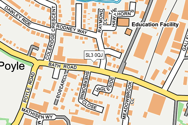
SL3 0QJ lies on Bath Road in Colnbrook, Slough. SL3 0QJ is located in the Colnbrook & Poyle electoral ward, within the unitary authority of Slough and the English Parliamentary constituency of Windsor. The Sub Integrated Care Board (ICB) Location is NHS Frimley ICB - D4U1Y and the police force is Thames Valley. This postcode has been in use since December 2005.


GetTheData
Source: OS OpenMap – Local (Ordnance Survey)
Source: OS VectorMap District (Ordnance Survey)
Licence: Open Government Licence (requires attribution)
| Easting | 503468 |
| Northing | 176698 |
| Latitude | 51.479786 |
| Longitude | -0.511437 |
GetTheData
Source: Open Postcode Geo
Licence: Open Government Licence
| Street | Bath Road |
| Locality | Colnbrook |
| Town/City | Slough |
| Country | England |
| Postcode District | SL3 |
➜ See where SL3 is on a map ➜ Where is Poyle? | |
GetTheData
Source: Land Registry Price Paid Data
Licence: Open Government Licence
Elevation or altitude of SL3 0QJ as distance above sea level:
| Metres | Feet | |
|---|---|---|
| Elevation | 20m | 66ft |
Elevation is measured from the approximate centre of the postcode, to the nearest point on an OS contour line from OS Terrain 50, which has contour spacing of ten vertical metres.
➜ How high above sea level am I? Find the elevation of your current position using your device's GPS.
GetTheData
Source: Open Postcode Elevation
Licence: Open Government Licence
| Ward | Colnbrook & Poyle |
| Constituency | Windsor |
GetTheData
Source: ONS Postcode Database
Licence: Open Government Licence
| Poyle Road Junction (Bath Road) | Colnbrook | 78m |
| Holiday Inn T5 Forecourt (Bath Road) | Colnbrook | 111m |
| Poyle Road Junction (Bath Road) | Colnbrook | 112m |
| Galleymead Road (Bath Road) | Colnbrook | 122m |
| Poyle Road Junction (Coleridge Crescent) | Colnbrook | 142m |
| Heathrow Terminal 5 Underground Station | Heathrow Airport Terminal 5 | 1,810m |
| Heathrow Airport Terminal 5 | 1.8km |
| Heathrow Terminal 5 Station | 1.8km |
| Iver Station | 3.2km |
GetTheData
Source: NaPTAN
Licence: Open Government Licence
| Percentage of properties with Next Generation Access | 100.0% |
| Percentage of properties with Superfast Broadband | 100.0% |
| Percentage of properties with Ultrafast Broadband | 0.0% |
| Percentage of properties with Full Fibre Broadband | 0.0% |
Superfast Broadband is between 30Mbps and 300Mbps
Ultrafast Broadband is > 300Mbps
| Percentage of properties unable to receive 2Mbps | 0.0% |
| Percentage of properties unable to receive 5Mbps | 0.0% |
| Percentage of properties unable to receive 10Mbps | 0.0% |
| Percentage of properties unable to receive 30Mbps | 0.0% |
GetTheData
Source: Ofcom
Licence: Ofcom Terms of Use (requires attribution)
GetTheData
Source: ONS Postcode Database
Licence: Open Government Licence


➜ Get more ratings from the Food Standards Agency
GetTheData
Source: Food Standards Agency
Licence: FSA terms & conditions
| Last Collection | |||
|---|---|---|---|
| Location | Mon-Fri | Sat | Distance |
| Blackthorne Road | 18:30 | 833m | |
| Blackthorne Road | 18:30 | 12:30 | 836m |
| Grassholm Way | 18:00 | 10:45 | 1,394m |
GetTheData
Source: Dracos
Licence: Creative Commons Attribution-ShareAlike
The below table lists the International Territorial Level (ITL) codes (formerly Nomenclature of Territorial Units for Statistics (NUTS) codes) and Local Administrative Units (LAU) codes for SL3 0QJ:
| ITL 1 Code | Name |
|---|---|
| TLJ | South East (England) |
| ITL 2 Code | Name |
| TLJ1 | Berkshire, Buckinghamshire and Oxfordshire |
| ITL 3 Code | Name |
| TLJ11 | Berkshire |
| LAU 1 Code | Name |
| E06000039 | Slough |
GetTheData
Source: ONS Postcode Directory
Licence: Open Government Licence
The below table lists the Census Output Area (OA), Lower Layer Super Output Area (LSOA), and Middle Layer Super Output Area (MSOA) for SL3 0QJ:
| Code | Name | |
|---|---|---|
| OA | E00083229 | |
| LSOA | E01016482 | Slough 014D |
| MSOA | E02003420 | Slough 014 |
GetTheData
Source: ONS Postcode Directory
Licence: Open Government Licence
| SL3 0NZ | Old Bath Road | 50m |
| SL3 0NH | The Lawns | 52m |
| SL3 0PN | Rodney Way | 69m |
| SL3 0PD | Ingleside | 76m |
| SL3 0PG | Harbans Court | 80m |
| SL3 0PW | Daventry Close | 85m |
| SL3 0PH | Old Bath Road | 89m |
| SL3 0PB | Sherborne Close | 117m |
| SL3 0NN | Old Bath Road | 119m |
| SL3 0PL | Coleridge Crescent | 132m |
GetTheData
Source: Open Postcode Geo; Land Registry Price Paid Data
Licence: Open Government Licence