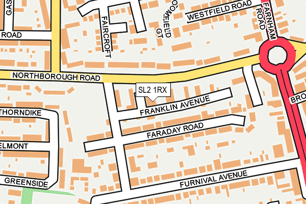
SL2 1RX lies on Franklin Avenue in Slough. SL2 1RX is located in the Farnham electoral ward, within the unitary authority of Slough and the English Parliamentary constituency of Slough. The Sub Integrated Care Board (ICB) Location is NHS Frimley ICB - D4U1Y and the police force is Thames Valley. This postcode has been in use since January 1980.


GetTheData
Source: OS OpenMap – Local (Ordnance Survey)
Source: OS VectorMap District (Ordnance Survey)
Licence: Open Government Licence (requires attribution)
| Easting | 495779 |
| Northing | 181997 |
| Latitude | 51.528771 |
| Longitude | -0.620687 |
GetTheData
Source: Open Postcode Geo
Licence: Open Government Licence
| Street | Franklin Avenue |
| Town/City | Slough |
| Country | England |
| Postcode District | SL2 |
➜ See where SL2 is on a map ➜ Where is Slough? | |
GetTheData
Source: Land Registry Price Paid Data
Licence: Open Government Licence
Elevation or altitude of SL2 1RX as distance above sea level:
| Metres | Feet | |
|---|---|---|
| Elevation | 40m | 131ft |
Elevation is measured from the approximate centre of the postcode, to the nearest point on an OS contour line from OS Terrain 50, which has contour spacing of ten vertical metres.
➜ How high above sea level am I? Find the elevation of your current position using your device's GPS.
GetTheData
Source: Open Postcode Elevation
Licence: Open Government Licence
| Ward | Farnham |
| Constituency | Slough |
GetTheData
Source: ONS Postcode Database
Licence: Open Government Licence
| Trevose House (Northborough Road) | Britwell | 128m |
| Franklin Ave Playground (Northborough Road) | Britwell | 145m |
| Trevose House (Northborough Road) | Britwell | 163m |
| Cowper Road (Long Readings Lane) | Britwell | 251m |
| Cowper Road (Long Readings Lane) | Britwell | 319m |
| Burnham (Berks) Station | 1.9km |
| Slough Station | 2.8km |
| Taplow Station | 4.3km |
GetTheData
Source: NaPTAN
Licence: Open Government Licence
| Percentage of properties with Next Generation Access | 100.0% |
| Percentage of properties with Superfast Broadband | 100.0% |
| Percentage of properties with Ultrafast Broadband | 97.6% |
| Percentage of properties with Full Fibre Broadband | 0.0% |
Superfast Broadband is between 30Mbps and 300Mbps
Ultrafast Broadband is > 300Mbps
| Median download speed | 78.8Mbps |
| Average download speed | 77.5Mbps |
| Maximum download speed | 200.00Mbps |
| Median upload speed | 12.1Mbps |
| Average upload speed | 12.8Mbps |
| Maximum upload speed | 20.00Mbps |
| Percentage of properties unable to receive 2Mbps | 0.0% |
| Percentage of properties unable to receive 5Mbps | 0.0% |
| Percentage of properties unable to receive 10Mbps | 0.0% |
| Percentage of properties unable to receive 30Mbps | 0.0% |
GetTheData
Source: Ofcom
Licence: Ofcom Terms of Use (requires attribution)
Estimated total energy consumption in SL2 1RX by fuel type, 2015.
| Consumption (kWh) | 386,556 |
|---|---|
| Meter count | 40 |
| Mean (kWh/meter) | 9,664 |
| Median (kWh/meter) | 8,903 |
| Consumption (kWh) | 100,382 |
|---|---|
| Meter count | 40 |
| Mean (kWh/meter) | 2,510 |
| Median (kWh/meter) | 2,263 |
GetTheData
Source: Postcode level gas estimates: 2015 (experimental)
Source: Postcode level electricity estimates: 2015 (experimental)
Licence: Open Government Licence
GetTheData
Source: ONS Postcode Database
Licence: Open Government Licence


➜ Get more ratings from the Food Standards Agency
GetTheData
Source: Food Standards Agency
Licence: FSA terms & conditions
| Last Collection | |||
|---|---|---|---|
| Location | Mon-Fri | Sat | Distance |
| Ambassador | 18:00 | 12:45 | 308m |
| The Willoners | 18:15 | 10:30 | 331m |
| Farnham Road | 413m | ||
GetTheData
Source: Dracos
Licence: Creative Commons Attribution-ShareAlike
The below table lists the International Territorial Level (ITL) codes (formerly Nomenclature of Territorial Units for Statistics (NUTS) codes) and Local Administrative Units (LAU) codes for SL2 1RX:
| ITL 1 Code | Name |
|---|---|
| TLJ | South East (England) |
| ITL 2 Code | Name |
| TLJ1 | Berkshire, Buckinghamshire and Oxfordshire |
| ITL 3 Code | Name |
| TLJ11 | Berkshire |
| LAU 1 Code | Name |
| E06000039 | Slough |
GetTheData
Source: ONS Postcode Directory
Licence: Open Government Licence
The below table lists the Census Output Area (OA), Lower Layer Super Output Area (LSOA), and Middle Layer Super Output Area (MSOA) for SL2 1RX:
| Code | Name | |
|---|---|---|
| OA | E00083243 | |
| LSOA | E01016486 | Slough 002D |
| MSOA | E02003408 | Slough 002 |
GetTheData
Source: ONS Postcode Directory
Licence: Open Government Licence
| SL2 1RU | Faraday Road | 62m |
| SL2 1RN | Faraday Road | 84m |
| SL2 1PS | Northborough Road | 95m |
| SL2 1HQ | Sandlers End | 121m |
| SL2 1RS | Faraday Road | 125m |
| SL2 1RP | Faraday Road | 143m |
| SL2 1PX | Northborough Road | 149m |
| SL2 1HH | Broomfield Gate | 150m |
| SL2 1DW | Furnival Avenue | 152m |
| SL2 1RW | Faraday Road | 155m |
GetTheData
Source: Open Postcode Geo; Land Registry Price Paid Data
Licence: Open Government Licence