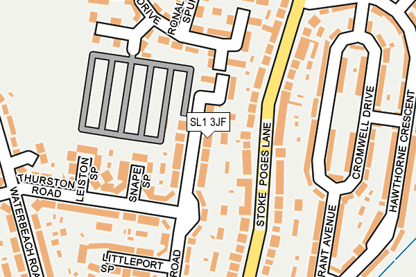
SL1 3JF lies on Mildenhall Road in Slough. SL1 3JF is located in the Manor Park & Stoke electoral ward, within the unitary authority of Slough and the English Parliamentary constituency of Slough. The Sub Integrated Care Board (ICB) Location is NHS Frimley ICB - D4U1Y and the police force is Thames Valley. This postcode has been in use since January 1980.


GetTheData
Source: OS OpenMap – Local (Ordnance Survey)
Source: OS VectorMap District (Ordnance Survey)
Licence: Open Government Licence (requires attribution)
| Easting | 497243 |
| Northing | 181425 |
| Latitude | 51.523379 |
| Longitude | -0.599747 |
GetTheData
Source: Open Postcode Geo
Licence: Open Government Licence
| Street | Mildenhall Road |
| Town/City | Slough |
| Country | England |
| Postcode District | SL1 |
➜ See where SL1 is on a map ➜ Where is Slough? | |
GetTheData
Source: Land Registry Price Paid Data
Licence: Open Government Licence
Elevation or altitude of SL1 3JF as distance above sea level:
| Metres | Feet | |
|---|---|---|
| Elevation | 30m | 98ft |
Elevation is measured from the approximate centre of the postcode, to the nearest point on an OS contour line from OS Terrain 50, which has contour spacing of ten vertical metres.
➜ How high above sea level am I? Find the elevation of your current position using your device's GPS.
GetTheData
Source: Open Postcode Elevation
Licence: Open Government Licence
| Ward | Manor Park & Stoke |
| Constituency | Slough |
GetTheData
Source: ONS Postcode Database
Licence: Open Government Licence
| Stoke Poges Lane | Baylis | 97m |
| Stoke Poges Lane | Baylis | 115m |
| Cherry Picker Ph (Stoke Poges Lane) | Manor Park | 218m |
| Cherry Picker Ph (Stoke Poges Lane) | Manor Park | 303m |
| Oatlands Drive | Baylis | 391m |
| Slough Station | 1.4km |
| Burnham (Berks) Station | 3.2km |
| Windsor & Eton Riverside Station | 4.2km |
GetTheData
Source: NaPTAN
Licence: Open Government Licence
| Percentage of properties with Next Generation Access | 100.0% |
| Percentage of properties with Superfast Broadband | 100.0% |
| Percentage of properties with Ultrafast Broadband | 100.0% |
| Percentage of properties with Full Fibre Broadband | 0.0% |
Superfast Broadband is between 30Mbps and 300Mbps
Ultrafast Broadband is > 300Mbps
| Median download speed | 70.0Mbps |
| Average download speed | 75.9Mbps |
| Maximum download speed | 350.00Mbps |
| Median upload speed | 10.0Mbps |
| Average upload speed | 12.3Mbps |
| Maximum upload speed | 24.18Mbps |
| Percentage of properties unable to receive 2Mbps | 0.0% |
| Percentage of properties unable to receive 5Mbps | 0.0% |
| Percentage of properties unable to receive 10Mbps | 0.0% |
| Percentage of properties unable to receive 30Mbps | 0.0% |
GetTheData
Source: Ofcom
Licence: Ofcom Terms of Use (requires attribution)
Estimated total energy consumption in SL1 3JF by fuel type, 2015.
| Consumption (kWh) | 578,952 |
|---|---|
| Meter count | 42 |
| Mean (kWh/meter) | 13,785 |
| Median (kWh/meter) | 11,547 |
| Consumption (kWh) | 136,807 |
|---|---|
| Meter count | 42 |
| Mean (kWh/meter) | 3,257 |
| Median (kWh/meter) | 3,221 |
GetTheData
Source: Postcode level gas estimates: 2015 (experimental)
Source: Postcode level electricity estimates: 2015 (experimental)
Licence: Open Government Licence
GetTheData
Source: ONS Postcode Database
Licence: Open Government Licence


➜ Get more ratings from the Food Standards Agency
GetTheData
Source: Food Standards Agency
Licence: FSA terms & conditions
| Last Collection | |||
|---|---|---|---|
| Location | Mon-Fri | Sat | Distance |
| Stoke Poges Lane | 18:00 | 13:00 | 202m |
| Cromwell Drive | 18:00 | 11:00 | 234m |
| Granville Avenue | 18:00 | 11:00 | 276m |
GetTheData
Source: Dracos
Licence: Creative Commons Attribution-ShareAlike
The below table lists the International Territorial Level (ITL) codes (formerly Nomenclature of Territorial Units for Statistics (NUTS) codes) and Local Administrative Units (LAU) codes for SL1 3JF:
| ITL 1 Code | Name |
|---|---|
| TLJ | South East (England) |
| ITL 2 Code | Name |
| TLJ1 | Berkshire, Buckinghamshire and Oxfordshire |
| ITL 3 Code | Name |
| TLJ11 | Berkshire |
| LAU 1 Code | Name |
| E06000039 | Slough |
GetTheData
Source: ONS Postcode Directory
Licence: Open Government Licence
The below table lists the Census Output Area (OA), Lower Layer Super Output Area (LSOA), and Middle Layer Super Output Area (MSOA) for SL1 3JF:
| Code | Name | |
|---|---|---|
| OA | E00083053 | |
| LSOA | E01016445 | Slough 004B |
| MSOA | E02003410 | Slough 004 |
GetTheData
Source: ONS Postcode Directory
Licence: Open Government Licence
| SL1 3JH | Mildenhall Road | 48m |
| SL1 3JL | Snape Spur | 106m |
| SL1 3LX | Stoke Poges Lane | 108m |
| SL1 3XU | Lerwick Drive | 131m |
| SL1 3LH | Stoke Poges Lane | 131m |
| SL1 3LJ | Stoke Poges Lane | 144m |
| SL1 3LU | Stoke Poges Lane | 153m |
| SL1 3ND | Cromwell Drive | 156m |
| SL1 3JN | Leiston Spur | 165m |
| SL1 3JJ | Thurston Road | 177m |
GetTheData
Source: Open Postcode Geo; Land Registry Price Paid Data
Licence: Open Government Licence