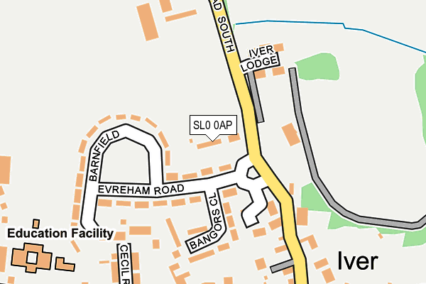
SL0 0AP lies on Bangors Road South in Iver. SL0 0AP is located in the Iver electoral ward, within the unitary authority of Buckinghamshire and the English Parliamentary constituency of Beaconsfield. The Sub Integrated Care Board (ICB) Location is NHS Buckinghamshire, Oxfordshire and Berkshire West ICB - 14Y and the police force is Thames Valley. This postcode has been in use since January 1980.


GetTheData
Source: OS OpenMap – Local (Ordnance Survey)
Source: OS VectorMap District (Ordnance Survey)
Licence: Open Government Licence (requires attribution)
| Easting | 503529 |
| Northing | 181484 |
| Latitude | 51.522795 |
| Longitude | -0.509136 |
GetTheData
Source: Open Postcode Geo
Licence: Open Government Licence
| Street | Bangors Road South |
| Town/City | Iver |
| Country | England |
| Postcode District | SL0 |
➜ See where SL0 is on a map ➜ Where is Iver? | |
GetTheData
Source: Land Registry Price Paid Data
Licence: Open Government Licence
Elevation or altitude of SL0 0AP as distance above sea level:
| Metres | Feet | |
|---|---|---|
| Elevation | 40m | 131ft |
Elevation is measured from the approximate centre of the postcode, to the nearest point on an OS contour line from OS Terrain 50, which has contour spacing of ten vertical metres.
➜ How high above sea level am I? Find the elevation of your current position using your device's GPS.
GetTheData
Source: Open Postcode Elevation
Licence: Open Government Licence
| Ward | Iver |
| Constituency | Beaconsfield |
GetTheData
Source: ONS Postcode Database
Licence: Open Government Licence
| Evreham Road (Bangors Road South) | Iver | 24m |
| Evreham Road (Bangors Road South) | Iver | 50m |
| King's Church (High Street) | Iver | 237m |
| King's Church (High Street) | Iver | 246m |
| Chequers Orchard (High Street) | Iver | 280m |
| Iver Station | 1.6km |
| Langley (Berks) Station | 2.8km |
| West Drayton Station | 2.9km |
GetTheData
Source: NaPTAN
Licence: Open Government Licence
GetTheData
Source: ONS Postcode Database
Licence: Open Government Licence


➜ Get more ratings from the Food Standards Agency
GetTheData
Source: Food Standards Agency
Licence: FSA terms & conditions
| Last Collection | |||
|---|---|---|---|
| Location | Mon-Fri | Sat | Distance |
| High Street | 17:15 | 11:00 | 476m |
| Shredding Green | 15:45 | 11:00 | 1,316m |
| Bathurst Walk | 18:30 | 12:30 | 1,688m |
GetTheData
Source: Dracos
Licence: Creative Commons Attribution-ShareAlike
The below table lists the International Territorial Level (ITL) codes (formerly Nomenclature of Territorial Units for Statistics (NUTS) codes) and Local Administrative Units (LAU) codes for SL0 0AP:
| ITL 1 Code | Name |
|---|---|
| TLJ | South East (England) |
| ITL 2 Code | Name |
| TLJ1 | Berkshire, Buckinghamshire and Oxfordshire |
| ITL 3 Code | Name |
| TLJ13 | Buckinghamshire |
| LAU 1 Code | Name |
| E06000060 | Buckinghamshire |
GetTheData
Source: ONS Postcode Directory
Licence: Open Government Licence
The below table lists the Census Output Area (OA), Lower Layer Super Output Area (LSOA), and Middle Layer Super Output Area (MSOA) for SL0 0AP:
| Code | Name | |
|---|---|---|
| OA | E00089963 | |
| LSOA | E01017827 | South Bucks 008D |
| MSOA | E02003695 | South Bucks 008 |
GetTheData
Source: ONS Postcode Directory
Licence: Open Government Licence
| SL0 0AN | Evreham Road | 57m |
| SL0 0AW | Bangors Road South | 114m |
| SL0 0AG | Bangors Road South | 132m |
| SL0 0AJ | Bangors Close | 136m |
| SL0 0AH | Evreham Road | 139m |
| SL0 0AA | Bangors Road South | 153m |
| SL0 0AE | Croft Cottages | 185m |
| SL0 9PL | Kingsway | 197m |
| SL0 0AD | Bangors Road South | 203m |
| SL0 0AL | Barnfield | 214m |
GetTheData
Source: Open Postcode Geo; Land Registry Price Paid Data
Licence: Open Government Licence